John Dales and his team at Urban Movement assessed the modern utility of twelve of these period cycle tracks. Urban Movement’s draft findings [PDF] were submitted to the Department for Transport.
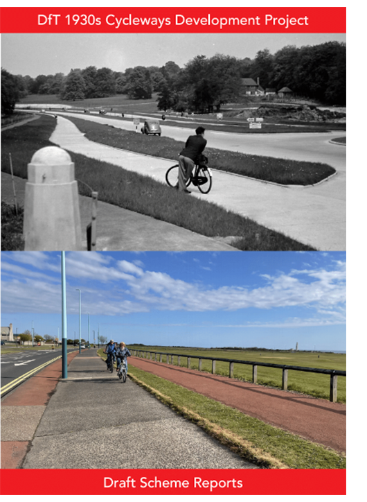
The purpose of this Development Project, which has been undertaken in parallel with the research project by Carlton Reid, is essentially twofold: to explore the potential for some of these historic cycleways to serve as valuable parts of the contemporary cycling network; and to work with willing highway authorities to bring forward proposals, backed where appropriate with initial designs, for the improvement and integration of selected cycleways as part of a modern network that meets the standards of provision for cycling set out in Local Transport Note 1/20 (Cycle Infrastructure Design). The key outcome from the work is that local authority officers will be better able to prepare convincing funding bids for design development and the delivery of better conditions for cycling in due course.
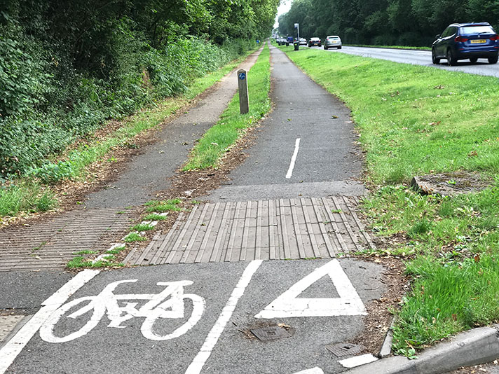
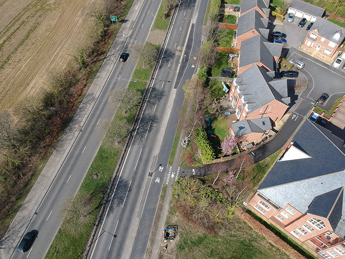
The 1930s cycleways gave a high standard of provision. They were separate, protected and, at almost 3m wide, suitable for bi-directional cycling. Perhaps the key flaw with all the 1930s schemes, however, is that they did not carry priority for cycling through even the smallest junctions. The layout of quiet side street T-junctions are typically bell-mouthed, with large radii that both increase the crossing distance (on foot or cycle) and enable motor vehicles to turn at relatively high speeds. At major junctions, like large roundabouts, the cycleways simply stop altogether, feeding cyclists abruptly into the nearside lane. Another common flaw was that, since they were only constructed as part of a road scheme, the cycleways did not form part of a connected network. Consequently, many of the schemes are relatively short (sometimes less than 1km) and a large number do not connect places between which people might want to travel. Some are alongside bypasses ‘in the middle of nowhere’, while others are in residential areas, but do not link them with any significant employment, commercial or educational centres.
Many of the schemes were built alongside dual carriageways. In such circumstances it is important that cycling is allowed in both directions on both sides of the road. This is because, with crossing the road being difficult and formal opportunities to do so being infrequent, people cannot be expected only to ride ‘with flow’ on one side of the road, against their desired direction of travel, in order to cross to the other side at some point and head back the way they wanted to go in the first place.
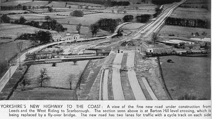
Whether or not this was the specific intention, the 9ft width of the tracks enabled bi-directional cycling with reasonable comfort. A variety of historic imagery is presented to illustrate both the way in which the cycleway designs were directly influenced by Dutch precedents and how the schemes looked at or near the time of opening.
PROCESS
The Development Project was undertaken by way of the following three main sequential work stages:
Stage 1. Long-listing of potentially suitable cycleways, based on research by Carlton Reid. This will consider factors including current condition, location, and the relationship (actual or potential) with the other parts of the local cycling network.
Stage 2. Short-listing of the cycleways most suitable for development, through initial discussions with the relevant local authorities. This enabled greater clarity to be achieved concerning the value of the 1930s cycleways in local network-building, and was also a check on the willingness and ability of each authority to commit to pursuing the creation of cycling infrastructure consistent with LTN 1/20.
Stage 3. Preparation of an itemised schedule of improvement measures for each of the selected 1930s cycleways schemes, including – as appropriate – proposals for extending the historic infrastructure to connect better with adjacent parts of the cycling network. Where necessary and helpful, this work was supported by the preparation of concept designs for selected locations.
THE SCHEMES
Links Road — Blyth, Northumberland
The Links — Whitley Bay, North Tyneside
Euxton Lane — Euxton/Chorley, Lancashire
Formby Bypass — Sefton, Merseyside
Harpfield Road — Stoke-on-Trent
Arnold Road — Nottingham
Raynesway — Derby
Melton Road — Leicester
Kenilworth Road — Coventry
Marston Road — Oxford
Uxbridge Road — Hayes, Hillingdon
Mickleham Bypass — Surrey
++++
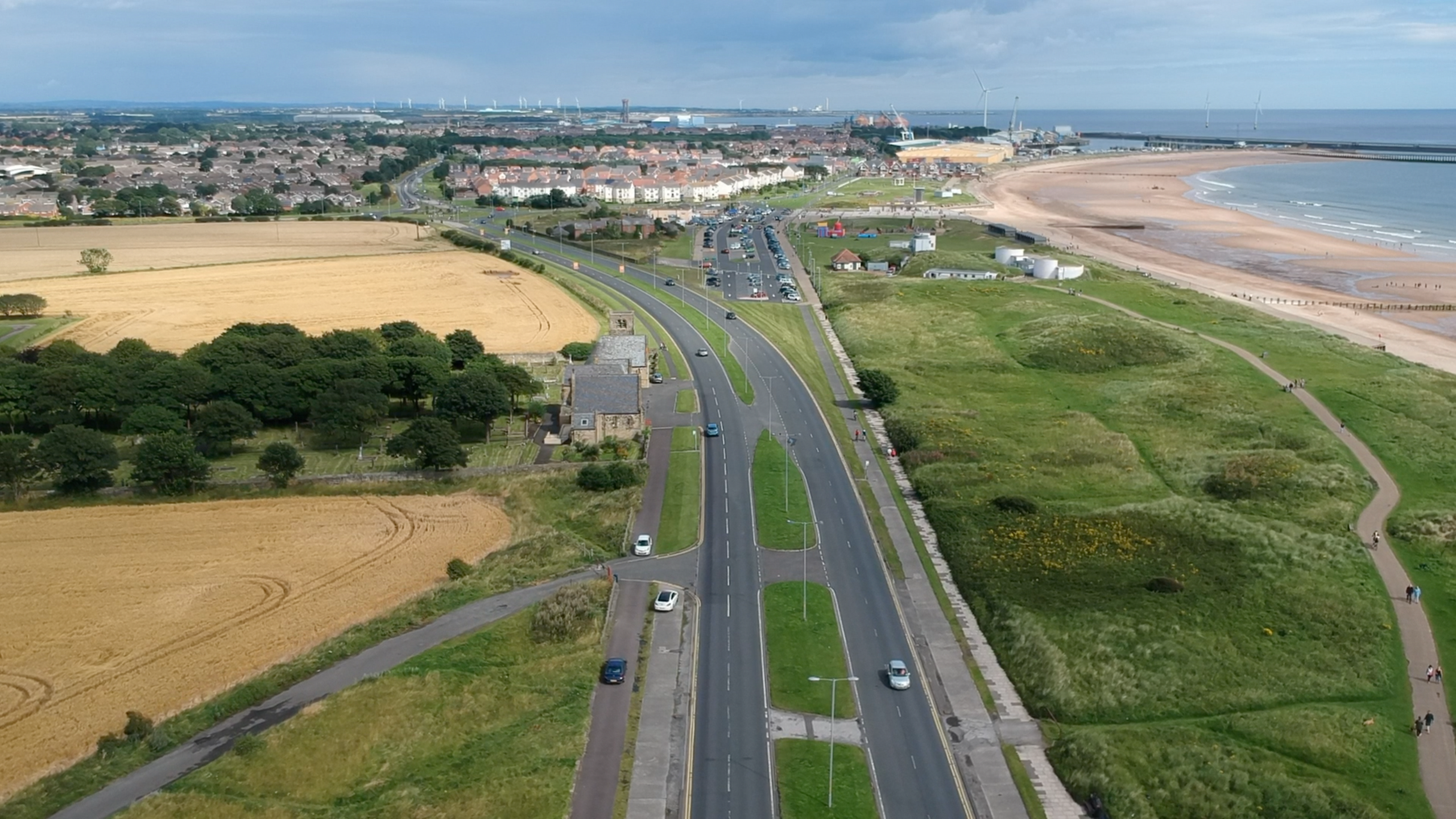
Links Road, Blyth, Northumberland + The Links, Whitley Bay, North Tyneside
BLYTH
Location: A193 Links Road, Blyth
Original Length: 900m
Authority: Northumberland County Council
WHITLEY BAY
Location: A193, The Links (previously Blyth Road)
Original Length: 800m
Authority: North Tyneside Council
The Blyth and Whitley Bay 1930s cycleways are the second and third most northerly of the schemes so far identified in England. They are somewhat unusual in that, despite being distinct schemes – more than 5km separates them – they are nevertheless both close to one another and are alongside the same road. The road in question is the A193, which runs from Newcastle to Bedlington in Northumberland and, in doing so, follows the North Sea coast from Tynemouth to Blyth via Whitley Bay.
Research has revealed that Blyth Town Council approved plans for the Links Road and its cycle tracks in October 1936. “The Borough Engineer reported … that the proposed scheme was to widen the Links Road to make provision for road 120 feet wide with a two-way motor and cycle tracks, grass verges and footpaths, from the north end of the Promenade to Gloucester Lodge”, said a report in the Morpeth Herald of that year. The layout described was to the standard Ministry of Transport plan of this period for dual carriageways (although the newspaper report said the cycle tracks were to be 10ft wide, whereas the MoT standard was 9ft wide). The Ministry paid 75% of the £31,000 costs.
The relatively short stretch of dual carriageway in question was originally intended to be connected with its almost identical counterpart in Whitley Bay. Vestiges of this planned connection can still be seen: the long, informal linear car park to the east of the A193 north of Seaton Sluice; a stub of road to also to the east of the A193 immediately south of the roundabout junction with the B1325; and a strip of land immediately north of the Whitley Bay Holiday Park, best seen on aerial photos.
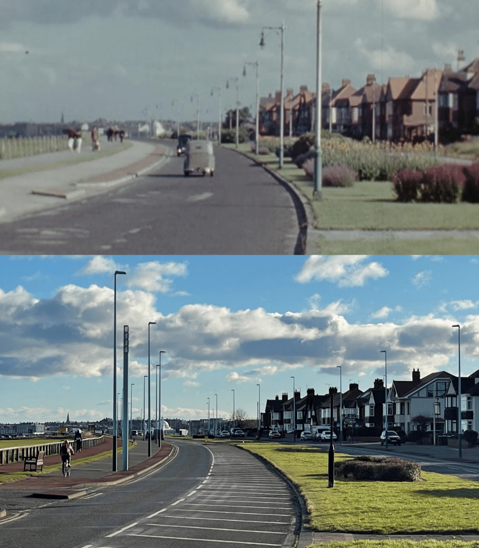
However, as with many similar proposals, the new road remained unbuilt because of WWII. According to a report in Blyth News, the dual carriageway, including cycle tracks and footways, was built and operational by May 1939. No comparable reports for the Whitley Bay section have yet been found.
Both schemes are comparatively short, with the Blyth cycleway being in Northumberland and the Whitley Bay section in North Tyneside. The boundary between the two jurisdictions is at the junction of the B1325, on the southern edge of Hartley.
As is characteristic of most 1930s cycleways, both run alongside a dual carriageway and terminate when the road becomes a single carriageway. Both are also virtually intact, on both sides of the main carriageway, and are in a reasonable state of repair. However, both are also like many other 1930s cycleways, in that they never really connected anywhere to anywhere. Partly for this reason, though also for others, observations indicate that the majority of cyclists riding along the A193 where these cycleways exist tend to use the main vehicular carriageway, rather that the separated, protected space provided by the tracks.
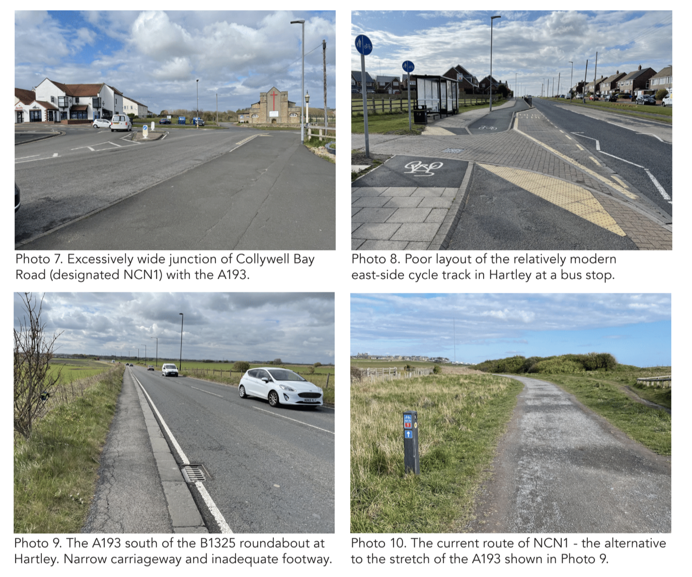
National Cycle Network Route 1 (NCN1) follows the A193 along the coast here, occasionally beingon the A193 itself, but most often (at present) running along parallel off-road paths of different character.
THE CHALLENGES
Both cycleways currently present the generic challenges typical for the 1930s cycleways. As has been mentioned, they don’t connect important origins/destinations and do not currently form part of a cycle link (or wider network) that meets LTN 1/20 standards. Other issues include the physical condition of the surface which, although much better than for many other examples (e.g. there are no major failures, encroachment or tree root damage), is only as good as might be expected from a facility that seems to have been subject to the minimum of maintenance since it was constructed (e.g. sweeping and edge trimmimg).
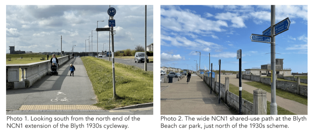
The Whitley Bay section also suffers from the generic challenge found at most side-street junctions on 1930s cycleways, which is that these flair excessively, simultaneously making the crossing distance much greater than it should be and enabling vehicle drivers to make turns in and out at speeds that increase the hazard for people cycling and walking across. Both these user groups are obliged to give way to general traffic when crossing; although there are no formal give way markings, there is no visual continuity of the cycleway or footway across the side street. The principal challenges in connection with developing these two cycleways concern how they can be joined and extended.
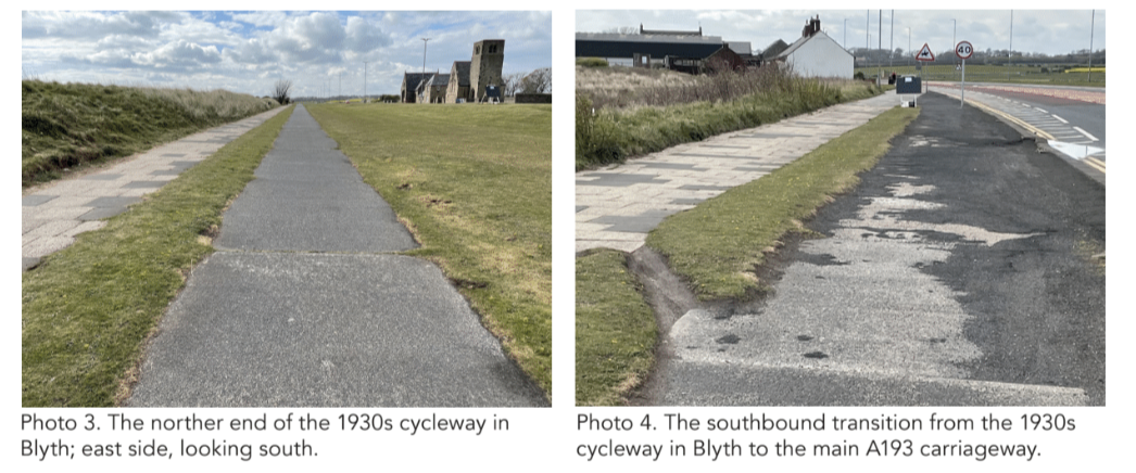
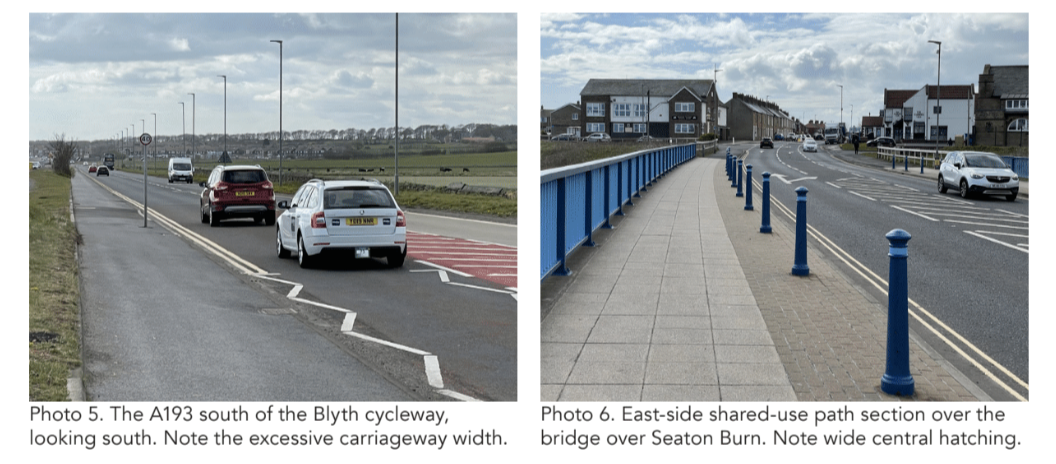
However, there seems generally to be enough space within the extents of the (A193) public highway to meet these challenges. While there are one or two pinch-points south of the Whitley Bay section, these could be resolved through modest widening using public space (The Links), not private property. There is one particular section, however, where it is unlikely to be possible to provide high quality cycling facilities in the A193, and this is the stretch from the northern end of the Whitley Bay cycleway to the roundabout junction with the B1325. The current route of NCN1 in this location is largely off-road and passes through a combined Site of Special Scientific Interest, Special Protection Area/RAMSAR, and Conservation Area. However, this challenge can become an opportunity to showcase the latest in environmentally-sensitive surfacing and lighting.
THE OPPORTUNITY
Although they comprise less than a total of 2km in themselves, the Blyth and Whitley Bay 1930s cycleways have the potential to be the catalyst for the creation of a roughly 9km long high-quality cycle route connecting Blyth and Whitley Bay via Seaton Sluice and Hartley. This link would, additionally, connect directly with a roughly 6km long cycleway between North Shields and Whitley Bay, via Tynemouth and Cullercoats, that North Tyneside Council is currently consulting on.
Together, this would represent a 15km-long (nearly 10 miles) cycle track, suitable for all, connecting all the major settlements along the coast in that area, enabling access to the beaches, leisure facilities and other attractions within the SSSI, and providing an LTN 1/20-standard route running parallel to the existing NCN1 off-road facilities (e.g. the Whitley Bay Promenade and Eve Black Way through the sand dunes between Seaton Sluice and Blyth).
The proposal is that the development scheme focuses on the creation of a single, wide bi-directional cycle track between Blyth and Whitley Bay. This would utilise the cycle track on the east side of the A193, although it is proposed that the west-side track in the Whitley Bay section is also developed.
With existing and likely future cycle traffic flows, investing in creating a cycle route on both sides of the A193 is not considered likely to represent value for money for at least another decade. A single, bi-directional track will also be much easier to fit in the section of the A193 south of the Whitley Bay 1930s section, where space is at a premium. The focus on the east side is partly because that is the side visitors to the coast will want to use, and partly because there is no frontage development on the west side of the Blyth 1930s cycleway.
It makes sense also to improve the western side of the Whitley Bay 1930s cycleway, because there is a good deal of residential development on that side, as well as three side street junctions that should not be left in their current state, inhospitable to walking and cycling across.
The possible improvements, both to the 1930s cycleways themselves and to the sections of the A193 to the north, in the middle, and to the south, are summarised as follows:
- Improved off-road link on east side of B1329 Link Road between the Blyth Beach car park and Beachway, including junction improvements to enable transition to the main carriageway for access to Blyth town centre.
- General improvements to the Blyth 1930s cycleway, including de-cluttering through the Blyth Beach car park area, and improved surfacing and widening of the historic facility on the east side of the A193. Including an improved connection with the cycle route to South Newsham and Cramlington, to the west.
- A new, separated bi-directional cycle track formed from re-purposed general carriageway on the east side of the A193, between the 1930s cycleway and Seaton Sluice.
- A new/improved, off-road, bi-directional cycle track formed to the east of the A193/A190 roundabout in Seaton Sluice, connecting with the southern access to Eve Black Way.
- A new, separated bi-directional cycle track formed from re-purposed general carriageway on the east side of the A193, between the southern end of Eve Black Way and Collywell Bay Road.
- Improvements to the A193/Collywell Bay Road junction and to the existing bi-directional cycle track on the east side of the A193 Beresford Road, as far as the B1325 roundabout.
- A greatly improved off-road connection between the A193/B1325 roundabout and via the SSSI and St Mary’s Lighthouse access road.
- General improvements to the Whitley Bay 1930s cycleway, on both sides of the A193.
- A new, separated bi-directional cycle track formed from re-purposed general carriageway, and (at pinch-points) from The Links, between the Briar Dene and the Spanish City plaza.
Euxton Lane, Euxton, Chorley, Lancashire
Location: Euxton Lane, Euxton, Lancashire
Original Length: 1.95km
Authorities: Lancashire County Council (Highway) and Chorley Council
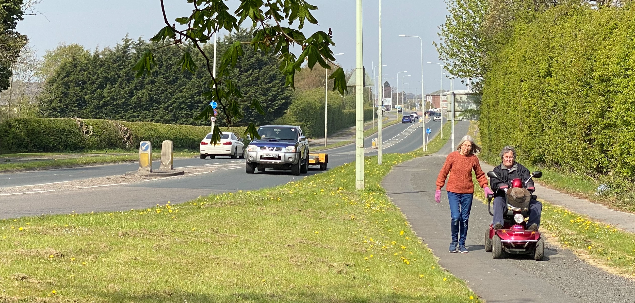
It’s hard to avoid the conclusion that the installation of the exemplary cycle tracks on Euxton Lane was in anticipation of the influx of thousands of workers that would build the adjacent factory of Royal Ordnance Force (ROF) Chorley. In January 1937, the Lancashire Evening Post reported that “With the coming of a new munitions works to Euxton, near Chorley, some very big problems have to be faced by the Chorley Corporation and Chorley Rural District Council.”
The new factory employed over 1,000 production workers by the outbreak of WWII, rising to 28,000 at the height of the war. Construction of the factory had started in January 1937, with locals complaining about the rowdiness of Irish builders, many of whom housed in ROF Huts at Leyland, an “eight mile area of isolated hutments,” according to the Post in 1939.
Euxton Lane was widened — with footways and cycle tracks included — at roughly the same time as the building of the factory. “It was stated at the monthly meeting of Chorley Town Council… that Euxton-lane, running from the Chorley-Preston main road to the Preston-Wigan road at the Bay Horse, Euxton, and passing the front of the new ordnance factory, is to be a standard width of 80 feet, and will include footpaths, dual carriageways, and cycle tracks,” reported the Post in April 1937. The 80ft width was the Ministry of Transport standard of this period for single carriageway roads, and it would seem that the 1930s cycleways alongside such roads were each just 6ft (1.83m) wide – the same as the footways – not the usual 9ft generally found alongside dual carriageways.
The 1930s cycleways on both sides of Euxton Lane extended from as far west as just east of the railway bridge that is itself just east of Euxton village, to as far east as where the junction with Badger’s Walk now exists: a total distance just short of 2km.
The typical 1930s layout had footways adjacent to the cycleways on both sides, with grass verges between both the main carriageway and cycleway and the cycleway and footway. However, on Euxton Road, this standard layout can only still be found on the north side, between the western end of the scheme and East Terrace. Based on what’s there today, however, it seems likely that the original layout along much of the route may not have been exactly to the standard.
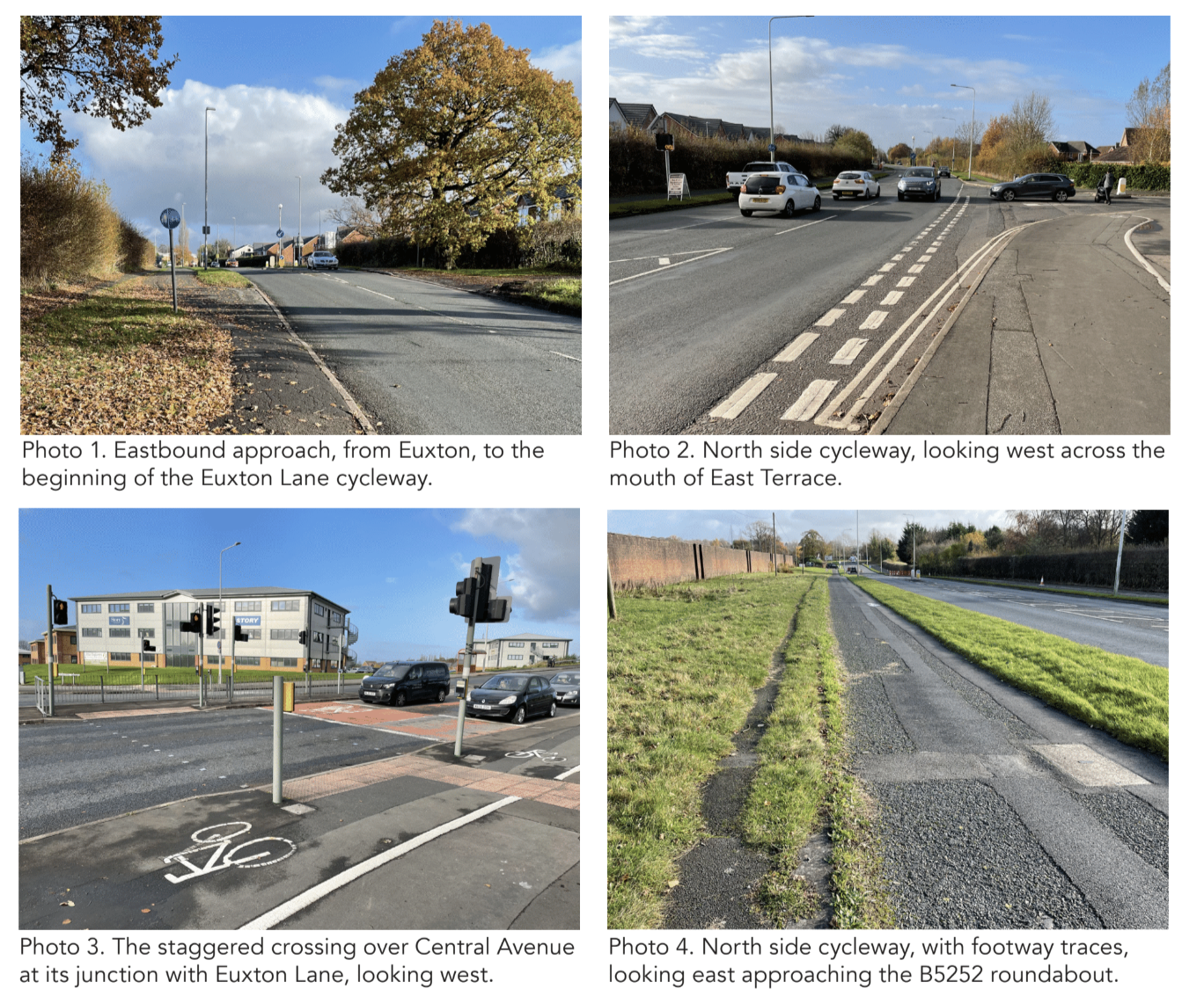
On the north side, from just west of the golf driving range junction to the eastern end of the scheme, and for the easternmost 750m or so of the cycleway on the south side, there is a kerb upstand between the cycleway and footway, not a level grass verge. Elsewhere, and largely due to substantial widening of Euxton Lane either side of the junction with Central Avenue, what were separate footways and cycleways have become single shared use paths.
To the west of the 1930s cycleways, as Euxton Lane passes under the railway bridge, the highway corridor is much narrower than further east, and the physical constraints presented by the railway bridge itself mean that extending high-quality cycling infrastructure along Euxton Lane westwards is, at best, a long-term project.
To the east, there is currently a combination of shared use paths and on-carriageway advisory cycle lanes between the eastern end of the original scheme and the new junction of Euxton Lane with the access to the Strawberry Fields Digital Hub.
East of that junction, there is a narrow shared-use path on the south side of Euxton Lane as far as the junction with the A6 Preston Road.
National Cycle Network Route 55 (NCN55) follows part of the Euxton Lane cycleway, between Central Avenue and the B5252/ Chancery Road roundabout.
On Central Avenue, NCN55 is a good standard (segregated) shared-use path that connects with Buckshaw Village.From the B5252 roundabout, NCN55 run through to Chorley via Chancery Road and AstleyPark.
THE CHALLENGES
The 1930s cycleways on Euxton Lane suffer from three principal problems that are generic for all the cycleways built in that era: they give up at junctions – even those with minor side streets; they do not themselves connect important origins/destinations; and they terminate abruptly without connecting to a wider cycling network of similar standard.
Another important issue is the physical condition of the surface. On the sections that have not been converted to shared-use paths in the relatively recent past, very few traces of the original concrete surface remain visible. However, the present surface – often what seems to be a fairly basic asphalt covering – is in a variable state of repair and does not provide a comfortable riding experience. This is in part because of general failures arising from poor maintenance, but is also due to encroachment by vegetation (the grass verges and adjacent shrubs/hedges) and occasional damage caused by tree roots.
Two particular large junctions need treatment, these being the signalised T-junction of Euxton Lane with Central Avenue (which links with Buckshaw Village) and the roundabout junction with the B5252 West Way and Chancery Road.
At the former, the cycling route along the north side of Euxton Lane is by way of a staggered signalised crossing over Central Avenue which is shared with pedestrians and involves a ‘sheep pen’ island of modest dimensions. At the B5252 roundabout, the connection between the north-side cycleway and Chancery Road (the current route of NCN52) is via a two-part uncontrolled crossing of the eastern Euxton Lane arm, with both parts (either side of the central reserve island) being two lanes wide. This is far from inviting for people on cycles.
Other challenges involve improving or creating connections between the historic cycleway and the wider network. These range from short-cuts through hedges between the cycleway and residential streets at the west end of the scheme to improvements to the quality of facilities on the eastern part of Euxton Lane, between the end ofthe historic cycleways and the A6 Preston Road.
THE OPPORTUNITY
While there is little practical scope, in the shortor medium-term, for extending the historic cycleways west to connect with Euxton village itself, there are many more opportunities along the old scheme itself, and further east.
One opportunity concerns the substantial residential area (around 250-300 houses?) on the north side of the western end of Euxton Lane, accessed by Wentworth Drive and Mile Stone Meadow. It is essentially a large cul-de-sac (collection of small culs-de-sacs) bounded by two railway lines, a business park, and Euxton Lane. This area has no direct connections to any local retail, leisure or educational facilities, and – with all properties having their own parking spaces just outside the front door – it is likely that the great majority of even the shortest trips beyond the area (all of which must go via Euxton Lane) will be undertaken by car. Yet, a large number of shops, services and employment opportunities, as well as the Trinity Primary School and Buckshaw Parkway station, are now within 1 to 1.5 miles in Buckshaw village. Runshaw College is even nearer.
Access to many attractions in Buckshaw Village is more direct by cycle than by car, as there is a shared-use path on the east side of Central Avenue, some 150m south of the Buckshaw Avenue roundabout, which is the nearest access point for motor traffic.
Comparatively modest improvements at junctions, together with the creation of a small number of new, very short, direct walking/cycling connections between the historic cycleway and adjacent sites (e.g. the College, GymWorks, and one or two of the culs-de-sac) could transform the attractiveness of cycling (and walking) for these short, everyday trips.
The Euxton Lane cycleway also forms the core element of what could be a high-quality cycling route between Buckshaw Village (and Euxton Village) and the Chorley and South Ribble Hospital. Although the historic route terminates around 600m west of the main hospital entrance, and around 800m west of the junction with the A6, there is a shared-use path on the north side of Euxton Lane as far east as the new access to the Strawberry Fields Digital Hub, and on the south side of Euxton Lane for the full distance between Badger’s Walk and the A6. (Somewhat curiously, there is also an advisory cycle lane in the main carriageway, in both directions, between Badger’s Walk and the Strawberry Fields junction.)
Both of the shared use paths could be appreciably improved in terms of the level of service they provide to people both walking and cycling, at relatively low cost and with minimal effect on general traffic capacity.
Bearing in mind current and likely future levels of use, and the importance of ensuring value for investment, it is recommended that the emphasis of works to improve the historic features should be on creating a high-quality bi-directional cycle track on the north side. The north is preferred to the south on the grounds of there being a greater number of destinations on the north side: Buckshaw Village and station, the College and the Wentworth Drive residential area. The south side is not to be ignored, however, there being on that side new homes around Stansfield Drive (to the west) and Mimosa Close (to the east), and the existing alignment of National Cycle Network route NCN55, which currently runs from Euxton Lane to central Chorley via Chancery Road and Astley Park.
On the south side, though east of the historic scheme, there is also the Chorley and South Ribble Hospital. Extending the benefits in terms of adding real value to any upgrade of the 1930s cycleways on Euxton Lane themselves, the obvious opportunity is to improve the quality of cycling facilities on the easternmost 800m of Euxton Lane, connecting past the hospital to the A6 Preston Road.
In due course, conditions for cycling could also be improved on the 1.5km route between the Euxton Lane/A6 roundabout and Chorley town centre, via the A6/Preston Road and A581/Park Road. The current designated cycle route between Euxton Lane and Chorley town centre is via NCN55, which runs along Central Avenue past Buckshaw Village, part of Euxton Lane, and then via Chancery Road and Astley Park. While this route is acceptable for low volumes of leisure cycling, it is far from direct and the narrow shared-use path on Chancery Road creates conditions that are comparatively poor for people both on foot and on cycles. Moreover,the route through Astley Park is not well-lit and cannot be considered suitable for everyday cycling throughout the day and year.
It is understood that improving cycling conditions on the Preston Road-Park Road link has been explored relatively recently, with the conclusion having been reached that traffic capacity concerns would make it difficult to introduce good quality cycle facilities on the A6 section in the short-term.
There is some existing provision for cycling on Park Road: shared-use paths on both sides of between the entrance to Astley Park and Rectory Close; advisory cycles lanes on both sides between Rectory Close and Commercial Road; a northbound advisory cycle lane Commercial Road and the A6. There is clear scope and opportunity to improve the quality of these facilities in line with Local Transport Note 1/20.
On the A6/Preston Road section of the route, there is currently only a southbound advisory cycle lane on part of it. There is scope for much better, however, and options to improve cycling facilities on this stretch can be developed in the light of the Government’s Net Zero Strategy, Lancashire’s Climate Change Strategy (to 2020), and Chorley Council’s pledge to work to make the Borough carbon neutral by 2030.
A full schedule of possible improvements, principally to the 1930s cycleways themselves but also to the easternmost 800m of Euxton Lane, is summarised as follows:
- On the north side, between the western end of the 1930s scheme and East Terreace, re-use the available space (about 7m in total), to create a 2m footway and 3m bi-directional cycleway, separated by a kerb step or a 0.5m grass verge. Maintain a 1.5-2.0m grass verge between the cycleway and main carriageway. Modify junctions with Wenworth Drive and East Terrace to provide walking and cycling priority across, as per LTN 1/20. Remove bus stop layout.
- On the north side, between East Terrace and Central Avenue, in the short term improve the ‘segregated shared’ arrangement by installing a tactile delineator strip between the footway and cycleway. In the long term, remove the dedicated left turn general traffic lane and reuse the space to provided separate, protected footway and cycleway.
- On the south side, between the west end of the 1930s scheme and Central Avenue, re-use the available space (about 7m), to create a 2m footway and 3m bi-directional cycleway, separated by a kerb step or a 0.5m grass verge. Maintain a 1.5-2.0m grass verge between the cycleway and main carriageway.
- Modify the Euxton Lane/Central Avenue signalised junction to reduce vehicle speeds on turns and create wider islands on both north and west arms to enable comfortable straight-ahead (though still two-stage) crossing by people walking and cycling.
- On the north side, between Central Avenue and the West Way/Chancery Road roundabout, modify the existing layout to provide separate 2m footway and 3m bi-directional cycleway. Modify side junctions to provide walking and cycling priority across, as per LTN 1/20. Modify bus stop layouts as necessary.
- Replace the informal crossing of the east arm of the West Way/Chancery Road roundabout with a two-stage Toucan crossing; widen the central island (narrowing eastbound exit lane); and renew the ‘segregated shared’ path through the crossing.
- Between the West Way/Chancery Roadroundabout and the eastern end of the 1930sscheme, on both sides, resurface/repair/widen the cycleway (3m), footway (2m) and separatingkerb step; cut back encroaching vegetation. Between Badger’s Walk and the new signalised junction with the Strawberry Fields business park, reuse the existing shared-use footway on on-carriageway advisory cycle lane space (around 4.5m) on both sides to create a 4m shared-use path with a 0.5m grass verge and kerb separating from the main carriageway.
- Remodel the Strawberry Fields business park junction to provide much better facilities for people walking and cycling.
- Between the Strawberry Fields business park junction and A6 roundabout, focus attention on achieving the best possible walking and cycling facilities on the south (Hospital) side, repurposing a general traffic lane, if necessary to create LTN 1/20-compliant conditions.
Formby Bypass, Formby, Sefton
Location: A565 Formby Bypass, Formby, Sefton, Merseyside
Original Length: 6.15km
Authority: Sefton Council
The dual carriageway bypassing Formby was opened with great civic pride at midday on Saturday, December 17th 1938. The bypass was considered such a marvel that Lancashire County Council produced a 16-page commemorative brochure for the opening, at which the Earl of Derby, Lord Lieutenant of Lancashire, gave a ribbon-cutting speech to a “large assembly.” Alderman P. Macdonald, the vice-chairman of the County Council’s highways committee, said the bypass was “laid out on the most modern lines and constructed according to the requirements of the Ministry of Transport”. Indeed, it was the Ministry that stipulated that the road should have cycle tracks, it having been initially planned in 1928 as a narrower road without them. Interestingly, a traffic census conducted on the old road – the findings of which were included in the brochure – counted 530 cyclists in 1928, and 2,291 in 1938, a four-fold increase. In the same period, motor-car use had only doubled.
Reported in the Formby Times on the day of opening, Macdonald said the bypass has “two carriageways with a central reservation and a cycle track on either side, along with a good footpath.” He added, “By this segregation of traffic (I hope) that accidents will be reduced, that the flow of traffic will be facilitated, and the comfort of users will be added to.”
The brochure describes the near four-mile-long road as 120 feet wide with dual carriageways 22 feet wide. There was also a central reservation of 22 feet and “cycle tracks nine feet wide and footpaths six feet wide, with grass margins.” The brochure also stated that the bypass cost £195,483, “towards which the Ministry of Transport indicated a grant of 60% on 17th April, 1936.”
Work commenced on April 9th 1937 and the bulk was completed by September 1938. The brochure is a treasure trove of construction details.
“The near side kerbs joining the cycle tracks are 10 inches by four inches and are laid directly on the extremity of the concrete carriageway slabs.”
The cycle tracks were constructed with “6 inches consolidated foundation of clinker ballast covered with a binder course of tarmacadam [one and a half] inches thick over which is laid a [three-eighths inch] layer of sand carpeting, squeegeed with bituminous compound and covered with [threesixteenths of an inch] gauge green chippings evenly distributed and lightly rolled to produce a matt, non-skid surface finish.
“The near-side concrete kerb of the cycle tracks is set sufficiently low to prevent cycle pedals from coming into contact with it. And the offside timber kerb is fixed flush with the surfaces of the cycle track and adjacent grass margin so that it can be overrun in the case of an emergency.
“The footpaths are constructed in a similar manner to the cycle tracks, except that the foundation of clinker ballast is three inches thick and the squeegeed surface of the sand carpeting is covered with half inch gauge pink chippings.”
The Formby bypass is one of several roads with adjacent cycle tracks constructed in Lancashire in the 1930s. Indeed, in the 1930s and through to the 1950s, Lancashire was the most active road-building county in the country, chiefly due to the initiative of Sir James Drake, the County Surveyor.
The council’s Preston Bypass, opened in December 1958 and long advocated by the then-retired Drake, was Britain’s first motorway.
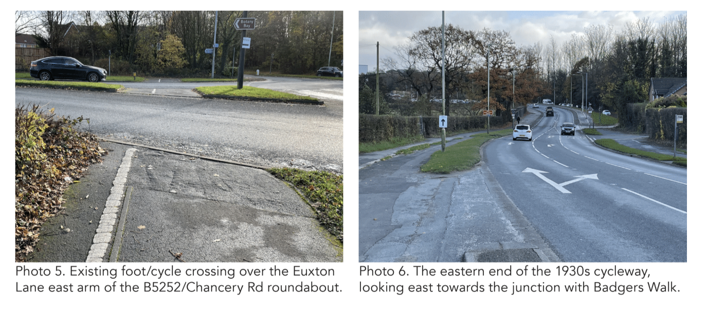
The 1930s cycleways ran north-south for over 6km from the junction with Southport Old Road – just south of what was the Chesire Lines Railway corridor and what is now the alignment of Moor Lane and Coastal Road – to a point a little south of North End Lane/New Causeway.
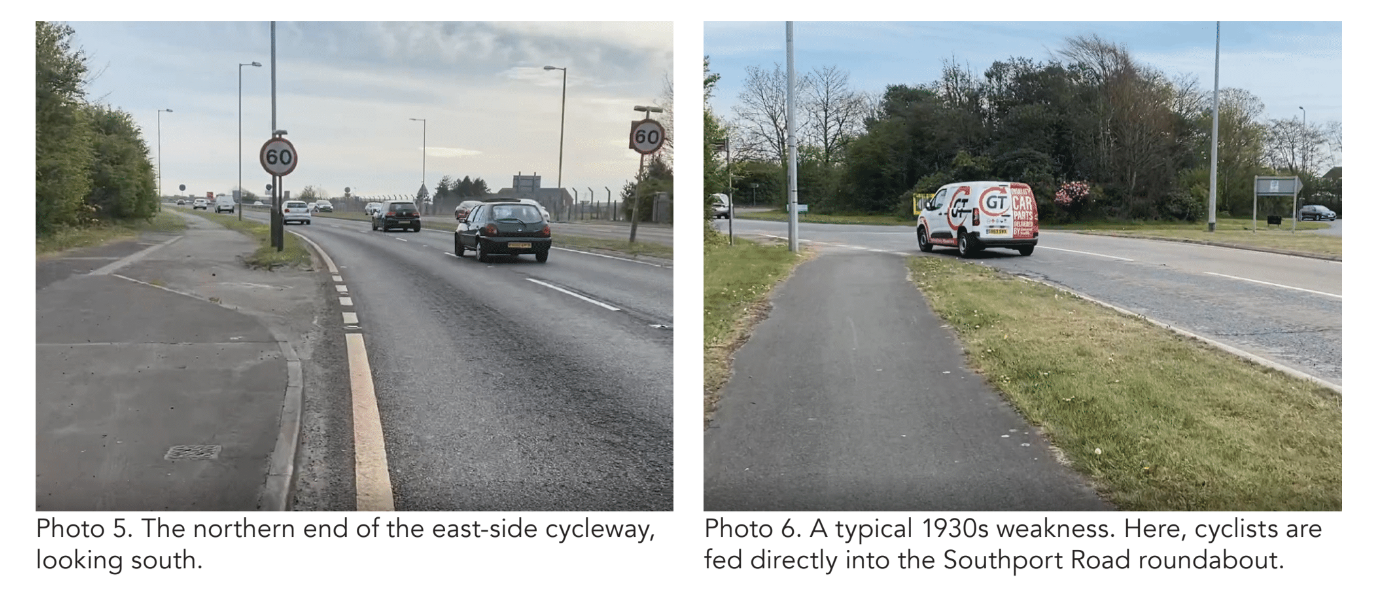
At the south end, in a manner typical of 1930s cycleways, the cycleway simply peters out in the middle of nowhere. Accordingly, the focus of this initiative is on the northernmost 4.9km of the scheme, as far south as far south as the roundabout junction with the B5424 Liverpool Road.
A great deal of new development has happened and is happening in that southern section, and this is one of the reasons why bringing the 1930s cycleways back to life has such potential.
THE CHALLENGES
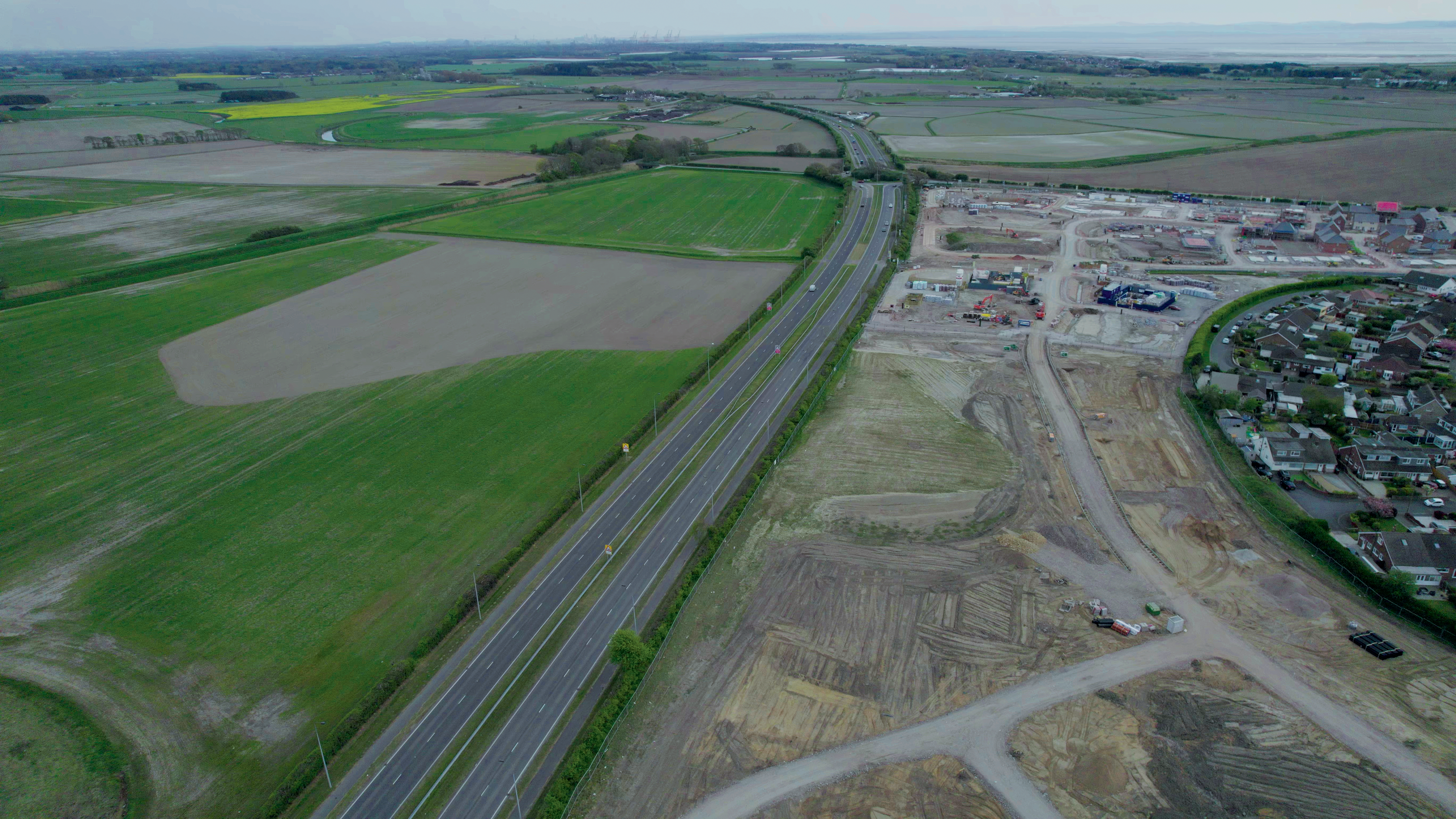
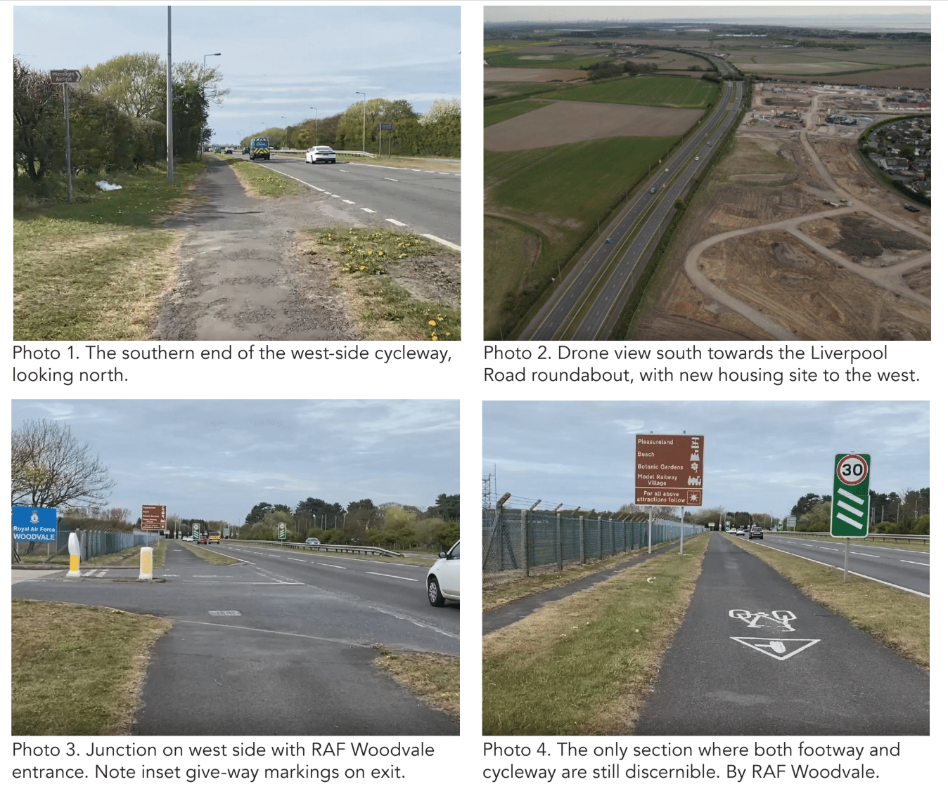
As described above, the original layout of the cycleways and footways adjacent to the bypass was as per the Ministry’s highest standard: a 6ft footway and 9ft cycleway on each side, separate from one another and the main carriageway by grass verges. However, today, there is only one short section where both the footway and cycleway can separately be seen – for about 320m on the west side, immediately north of the entrance to RAF Woodvale.
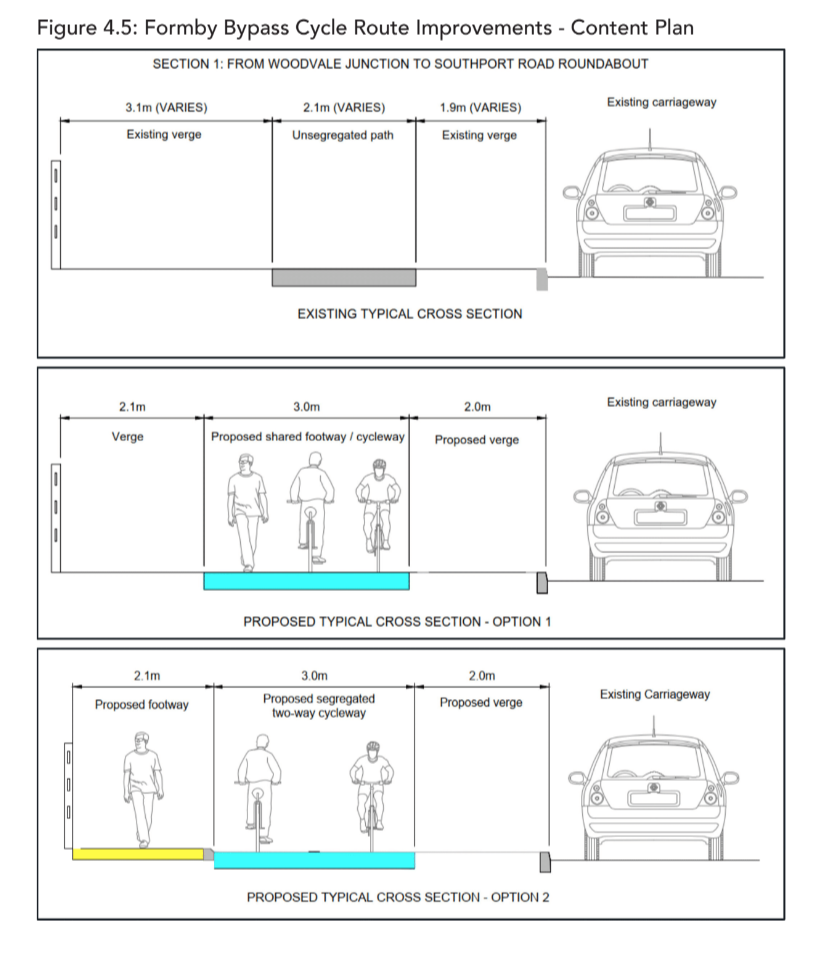
The dual carriageway and central verge have not been widened materially, however, it is simply that, over time, the separate footway, cycleway and verges (totalling around 7m) have become merged so that there is now, on both sides of the road, just a single shared-use path around 2.5m wide with very generous grass verges either side.
The Formby cycleways also suffer from two of the classic flaws of the 1930s schemes: they never formed part of a coherent cycling network and, at the southern end at least, they simply stop in the middle of nowhere. Like many other 1930s schemes, the Formby cycleways were not built to serve any specific places where people might want to cycle to or from – they were just created either side of a new road.
And given this the road was a bypass, its chief purpose was to avoid places where people were.
Because the original foot and cycleways have been so modified, and also because of their extra-urban location, another common flaw – that of poor physical condition, often compounded by tree root damage – is not a major issue. That said, being alongside a busy, high-speed road (60 mph) means that the existing paths are subject to being sprayed with gravel and other fine material.
Lamp columns present a possible impediment to widening. The character of the location also means that cycling alongside the Formby bypass is not badly affected by numerous interruptions at side streets (the design of which is another classic problem). However, in common with seemingly every other 1930s scheme, the cycleways simply terminate at major junctions, directing cyclists into the main carriageway. People on foot – several of whom were observed on a site visit – simply have to manage as best they can.
THE OPPORTUNITY
In many respects, it might be thought surprising that there is any meaningful opportunity here. What would be the point of improving cycleways on a bypass located away from where people live and work? Well, there wouldn’t have been a point a few years ago, but times change. A large number of homes have been and are being built immediately adjacent to the A565, and more are planned. Other destinations have also cropped up in recent years, including a Tesco superstore and adjacent employment area on the east side of the junction with Altcar Road. As a result, Sefton Council has already begun to develop plans to improve the quality of the historic cycling facilities alongside the Formby Bypass, to enable people to travel to and from such origins and destinations as these.
Improvement plans are proposed to begin at the north and work south in successive stages. In addition to serving recent and new development, these improved cycling and walking facilities also present the opportunity to upgrade the National Cycle Network.
The existing NCN810 runs roughly parallel to and 1km west of the A565, while just a very short extension at the the northern end of the 1930s scheme would enable it to connect with NCN62.
However, north of Formby, NCN810 is unlit and there is a rough track that is in poor condition for much of the year.
A new route from Formby town centre via part of the 1930s scheme would provide better 24/7/365 connection between NCNs 810 and 62.
Developed by consultants for Sefton, there are two given options for upgrading the cycleways in northern section, and these are also applicable further south. Work is also in hand to create the short link at the north end to NCN62, and to explore significant improvements to the small number of major junctions.
Hilton Road + Harpfield Road, Stoke-on-Trent
Location: Hilton Road and Harpfield Road, Stoke
Original Length: 1.4km
Authority: Stoke-on-Trent City Council
Not a great deal is yet known about the history of the cycleways on Hilton Road and Harpfield Road, beyond that they were installed some time after 1935. In September of that year, the *Staffordshire Sentinel reported that: “Following a letter from the Ministry of Transport stating that the Minister had decided to make available increased grants for works of improvements on Class 1 roads where the provision of dual carriageways and cycle tracks was made, the Highways and Plans Committee recommended that the Ministry be informed that, in connection with the scheme already submitted for the 80ft Harpfield bypass road, the committee were prepared to consider proceeding with the full width construction, including dual carriageway and cycle tracks.”
In keeping with many other 1930s schemes, Hilton Road and the section of Harpfield Road that has original cycleways are dual carriageways. However, they are comparatively narrow examples of this layout, and the central reservation is generally only 1m wide. Indeed, 80ft was generally the standard Ministry of Transport width of a single carriageway road at the time. Accordingly, it would seem, the cycleways in Stoke are each just 6ft (1.83m) wide – the same as the footways – not the usual 9ft. Plainly, this will have an effect on how they might best be developed to form part of a high-quality contemporary cycling network.
In both the Hilton Road (north) and Harpfield Road (south) sections, the carriageway on each side of the narrow central reservation is around 6.1m (20 ft) wide. This is enough for two running lanes in each direction, but the space is now generally laid out as nearside parking lane and a single running lane (around 3.8m wide).
The northernmost part of the scheme is on Hilton Road, roughly 80m north of its signalised junction with Ashlands Road (east arm) and the access road around the north of the Royal Stoke University Hospital (west).
As things are today, Hilton Road simply becomes Albany Road at the point, going north, where the street narrows to a single carriageway.
Historic mapping shows, however, that Hilton Road previously extended a little further north to a junction with Albany Road, Longfield Road and another street called Broadway (now Fosbrooke Place). North of Ashlands Road, the cycleway is now absent on the west side of Hilton Road. South of that junction, however, the historic layout is present on both sides of the road.
The quality of the surface varies considerably. Between Ashlands Road and the roundabout junction with Newcastle Lane, the land use on the west side of Hilton Road is related to the hospital in one way or the other, be that medical facilities, staff accommodation, or car parks.
The east side, by contrast, is predominantly residential, and this brings with it issues related to vehicular access to domestic forecourts. At the Newcastle Lane roundabout, as is characteristic of the 1930s schemes, the cycleways simply terminate with short ramps to/from the main carriageway. There is clearly space, however, within which to create a layout that gives much greater protection and priority to both walking and cycling.
Newcastle Lane marks the division between Hilton Road and Harpfield Road, and the 1930s scheme on the latter extends approximately 630m further south, to the junction with Woodberry Avenue (east side). Unfortunately, the southernmost 70m of the west-side cycleway was destroyed, some time between 2015 and 2018,by carriageway widening undertaken to create a nearside parking lane.
Between Woodberry Avenue and the six-arm Keelings Drive/Withies Road/Sutton Drive roundabout (approx 350m), Harpfield Road is a two-lane a single carriageway, with cycling and walking provided for by a roughly 3.5m-wide ‘segregated shared-use’ path on each side.
The highway is around 24m between property boundaries. The paths are separated from the carriageway by a roughly 3m-wide grass verge that also contains trees at approximately 12-15m centres, and there is also a grass verge between the paths and the property boundaries.
Parking seems commonplace in the path on both sides, as well as in the planted verge.
Between Keelings Drive and the A34 Newcastle Road/Flash Lane junction (around 325m), there is also a ‘segregated shared-use’ path and tree-planted verge on both sides. The overall highway width is narrower (around 20m), however, and this means that the paths are somewhat narrower than further north, too (no wider than 3m).
The absence of a grass verge between the paths and the property boundaries further reduces the effective width of the ‘segregated shared-use’ paths, which are hard up against boundary walls.
Flash Lane forms a junction on the east side of Harpfield Road immediately north/east of the junction with Newcastle Road where Harpfield Road ends.
A narrow bi-directional cycle route is marked in paint on the spur of footway between Flash Lane and Newcastle Road, and this connects with a roughly 3m-wide cycle path (signed as shared-use) that runs through a grassy space for around 50m to reach a Puffin crossing of Newcastle Road. It is here that the cycle route along Hilton Road and Harpfield Road can be said definitively to have its southern end.
THE CHALLENGES
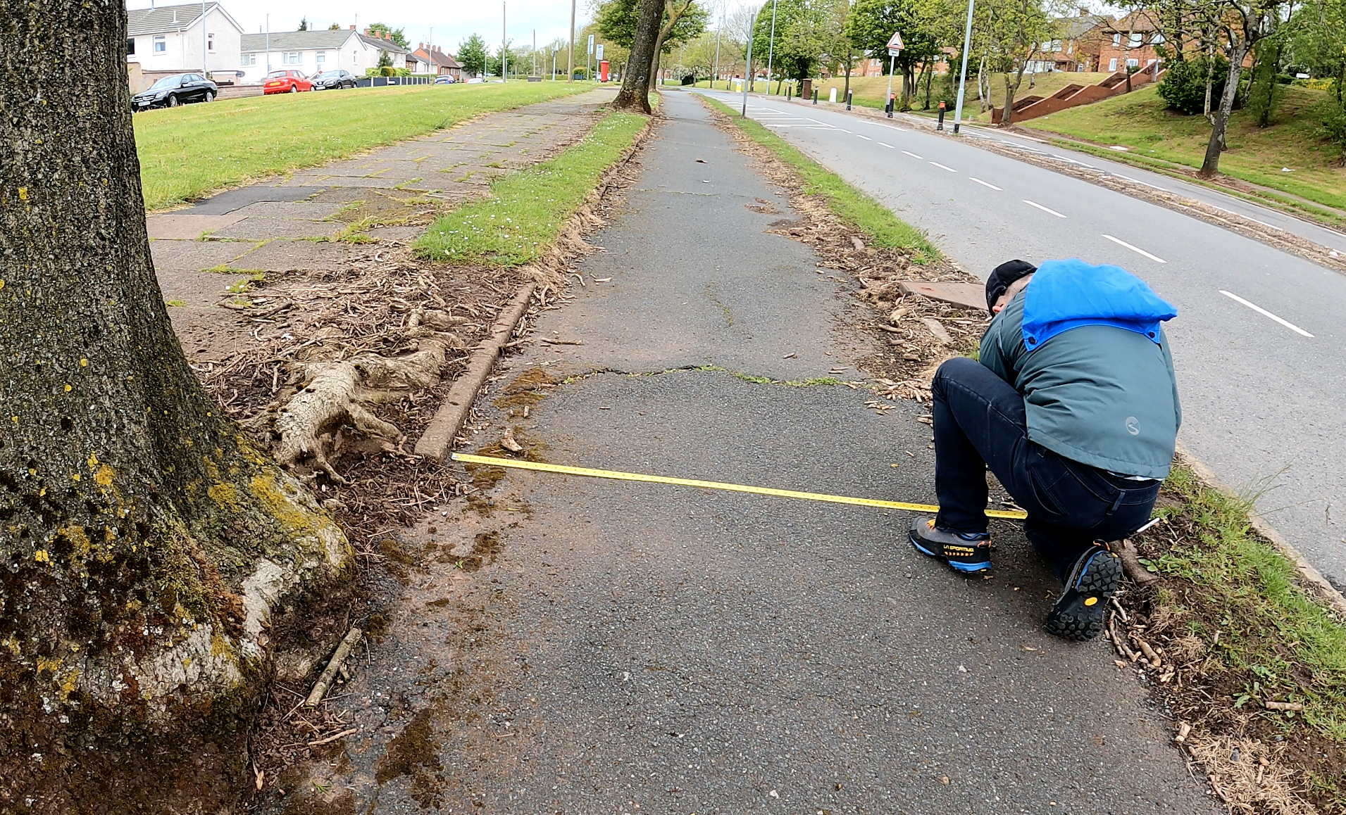
One of the chief drawbacks in seeking to develop the 1930s cycleways on Hilton Road and Harpfield Road is that fact that they were originally 6ft wide, the same as the footways,not the 9ft common with other schemes. This means that they are too narrow to be used for bi-directional cycling, which would usually be considered best in the context of a dual carriageway. That said, with there being only a single running lane (plus a parking lane) on each side, a 30mph speed limit and a very narrow central reservation, and numerous breaks, it is comparatively easy for people on cycles to cross from one side to the other. Other challenges are typical of many other 1930s-era cycleways: a rough/broken surface (due to general lack of maintenance and tree root damage); narrowing due to encroachment of the grass verges; and lack of sweeping.
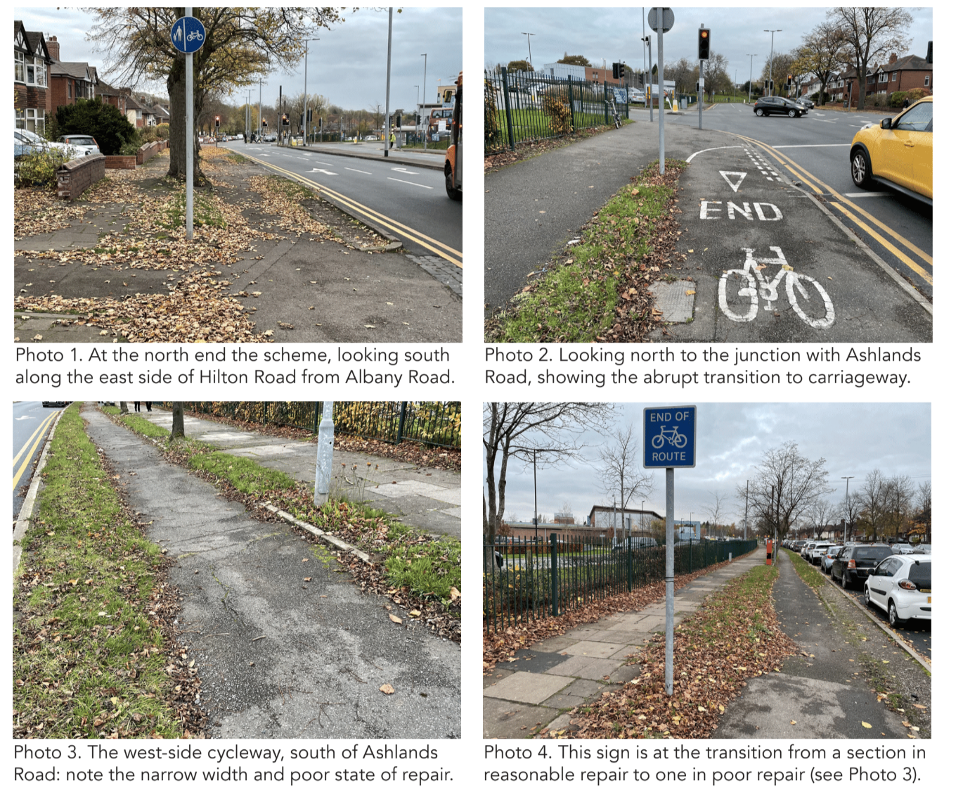
There are also the classic issues of numerous poorly designed side street junctions and of the cycleways simply giving up at major junctions. There are three of the latter: the signalised junction at the north end with Ashlands Road; the central roundabout with Newcastle Lane; and the roundabout with Keelings Drive to the south of the 1930s scheme.
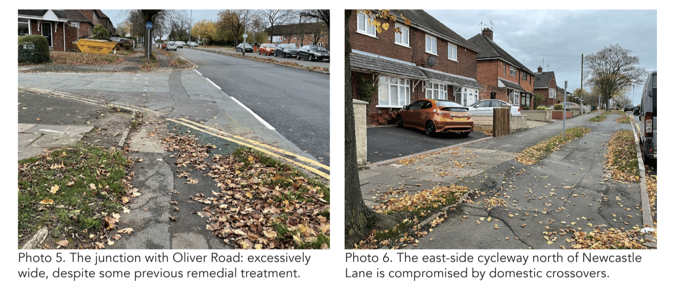
As for side streets and other side accesses (e.g. for car parks), there is a total of eight junctions within the historic scheme where walking and cycling priority across is a problem. Previous attempts have been made to address this problem, with the cycleway marked in green across the mouth of some junctions, and give way markings behind this marked path on exit from some side streets. However, the basic geometry – the mouths of the junctions being too wide and turn radii too large – remains an inherent problem.
A further five such junctions between the southern end of the 1930s scheme and the A34 Newcastle Road.
The link between the south of the original scheme and the A34 is itself another challenge. There are currently walking and cycling facilities on both sides of this narrower, roughly 700m-long single carriageway section. However, they are in the form of ‘segregated shared-use’ paths that provide a poor level of service for all users. Moreover, there seems to be much greater demand for residential parking on-street in this southern section, and this will also be a challenge to resolve.
THE OPPORTUNITY
One of the problematic characteristics of many 1930s schemes is not a problem with the Stoke scheme: that of the cycleways being in the middle of nowhere and/or not connecting any important destinations. In this case, the cycleways not only run through a large residential area but also link it with the Royal Stoke University Hospital (at the north end of the scheme) and a number of satellite health facilities, and with a large employment area, a few hundred metres south of the junction of Harpfield Road with the A34.
Even though the latter is dominated by several large distribution warehouses, it is nevertheless home to many jobs, as – of course – is the hospital.
At all three of the large junctions along the route (including the Keelings Drive roundabout which is south of the original scheme), there is ample space to modify the existing layouts to create much better conditions for walking and cycling.
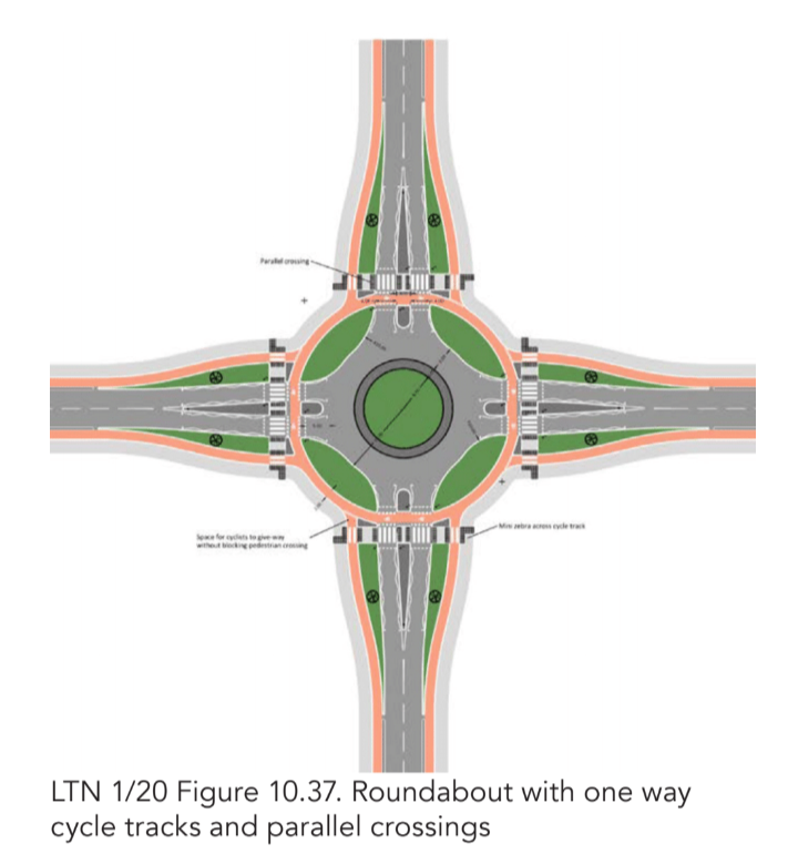
The Newcastle Lane roundabout could, for example, be remodelled. In addition, due to comparatively low traffic speeds and volumes, the constraints on improving side street and car park junctions are minimal.
There is also the simple fact that the space occupied by the original cycleways, footways and verges has not been encroached upon to any significant extent as a result of any carriageway widening or other measures. Some of the bus stop arrangements need to be modified, but there are no physical limitations on doing so. Moreover, there is a great deal of on-street non-residential parking, along Hilton Road in particular, and some of this could be repurposed should the space be required for other uses such as build-outs for crossing points, bus stop facilities, or even cycleway widening. Extending the Benefits There is plainly a promising opportunity to connect the 1930s cycleways south from their original end-point near Woodberry Avenue to the A34.
As stated above, to achieve high quality cycling and walking conditions on this stretch will not be without its challenges, but there is scope to make an appreciable difference.
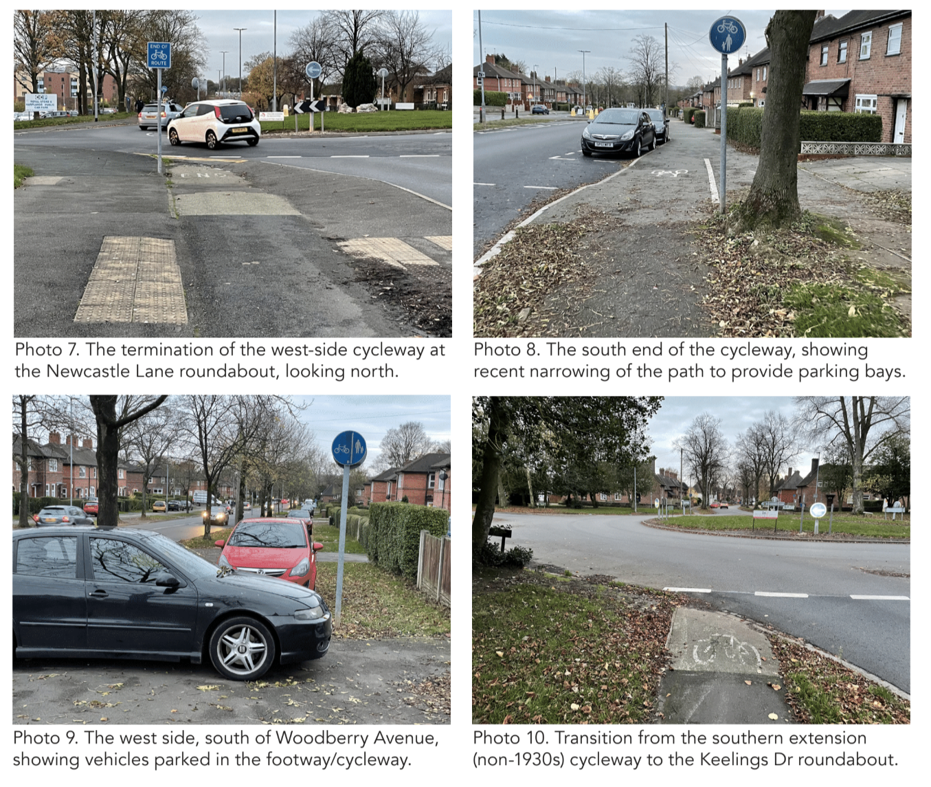
While the grass verges with often fine mature trees should generally be considered a fixed constraint, some protected space for cycling (in one direction) could be reclaimed from the carriageway, and the ‘segregated shared-use’ paths on either side could be improved to provide a much better level of service than currently. They could be widened to their maximum extent, relaid by machine to create a smooth surface, and provided with better transitions to/fromnthe carriageway.
If maintained as ‘segregated/shared-use’, the segregation should be provided in the form of a regulation tactile delineator strip, not just a painted line.
At the southern connection with the existing cycling facilities on the east side of the A34, a new parallel foot/cycle crossing should be provided just to the north of the side junction with Flash Lane, while that junction should be narrowed substantially to reduce vehicle speeds and create shorter crossing distances.
Further works to improve cycling facilities along the A34, linking to the employment area, should be pursued in due course.
Arnold Road, Nottingham
Location: B6004 Arnold Road, Nottingham
Original Length: 1.2km
Authority: Nottingham City Council
The 1940s aerial layer of Nottingham City Council’s Insight Mapping shows the cycleways and footways beside the Arnold Road dual carriageway. They were probably installed sometime between 1937 and 1939 when the City Council built several stretches of cycleway alongside a number of Nottingham’s arterial roads.
According to the Nottingham Evening Post in 1937, the “first highway [in Nottingham] to incorporate separate cycle tracks on each side is now in course of construction, and considerable progress has been made.”
The highway in question was Middleton Boulevard, linking with University Boulevard.
“It is anticipated that the present section… may be completed by next summer, and the distance from Dunkirk to Mansfield-road, via Western-boulevard and Valley-road will be five miles,” said the report.
“The special cycle tracks, which the Ministry of Transport insisted upon,” the Post added, “will be 9ft wide, and will be separated from the footpaths and carriageways by grass strips 5ft 6ins wide. Footpaths will be 10ft wide, and the dual carriageways 20ft in width, divided by a central grass plot of similar dimensions.”
Unlike Middleton Boulevard, however, the 1.2km section of Arnold Road alongside which separate footways and cycleways were constructed is, and has always been, a single carriageway. Although the basic layout visible today is very familiar from other 1930s schemes – a parallel footway and cycleway on each side of the main carriageway, and grass verges separating the cycleway from both the carriageway and footway – it would appear that the original dimensions of the cycleway and footway may not have been the standard 9ft and 6ft. Much may have happened in the past 80 or so years to modify the original layout, of course, but the widths visible today seem fairly consistently to be more in the order of 8ft (2.44m) and 4ft (1.22m).
Of course, the key issue is not what these widths were, or are, but what they might be. To that end, the verges either side of the cycleways, together with that often also present between the footway and property line, provide scope for appreciable widening, if necessary. The western end of the original scheme seems to have been just east of the junction of Arnold Road with the A611 Hucknall Road, more or less at the junction with the western end of Gainsford Crescent (which also forms a junction with Arnold Road some 600m further to the east).
The eastern end of the scheme was just west of the junction with Edwards Lane. The latter was a T-junction in the 1930s, but a northern extension to Edwards Lane has since been built, creating a crossroads. Apart from two short shopping parades, the fronting development is almost entirely residential.
Much of the latter post-dates the 1930s, and indeed 1950s mapping shows the north side of the road to have very little built frontage. The large area enclosed by Arnold Road and Gainsford Crescent, for example, though now filled by houses either side of Pavior Road, was then Playing Fields. The dwellings are largely two-storey houses, but some of the more recent stock is in the form of three-storey flats.
Another characteristic of this stretch of Arnold Road is that the dwellings are generally set well back from the carriageway, and often with a separate access road between. This layout may have something to do with the fact that there is a notable fall in ground level from north to south, across the east-west axis of Arnold Road. Also of interest is the fact that the large Nottingham City Hospital campus lies a shortway due south of the section of Arnold Road in question, and is also bounded to west and eastby Hucknall Road and Edwards Lane.
THE CHALLENGES
One of the main challenges faced in making good, contemporary use of the 1930s cycleways on Arnold Road is the fact that the scheme never did engage properly with the junctions at either end. This is characteristic of the 1930s schemes, meaning that the cycleways simply stop short of the Hucknall Road and Edwards Lane junctions – both of which are signalised crossroads today.
Another typical flaw is that the cycleways give up at junctions with side streets, and the challenges related to this are magnified on Arnold Road because the presence of parallel service/access roads has lead to many side junctions being excessively wide. Not all of the junction layouts are 1930s originals.
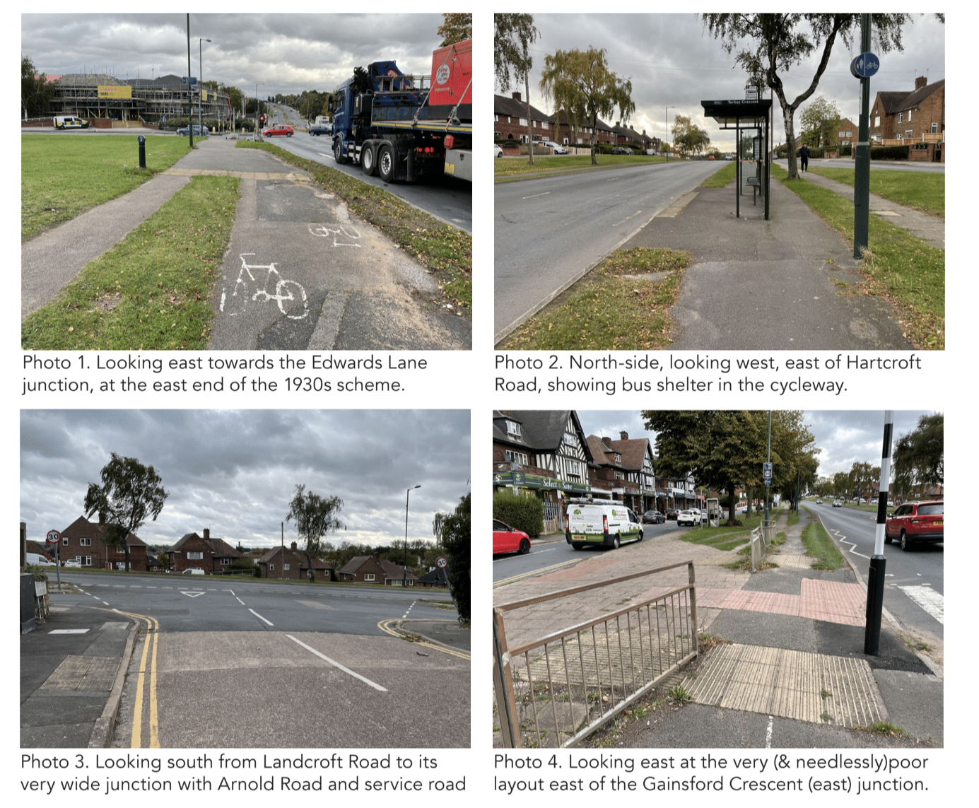
The roundabout junction with Pavior Road dates from later than the 1950s, and its creation not only made a break in what was originally a continuous cycleway on the north side but also diverted the cycling and walking routes well off the natural desire line, which was originally catered for.
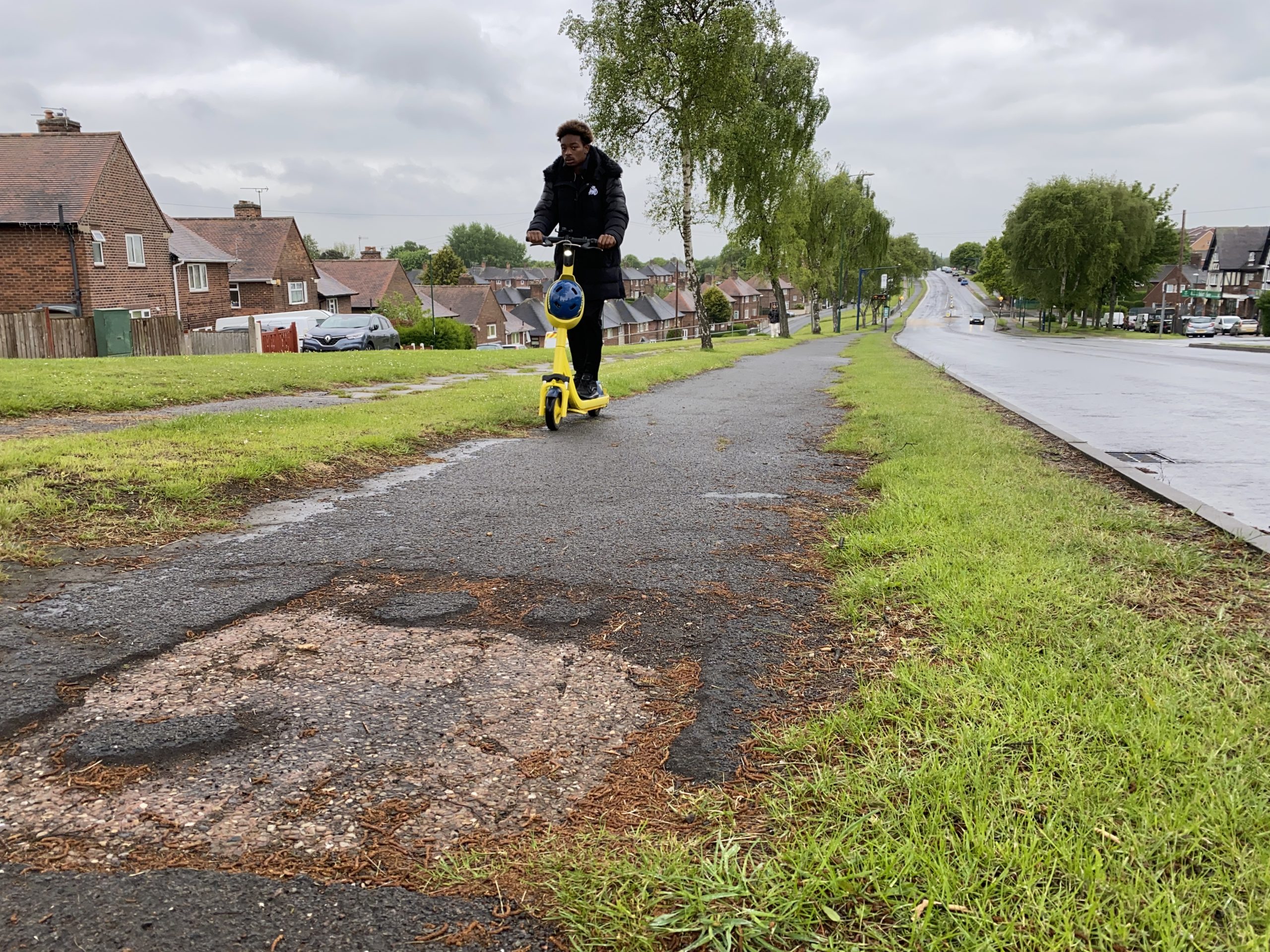
The general condition of the Arnold Road cycleways is also a cause for concern, with many sections being in a poor state of repair, there being numerous obstacles (like railings and statutory undertakers’ boxes), and encroachment of the grass verges having reduced the effective width of some footway and cycleway sections well below what provides an adequate level of service.
Another challenge, though straightforward enough to address, is the layout at bus stops, with some shelters unnecessarily obstructing the passage of people on cycles.
THE OPPORTUNITY
Notwithstanding these challenges, the fact is that, between Hucknall Road and Edwards Lane, the legacy of the 1930s scheme is that there is more than adequate space to create excellent provision for walking and cycling on both sides of the road, without needing to take any appreciable space currently used for moving or parked vehicles.
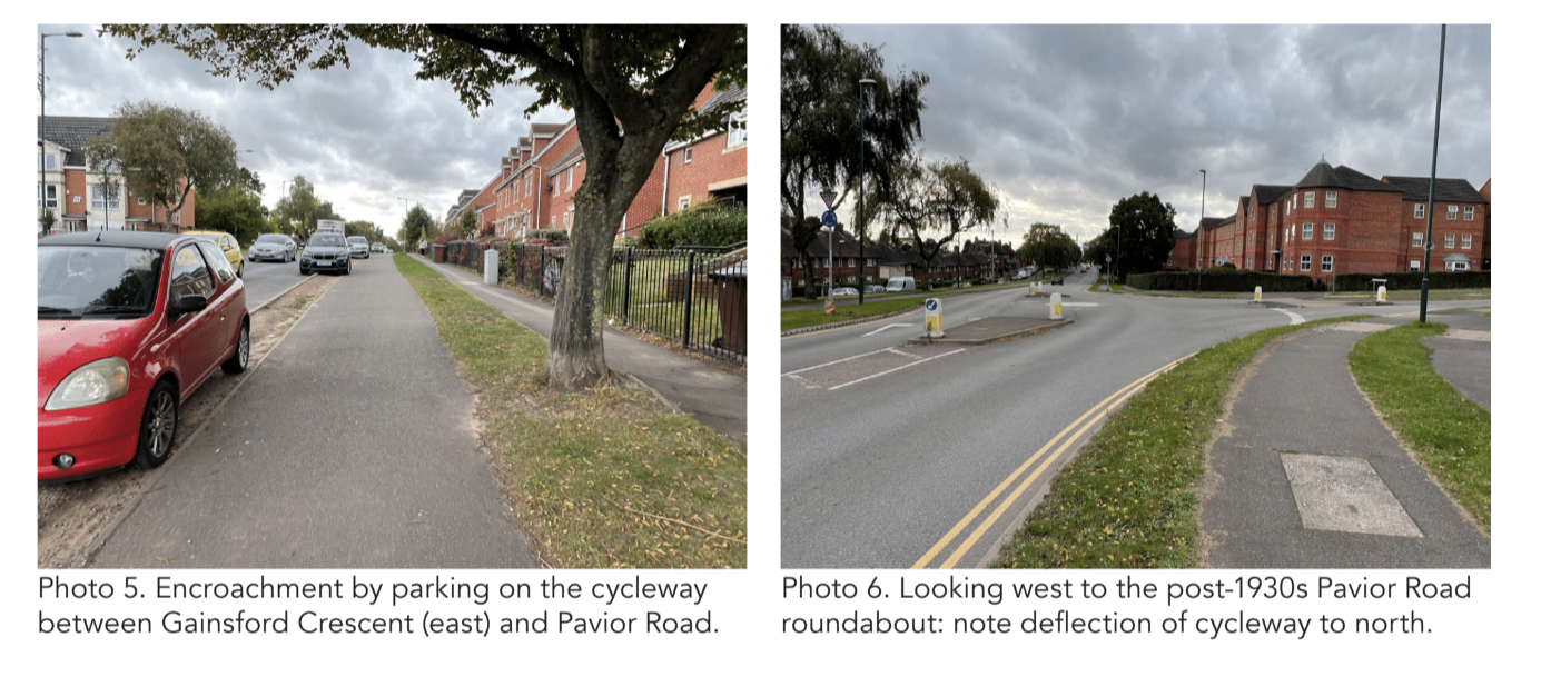
The fact the road has a large number of homes close by on both sides, that it contains local shops, and that it runs close to the City Hospital means that there is a wide variety of local journeys that could make use of these facilities.
A comprehensive improvement programme to return the footways to their original width, modestly widen the cycleways by repurposing part of the verge, modify the bus stop layouts, and generally resurface and de-clutter would make huge difference in itself and is not constrained by the availability of space.
As for the junctions at each end, there is space to remodel the Edwards Lane signals to provide good priority and safety for walking and cycling; while the City Council already has proposals for improvements at the Hucknall Road end.
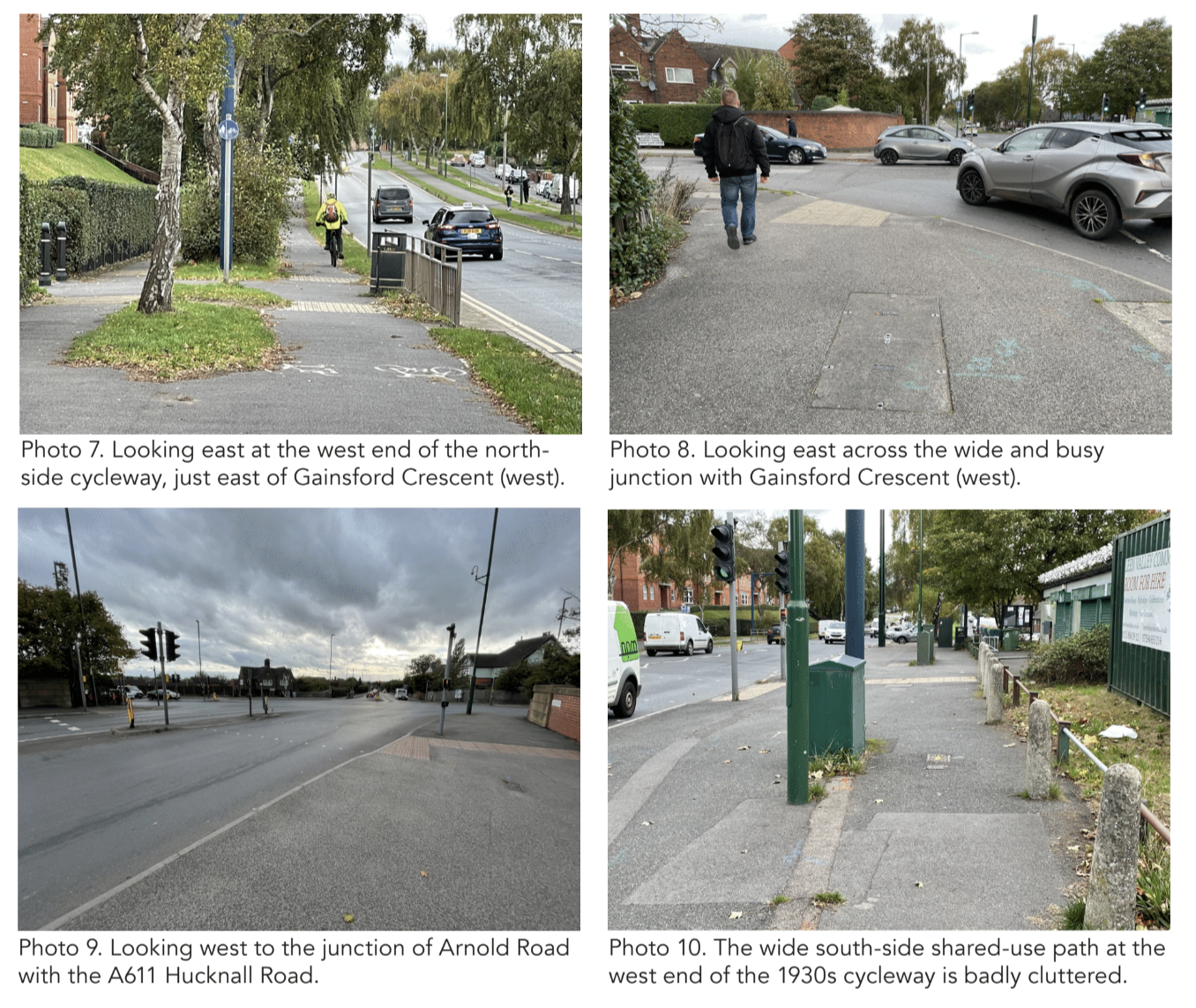
These proposals are for the designated north-south cycle route to avoid the constrained junction with Arnold Road by following the quiet Andover Road to the north, crossing Arnold Road at the existing Toucan by the Andover Road/Gainsford Crescent junction, and using the existing off-road cycle path to the south, which will be widened.
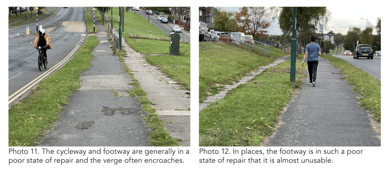
Concerning the side-street junctions, there is clearly space for even the widest to be improved so as to provide excellent walking and cycling priority.
While the 2018 Nottingham City Cycling Design Guide shows a template for suchimprovements that has much to recommend it, any future side street layouts should be in accordance with Figure 10.13 of LTN 1/20.
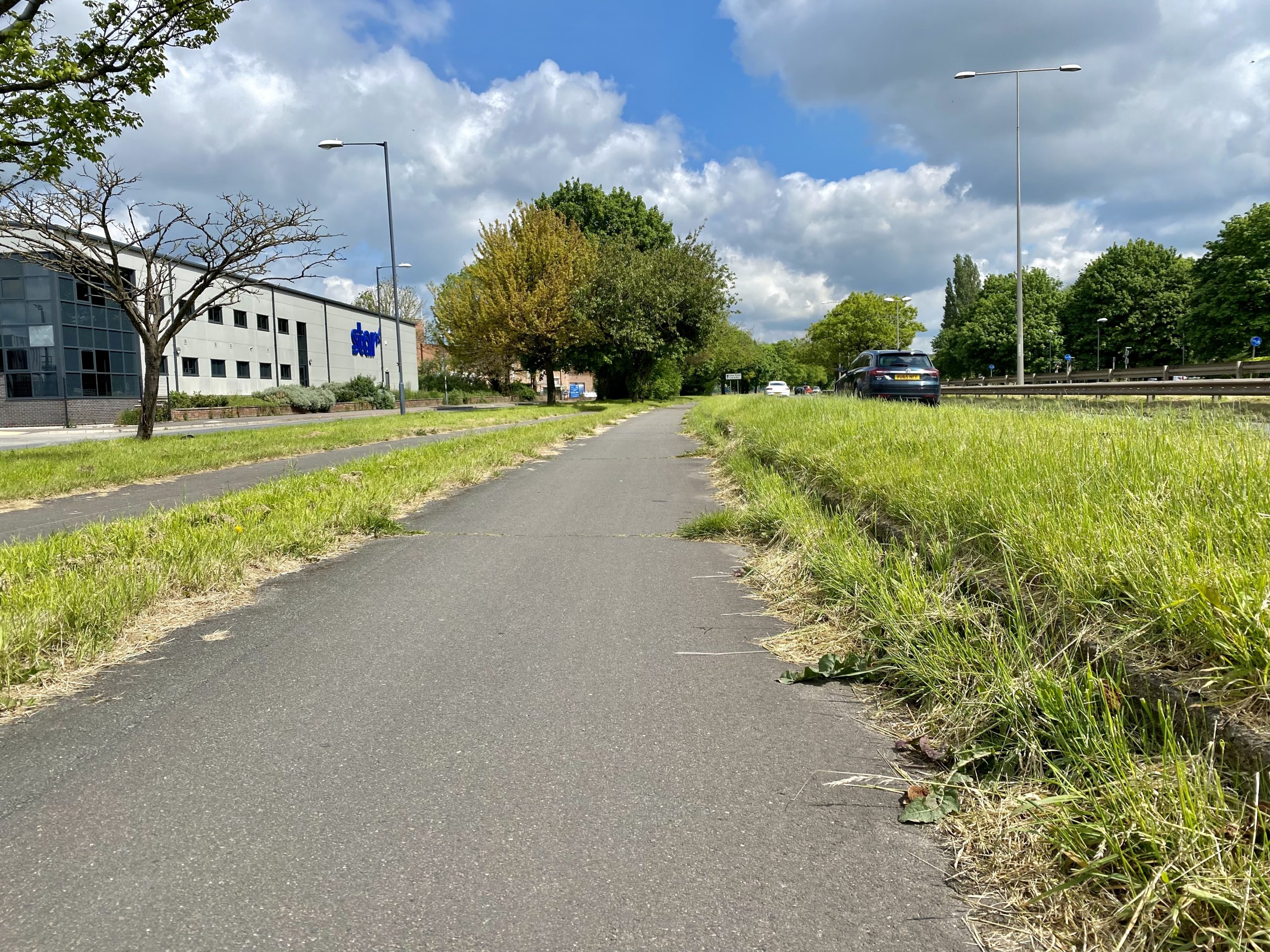
Raynesway, Derby
Location: A5111 Raynesway, Derby
Original Length: 2.45km
Authorities: Derby City Council and National Highways
Derby’s Raynesway — initially known as “Town Planning Road No. 4” — was opened by Alderman Edward Paulson, Mayor of Derby, on September 28th, 1938. It was named for Alderman W. R. Raynes, a long-time chairman of the Derby Estates and Development Committee. An official of the Derby Borough Surveyor’s Department told the Derby Daily Telegraph that the “cycle tracks each side of the road will extend the full length of the new section, a distance of 2,300 yards. They will be nine feet wide, and will have the same surface as the main road, which will be of concrete. Use of them will not be compulsory, but it is expected that they will be of value to cyclists travelling to the Spondon works of British Celanese, Ltd.”
Before building the road, Derby Town Council sent Mr. W. G. Penny, chief engineering assistant of the Highways Department, on a fact-finding trip to the Netherlands to “inspect cycle tracks constructed along main roads in that country.”
The Telegraph reported that the idea was that “much useful information may be obtained in this way.”
“Road authorities on the Continent,” pointed out a Council official, “are much more advanced in catering for cyclists than those in this country.”
The overall width of what became known as Raynesway was 120 ft, “comprising two carriageways each 22ft in width, two verges, each 7ft in width; two cycle tracks, each 9ft in width; two side verges, each 3ft in width; and two footways, each 8ft in width,” reported the Telegraph.
“The carriageways were constructed in concrete, and each was divided into two lanes which were easily distinguished by reason of a difference in the colour of the surface.
“Cycle tracks were constructed in red concrete, and, therefore easily distinguished.”
Much has changed since 1938, however, and indeed the subsequent physical alterations to the Raynesway are much more drastic than any affecting the other 1930s schemes in this report.
Raynesway runs broadly north-south and originally ran, more or less uninterrupted, from a roundabout with the Derby Road/Nottingham Road (what was then the A52) in the north, over what is now the Midland Mainline and also over the River Derwent, to a junction with Alvaston Street in the south.
The late 1970s, however, saw the construction of the Borrowash Bypass as the new alignment of the A52, which passes under Raynesway closely adjacent to the Midland Mainline. To connect Raynesway with the new A52, a new grade-separated junction (of a ‘modified trumpet’ layout) was created – named the Spondon Interchange. The interchange essentially destroyed a roughly 500m section of the original Raynesway, starting around 200m south of the Nottingham Road/ Derby Road roundabout. For that stretch, the 1930s cycleways and footways on both sides were replaced by a single shared-use path on the west side; and this also has an uncontrolled crossing of the Raynesway northbound to A52 westbound slip road.
South of the Spondon Interchange, the original 1930s facilities are still largely intact. However, those on the east side have no connection to or from the north.
On the west side, heading south, the original cycleway and footway continue in more or less their original form for around another 1km before reaching the bridge over the River Derwent. The North pier of this bridge sank about a metre into the riverbed in 1947, causing significant damage. While this was later repaired, and a major refurbishment was undertaken in 2009, the current layout of the footways and cycleways seems on likely to be exactly as originally.
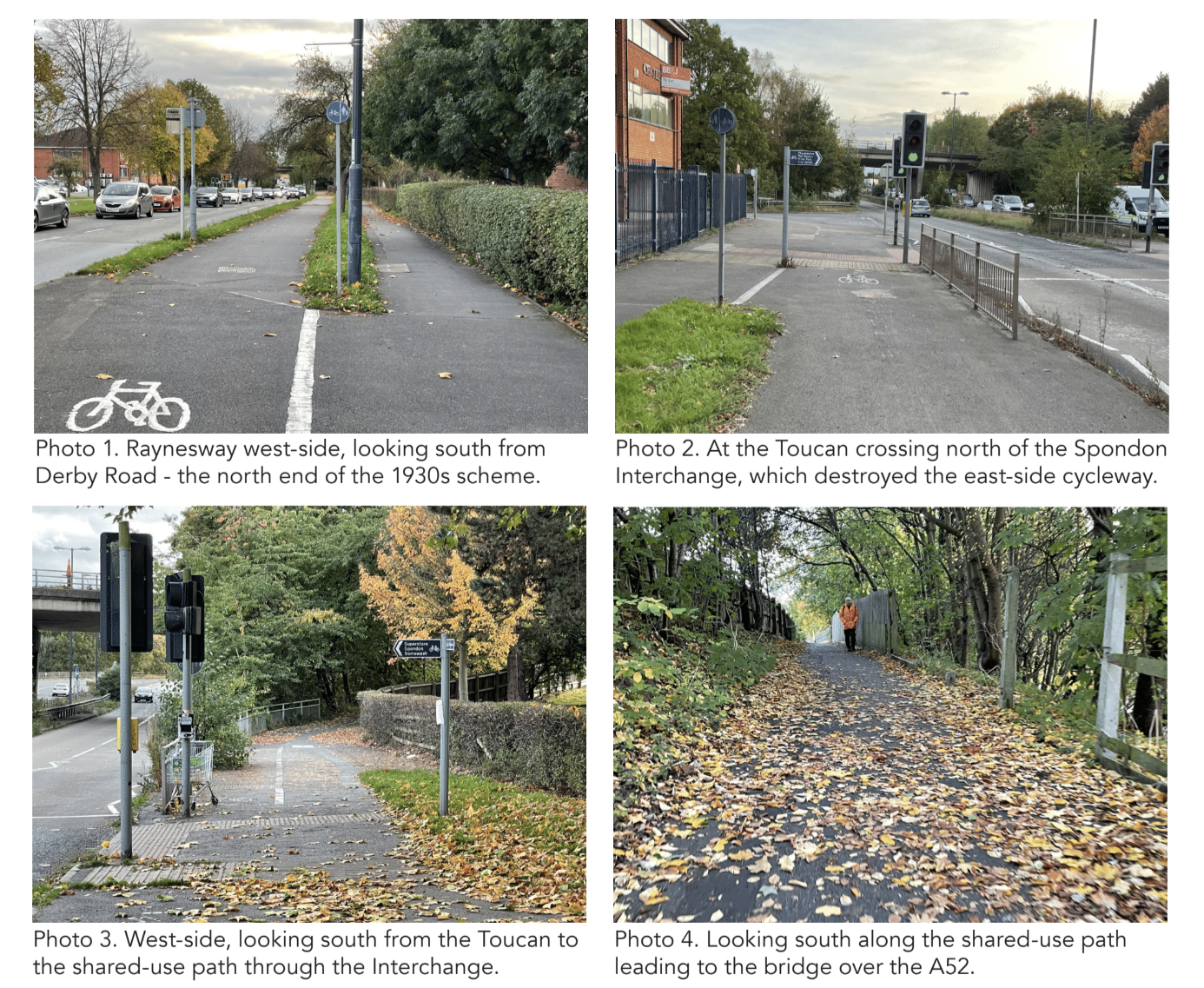
On each side, the combined width of footway and cycleway is around just 4m.
On the west side, the two elements are separated by a simple kerb step, while on the east, the arrangement is a single shared-use path.
South of the bridge, on the west side, little further trace of the 1930s cycleway and footway can be found. Following a junction with the ramp to/from National Cycle Route NCN6, which runs alongside the Derwent, there is a short stretch of shared use path before the route becomes part of Quinton Road – a comparatively new access road for adjacent industrial development.
Cycling must take place in the carriageway and there is a footway on the west side.
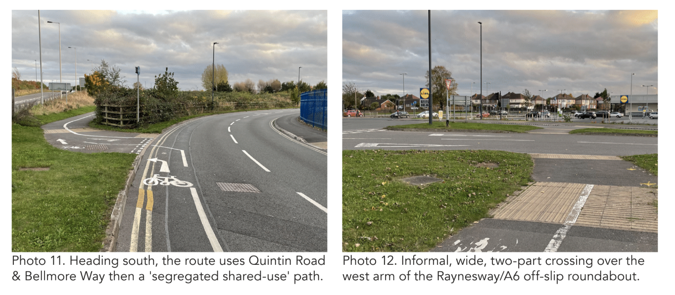
At the point where Quinton Road becomes Bellmore Way, it swings away to the west of Raynesway, though an off-road ‘segregated shared-use’ path has been created that keeps close to the A5111. Bellmore Way then swings back east again, to form the west arm of a large roundabout junction with Raynesway. This roundabout is part of the wider grade-separated Raynesway Park junction, between the A5111 and A6, constructed between 2009 and 2011.
Having crossed that wide west arm of the roundabout by way of an uncontrolled two-stage crossing via splitter island, the cycleway continues in the form of a ‘segregated shared-use’ path to a two-stage signalised crossing of the south arm (Raynesway), beyond which a ‘segregated shared-use’ path continues to the historic scheme end at Alvaston Street.
Arising from the A5111 Raynesway’s comparatively recent role as a strategic connection between the A6 and A52, the central part of the 1930s cycleway route is now the responsibility of National Highways, while the northern and southern sections are the responsibility of Derby City Council.
THE CHALLENGES
Following from the necessarily involved scheme description about, it can be seen that the principle challenges in connection with the contemporary role of the Raynesway cycleway arise less from the classic flaws of the 1930s layouts, or indeed from generally poor maintenance, but rather from the character of the changes imposed by the Spondon Interchange and Raynesway Park junction developments, as well as from modifications to the River Derwent bridge.
For the most part, these challenges relate to the fact that, in some sections, the historic separated footways and cycleways have been replaced by comparatively narrow shared-use paths. While these are not insuperable, there is one particular consequence of the major restructuring that will require a particular focus if the cycleway is once again to become a route suitable and safe for all. This is the informal, uncontrolled crossing of the A5111 northbound to A52 westbound slip road.
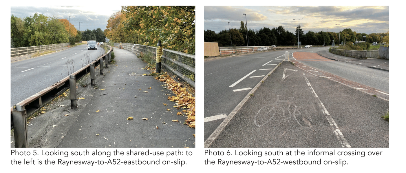
Despite red surfacing on the slip road carriageway, a diagram 950 sign with ‘Cyclists Crossing’ plate, a yellow-backed advance warning sign comprising both a diagram 950 and a diagram 512 left bend sign, and an additional advance warning diagram 512 sign with a white-on-red ‘Reduce Speed Now’ plate below, there is nothing effective to give any priority to people walking or cycling across. Consequently, people hoping to cross are required to wait and look for a gap that they judge to be sufficient. This arrangement, though understandable in the context of a 1970s approach to the design of strategic highways, is inadequate as a means of enabling ‘8 to 80’ walking and cycling.
Land constraints meant that some of the Spondon Interchange’s slip roads have smaller entry or exit radii than would have been considered desirable at the time. This is the case in relation to the A5111 northbound to A52 westbound on-slip, and there is therefore an advisory maximum speed limit of 20mph, in the context of a wider mandatory speed limit of 50mph.
At the large roundabout that forms part of the Raynesway Park junction, the crossing of the west (Bellmore Way) arm leaves much to be desired. The fact that it is uncontrolled and negotiated in two parts is not unacceptable in principle. However, it is undesirable and unnecessary that the approach from and exit to Bellmore Way, either side of the splitter island, are both two lanes wide, and that the geometry is such as to enable turning at inappropriate speeds, despite the speed limit being 30mph.
In the context of reinstating a high quality, connected walking and cycling route along Raynesway, the fact that the former east-side link was eliminated by the Spondon Interchange, means that the focus improvement must necessarily be on the west side.
However, the 1930s facilities still remain – in generally good condition – alongside the East Service Road, and there are numerous employment opportunities adjacent.
The obvious challenge to enabling the use of the east-side footway and cycleway is the lack of a crossing over Raynesway between the Spondon Interchange and the Derwent Bridge. There is a signalised crossing on the north side of Spondon Interchange, and although this is not part of the National Highways network Raynesway in the north is subject to the same 50mph speed limit as it is on the south side.
Other challenges along the west-side route are more familiar. For example, the three junctions with the West Service Road, between the Spondon Interchange and the Derwent bridge, are all excessively wide, and give no priority to walking or cycling across. Indeed, there are some ‘Cyclists Dismount’ signs. The fact that the main carriageway speed limit is 50 mph adds to the challenge of finding the best design solution.
THE OPPORTUNITY
Put simply, the opportunity is to build on the 1930s legacy to create a high quality cycling and walking route between communities to the north and south, overcoming several major severance features (including the A52, Midland Mainline and River Derwent) and enabling access to a range of employment opportunities.
At 2.5km, the distance between Derby Road and Alvaston Street could be cycled in just 10 minutes at a modest pace, yet for many it will currently seem as though motorised transport is the only option.
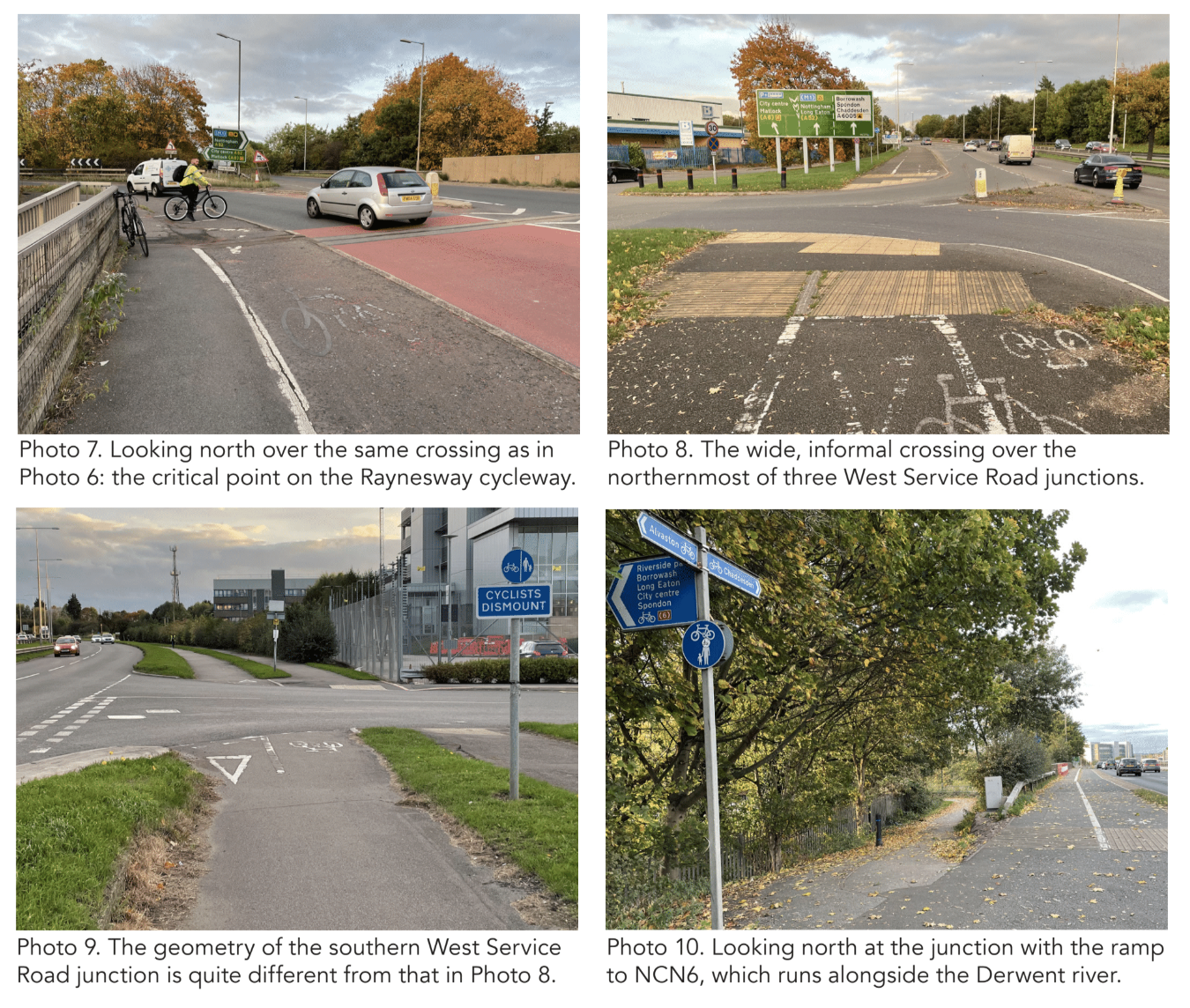
For the reasons stated above, the focus of improvement works should, in the first place, be on the west side. Where the original footways and cycleways remain – as they do for long sections – these can readily be improved through resurfacing and modest widening. A 3m-wide bi-directional cycleway, alongside a 2m footway, with grass verges either side of the cycleway, would represent very good provision.
As for the comparatively narrow shared-use path sections, the low footfall, the fact that the width is generally between 3m and 4m, and the likely future cycle flows in such a context, mean that if the full width of the paths is maintained (i.e. all encroachment is cut back), if they are well surfaced and lit, and if they are appropriately protected when immediately adjacent to the main carriageway then they can provide a good level of service for all users.
At the north end of the scheme, there is enough space to create a much better transition between the walking and cycling facilities on both sides of Raynesway and the Derby Road/Nottingham Road roundabout.
There is also the opportunity to create a better connection with the shared-use path on the south side of Derby Road, leading to the key local destination of the Asda superstore.
On the northern section of Raynesway itself, the separate footway and cycleway on the east side can be reinstated, where they have been lost, through the removal of the bus lay-by and the reintroduction of the separating verge. Consideration can also be given to improving the quality of the cycling and walking link along Aspen Drive, just south of the Toucan crossing, which also leads towards the superstore.
As has been mentioned, the biggest single challenge facing the creation of an attractive, cohesive route is the improvement of the crossing of the A5111 northbound to A52 westbound slip road. However, the fact that there is an advisory 20mph speed limit on the slip road points to the potential benefits of measures likely to reduce the speed of vehicles making that turn, and the introduction of a signalised crossing could be part of a package. The best location for such a crossing might be somewhat further south of where the existing informal facility is; and it will also be appropriate to explore the modification of the highway layout leading up to the crossing point, from as far back as the northernmost of the West Service Road junctions with Raynesway.
Any modifications should also seek to increase the width of the ‘segregated shared-use’ path south of the crossing, and increase the degree of separation from the vehicular carriageway.
Each of the West Service Road junctions can be improved, and there is space within the short linking roads to enable the walking and cycling crossings to be set back so that vehicles leaving Raynesway can wait clear of the main carriageway to let people on foot or cycles cross.
At the very least, even if a high degree of priority for people walking or cycling across cannot be achieved – because of the speeds of vehicles leaving a main carriageway with a 50mph limit, there is scope to reduce turn radii, and hence vehicle speeds, appreciably.
A detailed review of the collision record and any other previous issues recorded concerning the layout of the A5111 and junctions in this area should inform any proposals for change. (Crashmap indicates that, on the west side of Raynesway between the south side of the Spondon Interchange and the southern junction with the West Service Road, there were seven collisions in the five years 2017 to 2021 resulting in 13 injuries, four of which were serious.)
Further south, opportunities include improving the transition between cycling in the Bellmore Way carriageway (in both directions) and the off-road ‘segregated shared-use’ path that takes a more direct line to the Bellmore Way/ Raynesway roundabout. At the roundabout itself, all arms of which are subject to a 30mph limit, there is – at the very least – a clear opportunity to substantially modify the west (Bellmore Way) arm, and the quality of the walking and cycling crossing over it.
While a comprehensive remodelling of the roundabout could perhaps be considered, the Bellmore Way arms stands out as being ‘over-designed’.
The entry and exit could both be a single lane, and the turn radii could be significantly reduced. Under such circumstances, an uncontrolled crossing would be acceptable, and the splitter island could be modified to provide both a wider and a deeper crossing/waiting area.
Narrowing the Bellmore Way entry to a single lane would also enable widening of the ‘segregated shared-use’ path on the south side and appreciably reduce the angle between that path and the direction of crossing (which is unnecessarily close to a right angle as things stand).
Modifying the entry radius could also provide a more generous waiting area on the north side of the signalised two-stage crossing over Raynesway towards Alvaston Street (at the north east corner of the Lidl car park).
In addition to better connecting the Raynesway cycleway and the path on the south side of Derby Road, there’s a need to improve the Derby Road path itself, to create a much better route to/from Asda.
As things stands, the shared use facility between Raynesway and Aspen Drive is little or no wider than 2m and has obstacles in it.
There is no walking or cycling priority over the excessively wide mouth of the Aspen Drive junction; while east of this there is almost 6m of public highway space on the south side of Derby Road, but the majority is given over to a grass verge. This should be narrowed to create a 4m shared use path.
At the south end of the 1930s scheme there’s the opportunity to create a high quality walking and cycling connection with the Alvaston local centre, a few hundred metres along the A5111. The space is there.
Between the Raynesway Park and A6/London Road roundabouts, it’s in the form of wide service roads on both sidea.
On Shardlow Road, there’s at least 3m in the form of a third northbound lane between Blue Peter Island and London Road that could be repurposed.
Melton Road, Thurmaston, Leicester + Leicestershire
Location: A607 Melton Road, Thurmaston, Leicester
Original Length: 1.4km
Authorities: Leicester City Council and Leicestershire County Council
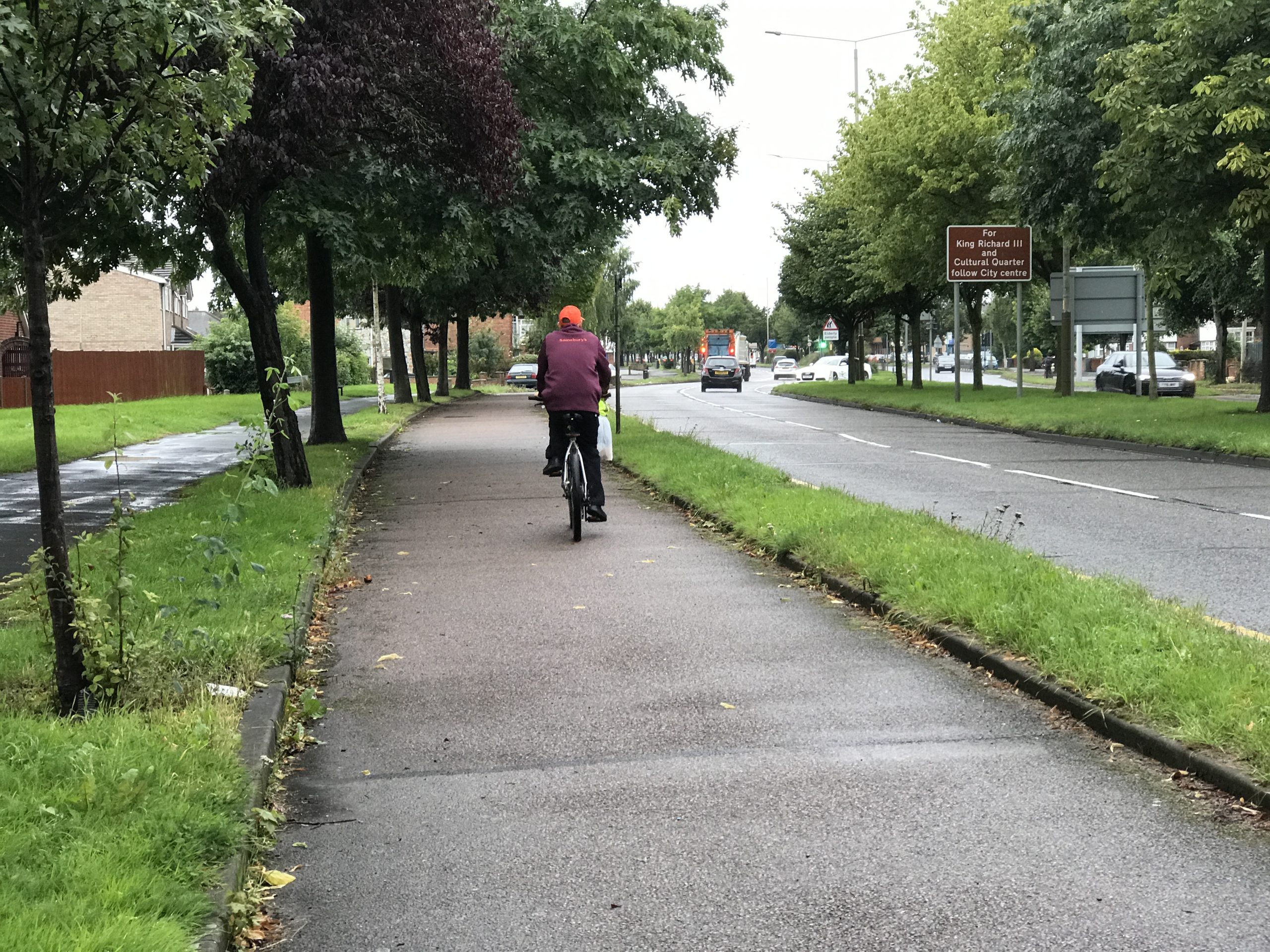
What is now the A607 Melton Road has a long history. Its general straightness is a clue to the fact it is built on the same alignment as the Roman Fosse Way and, in the 18th Century, it was improved as part of the Melton Mowbray turnpike.
An announcement that cycle tracks would be constructed as part of the scheme to create a dual carriageway on part of Melton Road was made in 1936.
“Another scheme that is to be carried out is the widening of Melton-road from the tram terminus to the city boundary,” reported the Nottingham Journal in that year, adding that the road “will include a special track for cyclists – the first in the Midlands.
Subsequently, in 1937, the Leicester Evening Mail reported that “The Surveyor’s Department of Leicestershire County Council is about to begin a survey of the land and the preparation of plans for the scheme.”
The newspaper added that “It was considered by the parish council that the construction of the road was an urgent matter.”
Based on this information, it is probable that the cycle tracks were installed some time between 1937 and 1939.
Evidence on the ground and from historic mapping suggests strongly that the cycleways originally extended from the junction with Lanesborough Road in the south to just south of the junction with Manor Road in the north. Lanesborough Road wasn’t built until at least 20 years later, and the junction in question was originally with Wavertree Drive.
The northern end of the scheme is at the boundary between Leicester City and Leicestershire County. The cycleways were constructed on both sides of the road. However, it would appear from what’s on the ground today that, for large sections on the west side (and much shorter sections on the east), the form of provision for cycling was not a distinct cycle track but rather a lightly-trafficked service road.
Although this is typical of many 1930s-era cycleways, it is unclear whether these service roads were an original feature or a later modification.
The major physical interventions since the construction of the 1930s cycleways have been the creation of a major signalised junction with the A563 Leicester Ring Road (Watermead Way and Troon Way at this point). A second new signalised junction on the Melton Road has also been introduced, a short way north of the A563, to provide access to the Sainsbury’s superstore on the east side.
As a consequence of both these interventions, the original east-side cycleways at and between the junctions have been destroyed.
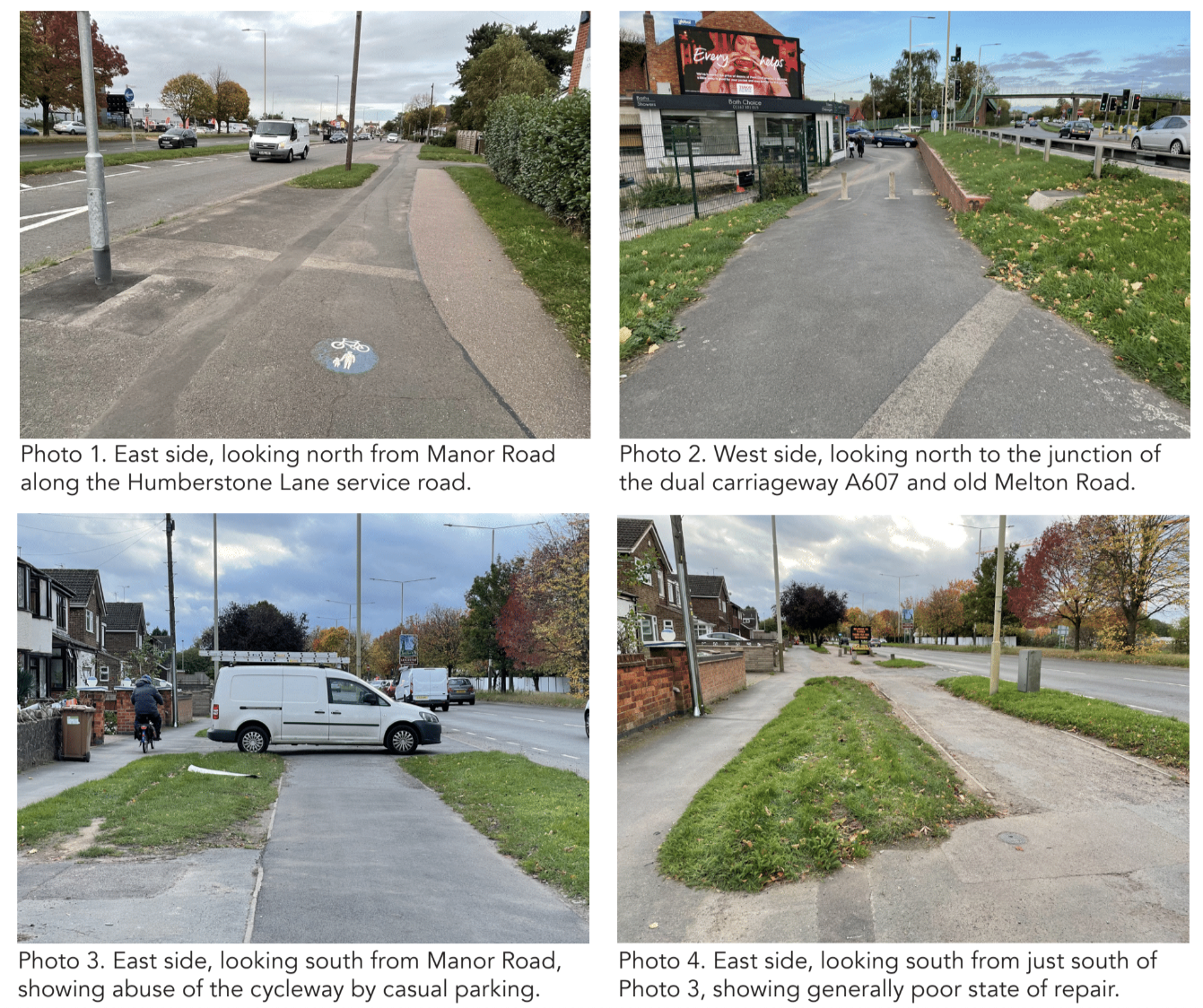
As stated, there are several sections of service road on the west side. The fact that vehicles are permitted on these sections, allied to the industrial character of much of the adjacent land use, means that the cycleway is much less well-observed than its counterpart on the east side.
Levels of cycling are likely also suppressed by the fact that there is no signalised crossing over the west arm of the A563.
South of the southern end of the 1930s scheme, Melton Road is laid out as a single carriageway that varies in width from around 10-12m. The street has a mixture of residential and local commercial frontage, with much of the kerbside space used for parking.
Melton Road is an important bus corridor, and a southbound buslane runs from the A563 to around 200m south of the end of the 1930s scheme.
Rushey Fields Recreation Ground is just south of the scheme on the east side of Melton Road, and a shared usepath runs through it.
As is the case with many 1930s cycleways, the northern end is particularly abrupt. The quality of cycling links between it and Humberstone Lane/ Thurmaston local centre (east side) and the old single carriageway section of the Melton Road (west side) is generally poor.
National Cycle Route NCN6 runs parallel to Melton Road, a few hundred metres to the west. A direct, shared use path link between the twolink was recently constructed, joining Melton Road at almost exactly the northernmost extent of the 1930s scheme.
THE CHALLENGES
The 1930s cycleways on Melton Road suffer from three principal problems that are generic for all the cycleways built in that era: they give up at junctions – even those with minor side streets; they do not themselves connect important origins/destinations; and they terminate abruptly without connecting to a wider cycling network of similar standard.
Another important issue in relation to the Melton Road cycleways is the physical condition of the surface. This seems largely to be the original concrete, which has endured remarkably well.
However, along with general wear and tear of the comparatively rough original surface, there are numerous ruts, cracks and patches related to localised failures, at joins between sections of concrete and as a result of tree root damage.
There is also the matter that the cycleway on the west side is considerably less attractive for cycling than that on the east. While the east-side cycleway is largely continuous – whether in its original or a modified form – the cycling provision on the west side is much less so.
There are numerous sections that are service roads, where parked vehicles often obstruct passage. The section alongside the industrial area north of Lanesborough Road has been damaged by previous interventions. What was the footway there is now largely used for parking (and a food wagon!) so that even where the 1930s cycleway is in good condition it is largely used as a footway. And there is no crossing over the west arm of the A563 Ring Road junction.
Casual parking in the cycleway is another challenge – and again one that’s common to a number of other 1930s cycleways.
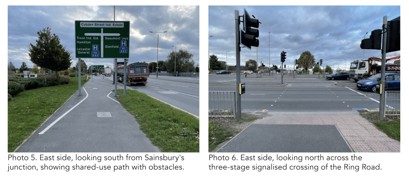
On the east side, the historic cycleway has been lost between just north of the Sainsbury’s junction and the southern edge of the open space on the south side of the Ring Road junction, a distance of almost 300m. What’s now in its place is a shared-use path of varying dimensions, the widest section of which (between the Sainsbury’s and A563 junctions) is compromised by the fact of localised narrowings to accommodate the poles that support three separate, large directional signs on approach to the Ring Road.
There is then also the matter of the cycling facilities at those signalised junctions themselves. The Sainsbury’s junction provides a two-stage crossing that is shared with people on foot, while the A563 crossing is in three stages each of which is also shared with people on foot. These arrangements accord walking and cycling a very low priority, and although this is perhaps understandable in the context of the A563 junction, it is less so at the Sainsbury’s junction.
In addition to the general inconvenience and delays created by the multi-stage arrangements, the dimensions of the layouts make movement on foot or cycle far less comfortable than needs to be the case.
Even if the basic signalling arrangements are unchanged, appreciable improvements could be made by enlarging islands and widening crossing points.
South of the A563, the east-side cycleway and footway are largely intact, if in poor repair, and the major issue is that of the layout of side street junctions.
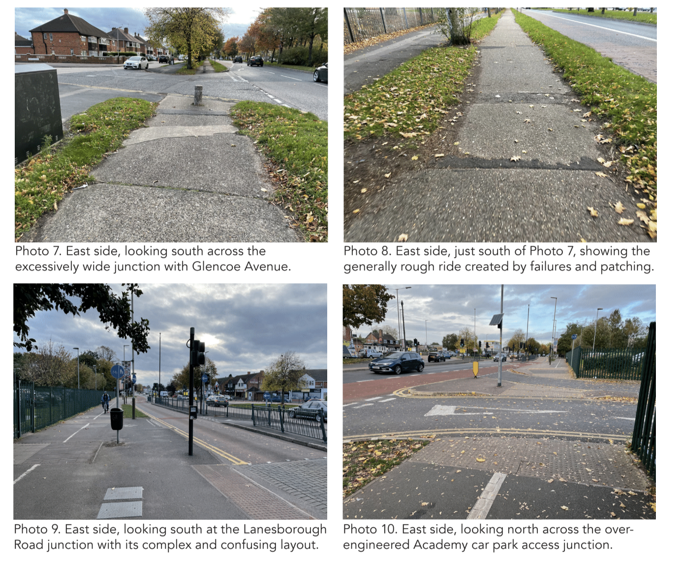
At the southern end of the scheme, comparatively recent modifications to the Lanesborough Road roundabout – to provide good bus priority on what is an important radial corridor – have impinged on the original layout so that it becomes a much narrower ‘segregated shared-use’ path just where it often comes under the greatest user pressure: outside the main gates of the Rushey Mead Academy.
At its northern end, the 1930s scheme simply stopped at the City/County boundary, failing to connect with the Humberstone Lane local centre, a little further north. At its southern end, the scheme similarly stopped dead at what was then the junction with Wavertree Drive/Lanesborough Road. People cycling had simply to negotiate the rest of Melton Road further south as best they could.
THE OPPORTUNITY
The 1930s scheme presents the clear opportunity to create a 1.7km long, high quality walking and cycling route on the east side of Melton Road between Humberstone Lane in the north and Rushey Fields in the south. The separate footway will be 2m wide, with the cycleway being 3m wide and used for bi-directional cycling.
There will be several Toucan crossing points enabling access to and from the west, with the historic features also improved on the west side, north of Alderton Close, to connect with the northern part of Melton Road and the shared-use path linking to NCN6 and Watermead Country Park.
To achieve this will require the following generic improvements.
- Repairs to and resurfacing of the 1930s footways, cycleways and verges, with modest widening of the cycleways.
- Remodelling of side street/access junctions to provide walking and cycling priority across, in keeping with LTN 1/20 Figure 10.13. (These include the junctions at Pinfold Road, Manor Road, Jacklin Drive, Hardy’s Avenue, Glencoe Avenue, and the Rushey Mead Academy car park access.)
- Modification of bus stop layouts to a consistent design, using the verges for locating shelters.
- Removal of concrete bollards, and/or replacement with more forgiving alternatives; and general de-cluttering (e.g. removal of unnecessary ‘guard’-rail panels).
- Widening of the Toucan facilities near Pinfold Road, Alderton Close, Hardy’s Avenue and Uxbridge Road.
In addition, the following specific interventions are need along the length of the original scheme:
- Modifications to the signalised junction with the Sainsbury’s access, to provide greater directness, comfort and convenience for people walking and cycling across; and a better transition for people cycling to and from the superstore itself.
- Improvements to the east-side shared-use path between the Sainsbury’s access and the A563, including widening or reinstatement of a separate footway and cycleway, and the relocation of sign poles.
- Modifications to the signalised crossing facilities on the east arm of the A563 junction. As a minimum, crossing points and facilities should be more wide/deep and more direct. More substantial remodelling should be considered, including removing the dedicated A607 southbound to A563 eastbound lane to make the walking/cycling crossing possible in two stages, not three.
- Modification of the existing layout at the Lanesborough Road roundabout to widen the walking and cycling facilities and enable a better transition with cycling on Lanesborough Road itself, while maintaining good southbound bus priority.
To add value to the 1930s facilities, better connections are needed at both the north and south ends of the original scheme. To the north, there is clear scope for substantially improving the connection from Manor Road to the Thurmaston local centre and Melton Road/ Humberstone Lane junction, including the signalised crossing of the Humberstone Lane arm. This crossing connects with the quiet route along Wayside Drive which, in turn, connects with the 3m shared-use path on the east side of the A607 Newark Road.
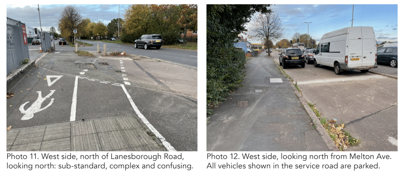
There is more than adequate width in the section of Humberstone Lane that runs parallel to Melton Road north of Manor Road to provide separate, wide footway and cycleway facilities to replace the existing narrow shared-use path.
To the south, the original scheme can readily be extended a short distance on the east side to form a better junction with the shared-use path through Rushey Fields.
Just south of that junction, there is sufficient space to create a new Toucan crossing. This is needed to enable a safe transition between the east-side bi-directional cycleway to the north and in-carriageway cycling, in both directions, on Melton Road to the south.
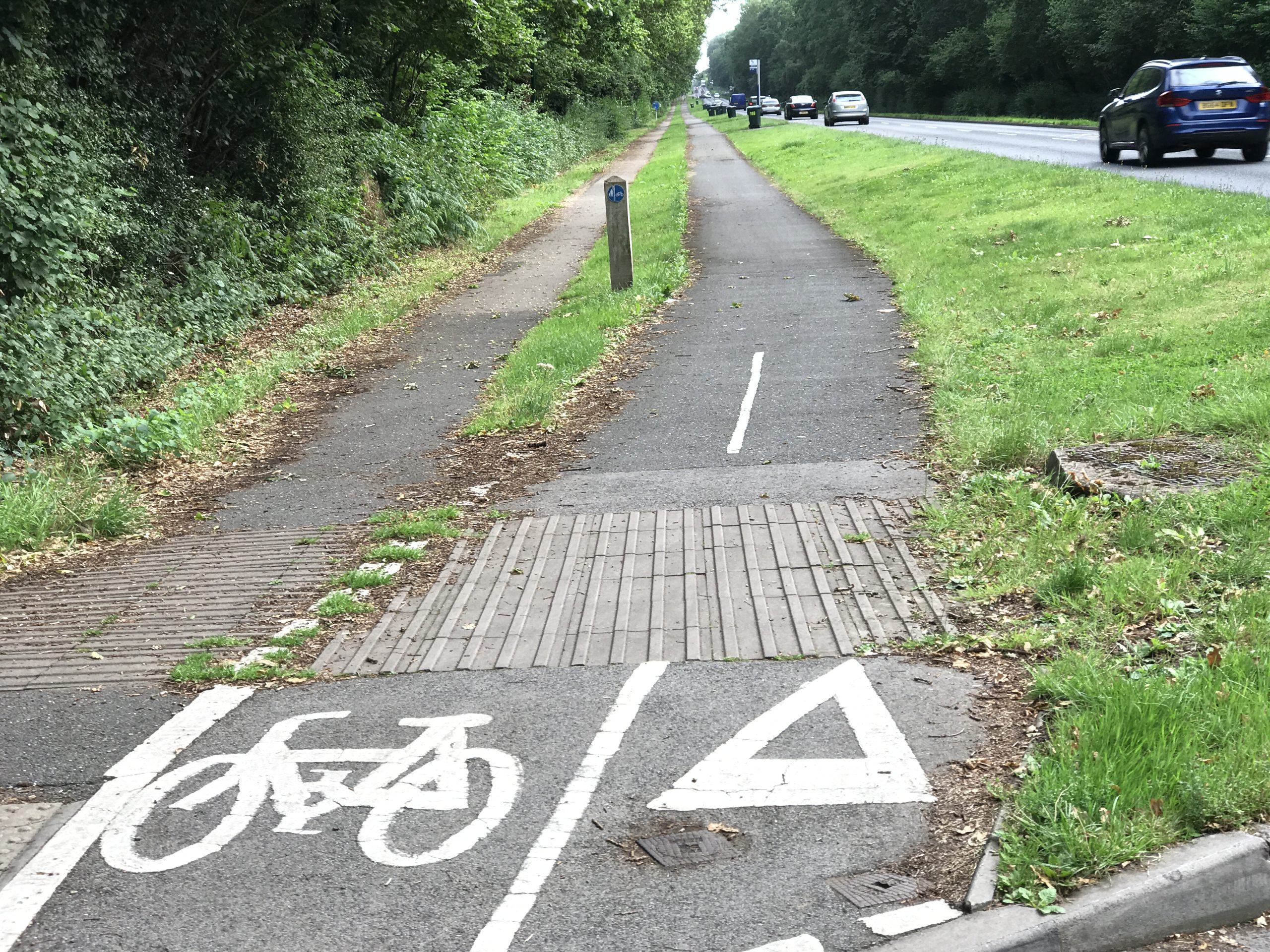
Kenilworth Road, Coventry + Warwickshire
Location: A429 Kenilworth Road, Coventry
Original Length: 2.7km
Authorities: Coventry City Council and Warwickshire County Council
The Kenilworth Road cycleways – which would originally have run on both sides of the single carriageway road – were constructed between 1938 and 1939.
There had previously been stiff opposition to the tracks from both locals and cycling organisations. The first plans for cycleways on the road were lodged with the Ministry of Transport in 1934.
“Coventry City Council decided this morning to defer the question of constructing a cyclists’ track along the grass verge of Kenilworth Road from the Grove to Gibbet Hill,” stated a 1934 newspaper report.
“This proposal, sponsored by the Ministry of Transport and estimated to cost £4,400, would have involved a nett expenditure by the Corporation of £1,760, the remainder being met by the Ministry,” the report continued.
“The main question in the minds of members was their determination to safeguard the amenities of Kenilworth Road from anything which savoured of spoliation.”
Alderman Wyley said the Kenilworth Road was “one of the most beautiful spots in England, and anything that would detract from the beauty of that road would be deplored, not only by the citizens of Coventry, but by many people outside.”
He feared that the proposed 9ft cycleways would “become little more than a cyclists’ racing track.”
The Council voted against the proposal at that time, but reintroduced the scheme two years later.
Again, it was voted down.
“The [Coventry] Corporation have set a good example in their care for the beautiful Kenilworth Road,” reported the Coventry Herald in 1936, “and have resisted the proposal to detract from its amenities by constructing cycle tracks along it.”
Opposition to the cycleways was finally overturned two years later when “Kenilworth Urban District Council … made a declaration in favour of tracks for the exclusive use of cyclists,” reported the Leamington Spa Courier in 1938.
The original scheme ran between the junction with the Kenpas Highway (now the A45) in the north and the boundary between the City and County boundaries to the south.
In some respects it is surprising that the cycleways and footways were introduced despite the plain opposition of some, because it is not that they were originally of any great practical utility.
Although there were some homes to east and west, these were (and remain) large houses, set well back, and relatively small in number. The southern end of the route was somewhat arbitrary and, although there were also cycleways on the Kenpas Highway, a direct connection between the two was never made.
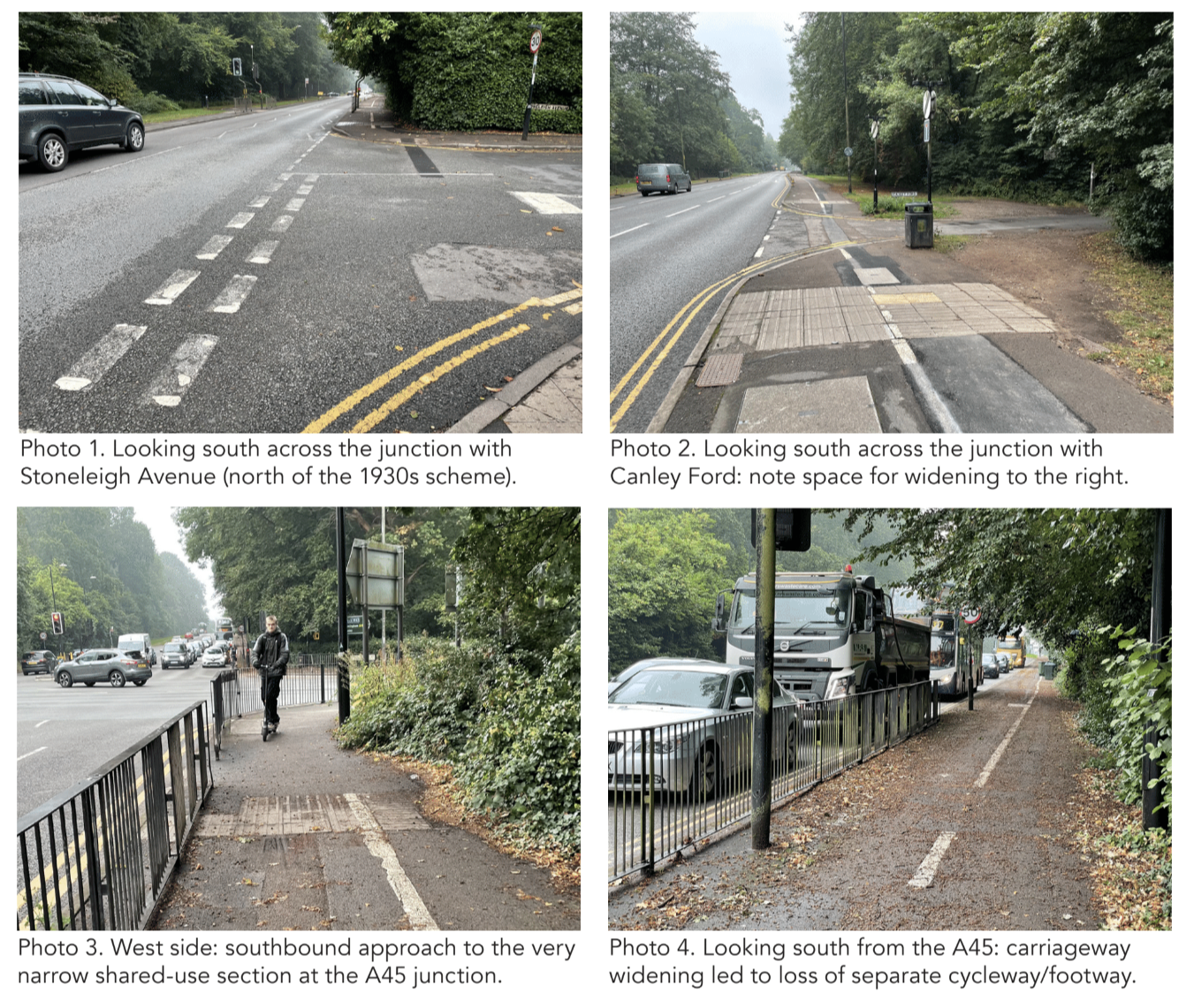
There was no onward link created or, it seems, planned with Coventry City Centre. On the east side, the original cycleway and footway have essentially been lost over time.
A narrow footpath remains between Kenpas Highway and Stoneleigh Road, but south of Stoneleigh Road there is now nothing but a wide grass verge.
On the west side, the separate footway and cycleway are still both visible and in use, and the grass verges between the two, and between the cycleway and single carriageway road remain present.
However, it would appear that, over time, both the footway and cycleway have become narrower than the original 6ft and 9ft – with the footway generally about 1.5m wide and the cycleway often little or no wider than 2m.
At the City/County boundary, the separate footway and cycleway merge into a single shared-use path that continues south, through what is currently a major HS2 work site, to reach the village of Crackley, where the designated route stops.
Around 350m south of that point,where Kenilworth Road has become Coventry Road, there is a junction with Kenilworth Greenway (National Cycle Routes NCN52and NCN523) which runs along an old railway corridor.
THE CHALLENGES
The state of repair of the west-side footway and cycleway is much better than is common elsewhere, but this seems to have been achieved at the expense of appreciable narrowing over time. As regards the main features themselves, therefore, the principal challenge is to widen both. In particular, the cycleway needs to become more suitable for bi-directional cycling. It is currently laid out and used as such, but around 2m is insufficient width for this to happen comfortably or for increased cycling flows to be encouraged.
For around the first 150m south of the A45 junction, the quality of the walking and cycling facilities has been badly affected by the widening of the A429 carriageway to provide a third northbound approach lane to the A45. Although the ‘segregated shared-use’ path is reasonably wide (around 4m), it is impinged upon by encroaching shrubs, fixed obstacles and numerous wheelie bins.
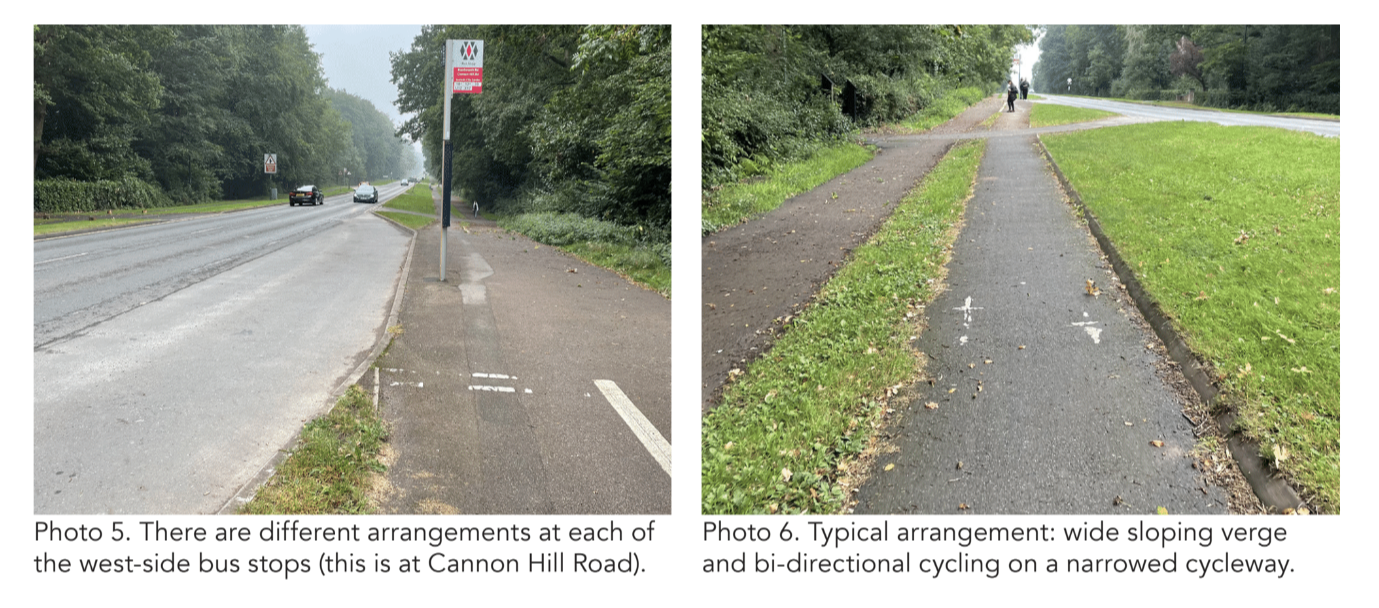
There is also no separation from the main carriageway. The scheme also suffers from the classic 1930s flaw of providing very poor priority at side street junctions. This issue is somewhat exacerbated along the Kenilworth Road by the presence of numerous access to the private driveways of the adjacent homes.
The almost complete loss of the original features on the east side of Kenilworth Road is not a major problem, bearing in mind the fact there are very few properties on that side and also that the main road is a single carriageway and therefore comparatively easy to cross.
The principal challenges relate to the need to connect the cycleways much better to both the north and south. In this regard, the junction with the A45 is by far the most problematic issue, with both walking and cycling currently squeezed together on narrow shared-use paths both sides of the A45 west arm, and with the island on the staggered signalised crossing being similarly narrow.
Comfort and convenience for walking and cycling are both badly compromised here.
North of the A45, on the west side, while there appears to be sufficient public highway space to create walking and cycling facilities of a good standard, this space is not fully utilised and it is also compromised by both fixed and floating clutter.
South of the historic scheme, the shared-use path is below 3m wide in some places, and there is no separation from the main carriageway.
A new, wide junction has recently been formed to provide access to the HS2 work site, and this will need to be substantially narrowed once works are complete.
Further south, the biggest challenge is the complete absence of any cycling facilities through Crackley to connect with the Kenilworth Greenway. As things stand, people on cycles are simply and unceremoniously ushered back into the main carriageway.
THE OPPORTUNITY
While the logic for the original scheme seems somewhat questionable, in terms of its practical purpose, the fact is that it now presents an excellent opportunity to create a high standard walking and cycling link between Crackley/ Kenilworth and Coventry.
This isn’t just about connecting communities that are potentially only a 20-25 minute safe and convenient cycle ride apart. It is also about improving the active travel infrastructure for people going to and from the main University of Warwick campus, only about 1km to the west; while the cycleway could also be of real value to the people who will soon live within the new developments proposed along Stoneleigh Road, less than 1km to the east.
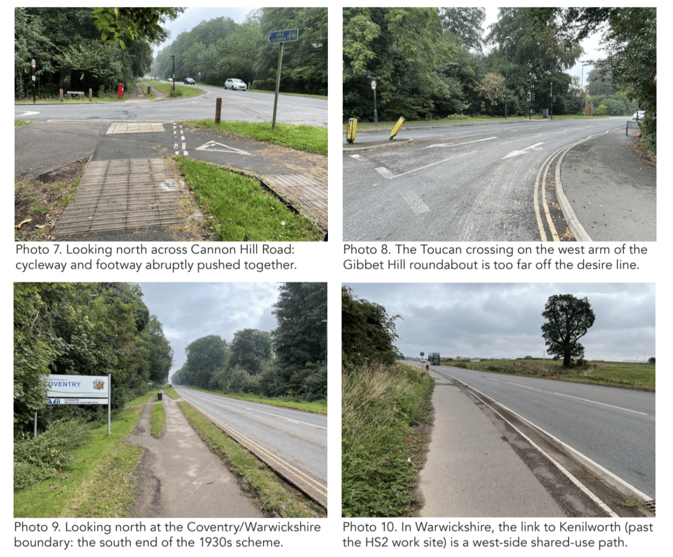
At the very least, the improvement of the historic footways and cycleways would be of appreciable value to the many people who already use them to travel to and from the University, including those who use the bus stops along Kenilworth Road.
At a more strategic level, the Kenilworth Road cycleways have the clear potential to create a high quality NCN52 connection with Coventry City Centre.
There is currently a gap in NCN52, and while a link through the main University campus makes excellent sense, this currently does not reach through to Coventry.
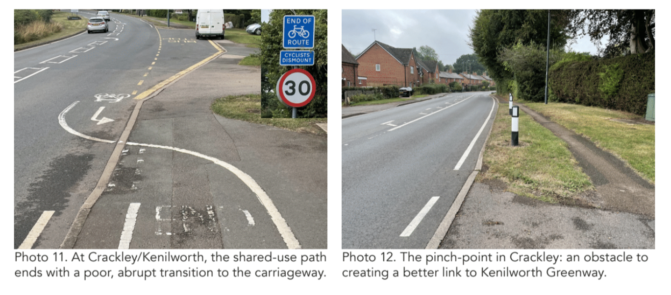
To make the most of these opportunities, the following improvements to the stretch of Kenilworth Road covered by the original scheme are necessary, and entirely achievable:
- General widening of the west-side footway to 2m and cycleway to 3m, using space reallocated from the verges.
- Immediately south of the A45, the 4m-wide (approx) ‘segregated shared-use’ should be improved as far as possible. It should be cleared of clutter and the adjacent vegetation cut back to the maximum possible extent.
- Remodelling of side street junctions to provide walking and cycling priority across, in keeping with LTN 1/20 Figure 10.13. (These are the junctions at Cannon Hill Road, Abberton Way and Cryfield Grange Road.)
- Modest improvements to some of the private driveway accesses to enhance walking and cycling priority across.
- Modification of bus stop layouts to a consistent design, using the verges for locating shelters.
- Remodelling of the Gibbett Hill Road (west) arm of the Kenilworth Road/Stoneleigh Road roundabout. This is necessary to bring the Toucan crossing appreciably closer to the north-south desire line along Kenilworth Road, as well as to provide a considerably wider shared use path on both sides. Narrowing of the eastbound approach to the roundabout from two lanes to one should be considered.
The key benefits of intervention along Kenilworth Road arise from what can be done north and south of the original scheme. The following proposals will be more or less difficult to achieve, but each is necessary and all are possible. They are listed in order from north to south.
- The junction of Kenilworth Road with Stoneleigh Avenue (NCN52) can be considered the northernmost part of the extension, and this should be remodelled to enable safer and more convenient cycling transition between the side street and the shared-use path on the west side, which connects with the Toucan crossing.
- South of the Toucan, there is plentiful verge space within the public highway to create a separate 2m footway and 3m bi-directional cycleway, with separation from the carriageway.
- Greater priority across the Canley Ford side junction should be provided, in accordance with LTN 1/20 Figure 10.13.
- South of the access to no.38 Kenilworth Road, maximise the width of the ‘segregated shared-use’ path as far as possible, cutting back all encroaching vegetation and modifying the bus stop layout. Remove the half-depth bus lay-by.
- At the A45 junction, more land will be needed on both the northwest and southwest corners in order to widen the shared-use paths and crossing point to an acceptable standard. It is understood that the land to the southwest is part of the public highway, whereas the land to the northwest is in private ownership. It is, however, currently a vacant site and negotiations with the owner for the purchase of a modest strip of land should be explored.
- In the longer term, lane reductions on the A45 and – perhaps especially – the A429 should be explored in the light of the success of wider plans to reduce overall traffic levels.
- South of the County boundary, the shared-use path on the west side of Kenilworth Road should be widened to a minimum of 3m.
- A 3m-wide path is the proposal associated with the HS2 works. When works are complete, the new junction on the west side should be laid out to ensure good priority and safety for walking and cycling across.
- South of Crackley Brook and through to the junction with Kenilworth Greenway, the shared-use path on the west side should be extended and maintained at 3m wide if at all possible. This is the current proposal by Warwickshire County Council,although the 3m width will be challenging to achieve in one section.
Marston Road, Oxford
Location: B4150 Marston Road, Oxford
Original Length: 730m
Authority: Oxfordshire County Council
Very little is known about the history of the 1930s scheme on part of Marston Road. Period mapping shows the existence of cycleways in that decade, as does the 1945 aerial photography made available by Google. As yet, however, no documentary evidence for scheme has been found.
At little more than 700m long, it’s one of the shortest schemes to have been discovered and the shortest covered by this report.
The southern end is at the junction with Edgeway Road and its northern end is at the junction with Old Marston Road.
Between these two junctions, both of both are on the west side, Marston Road is a single carriageway around 9m wide (likely 30ft at the time of construction). It carries one running lane in each direction, with the remaining space used either for kerbside parking on one side or for a central island/right-turn pocket, with hatching.
To each side of the carriageway is a strip around 7.3m (24ft wide) which is divided into grass verge, a cycleway, a second grass verge and a footway. The latter finishes against the property line.
Both the footway and cycleway seem to be – and may originally have been – the same width: 2.4m (8ft).
With Marston Road being comparatively narrow and easy to cross, and with it having always been a street of residential character with relatively low traffic speeds, a cycleway width below the common 1930s standard of 9ft (2.74m) was likely not a particular issue, as they would mostly have been used for with-flow cycling, not as bi-directional facilities.
Immediately south of the scheme, Marston Road has an approximately 10m-wide carriageway with footways of around 2.5m on each side.
Further south still, the layout varies quite considerably, while remaining essentially a single carriageway with footways on each side.
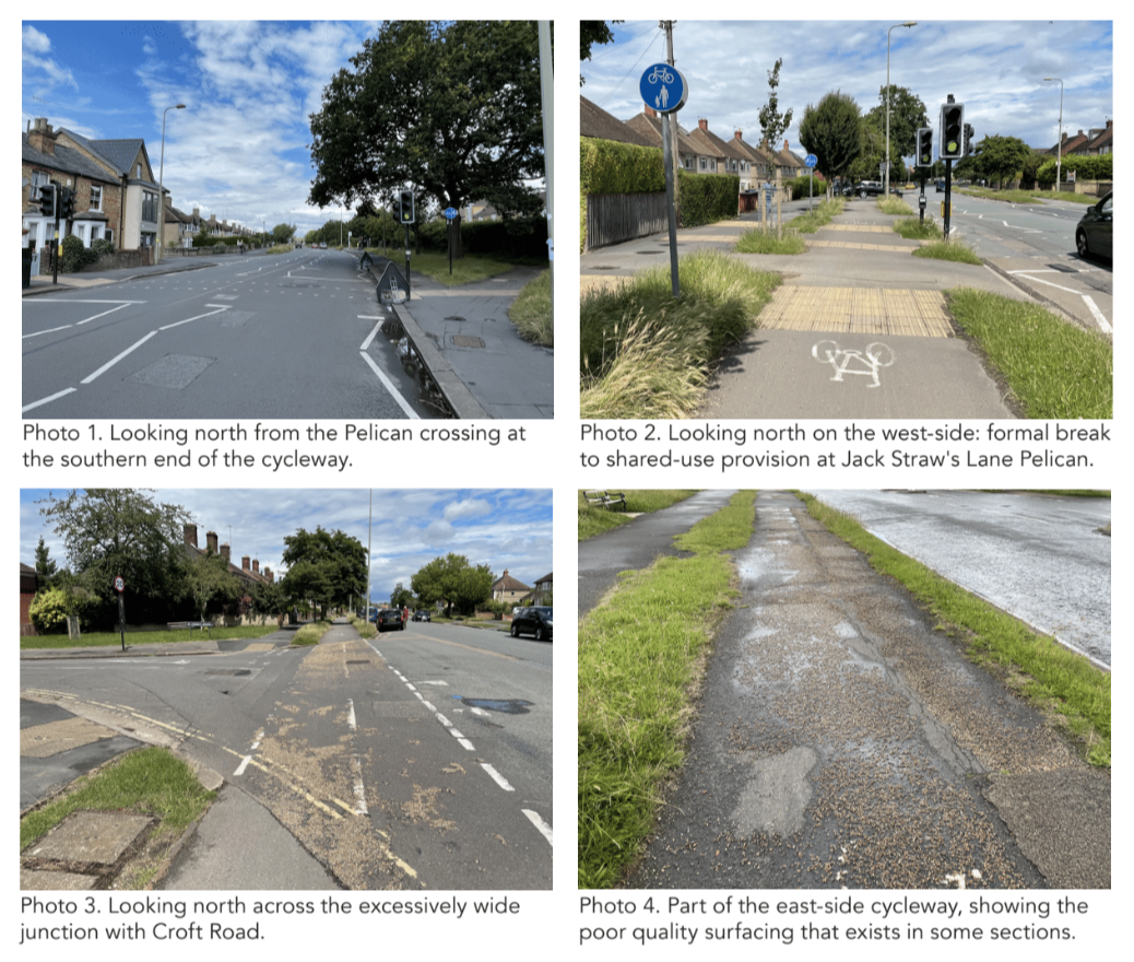
By comparison, the northern end of Marston Road, between Old Marston Road and the B4495 Cherwell Drive has a quite distinctive layout. Around 220m long, it is roughly as wide as the part of Marston Road containing the 1930s scheme (around 21m, somewhat over 70ft), but the space is used quite differently. It is a dual carriageway with each carriageway around 6m (20ft) wide and a central reservation (grass and two trees) of around 2.1m (7ft). On both sides there’s a footway around 2.4m (8ft) wide and, on the east side only, there’s also a planted verge (grass and trees) around 2.1m (7ft) wide.
In summary, this stretch is quite wide enough to accommodate exactly the same walking and cycle facilities as the 1930s scheme.
The housing typology along the full length of Marston Road from Cherwell Drive to Edgeway Road is remarkably consistent: two-story semi-detached houses, most of which now have parking on their forecourts/front gardens.
THE CHALLENGES
There are comparatively few challenges to restoring the 1930s cycleways themselves, so that they are suitable for contemporary use. They would benefit from being resurfaced and from any verge encroachment trimmed back, but otherwise need little attention.
The bus stop layouts – three on each side – generally work well, with shelters (where present) in the verge between footway and cycleway and flagsand boarding/alighting platforms in the verge adjacent to the carriageway.
The principal issues – as so often with 1930s schemes – are the layouts at junctions. Concerning side junctions, there are two on the west side (Nicholson Road and Croft Road) and four on the east side (Harberton Mead, Jack Straw’s Lane, Lynn Close and Crotch Crescent).
In addition, on the east side opposite the Old Marston Road junction, eight properties are set back from the general alignment and are accessed via a service road crescent.
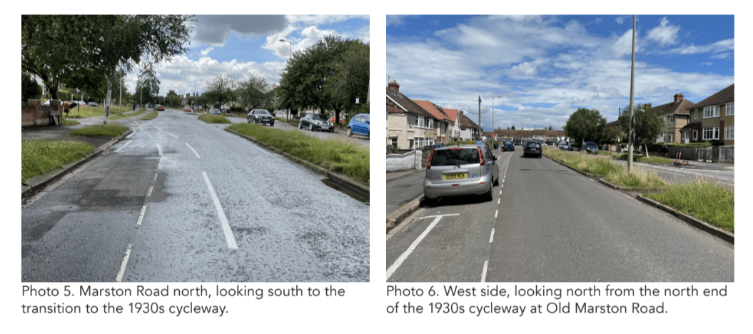
There is both a northern and a southern junction between this crescent and Marston Road proper (with the island between containing the northernmost section of parallel cycleway and footway). All these side access are unnecessarily wide and, despite some having been subject to comparatively recent treatment, none meet the standard set out within LTN 1/20 Figure 10.13.
As for the junctions at the scheme ends – Old Marston Road (north) and Edgeway Road (south) – the transitions are poor. Characteristically, the original cycleways simply started/stopped with simple ramps from/to the main carriageway. Although the southern termination point on the east side is now coincident with a signalised crossing point, this crossing is (at present) just a Pelican, not a Toucan.
THE OPPORTUNITY
The value of the 1930s cycleways on Marston Road rests in their role as potential links with other parts of the contemporary cycling network.
To the north, there are good or very good cycling facilities along the B4495 (Cherwell Drive and Marston Ferry Road). These run to, past or near numerous schools: St Nicholas Primary School, the Swan School, Cherwell School (two sites) and Oxford High School.
In 2019, new cycling facilities were introduced on Cherwell Drive between Marston Road and Oxford Road; and west of here (Marston Ferry Road) there is a 2km-long, 4m+ cycleway and adjacent footway on the south side dating from 1969 and entirely separate from the carriageway.
To the south, Edgeway Road leads to the popular Marston Cycle Path that runs for about 750m across New Marston Meadows and between parks to connect with Oxford city centre via South Parks Road. So, if the transition between the old cycleways and Edgeway Road can be improved, and good cycle facilities introduced on the ‘missing link’ at the north end of Marston Road, the 1930s scheme can be transformed from a historic oddity into a facility that helps create a joined-up cycling network of quality in north-east Oxford.
Being already aware of this potential, Oxfordshire County Council, the highway authority, has prepared proposals for improvement that cover the whole of the B4150 Marston Road, from the A420 Headington Road/St Clement’s Road in the south to the B4495 in the north. A plan from Oxford’s 2019 LCWIP, shows Marston Road is the southern part of route OXR7, with the B4495 as OXB and the Marston Cycle Path as OXR6.
The plan also shows Old Marston Road and the southern part of Oxford Road as a direct link between the north end of the 1930s scheme and the east end of the 1969 Marston Ferry Road scheme.
Improvements along this alignment should be progressed in addition to those recommended above for the northern end of Marston Road and the junctionwith Edgeway Road.
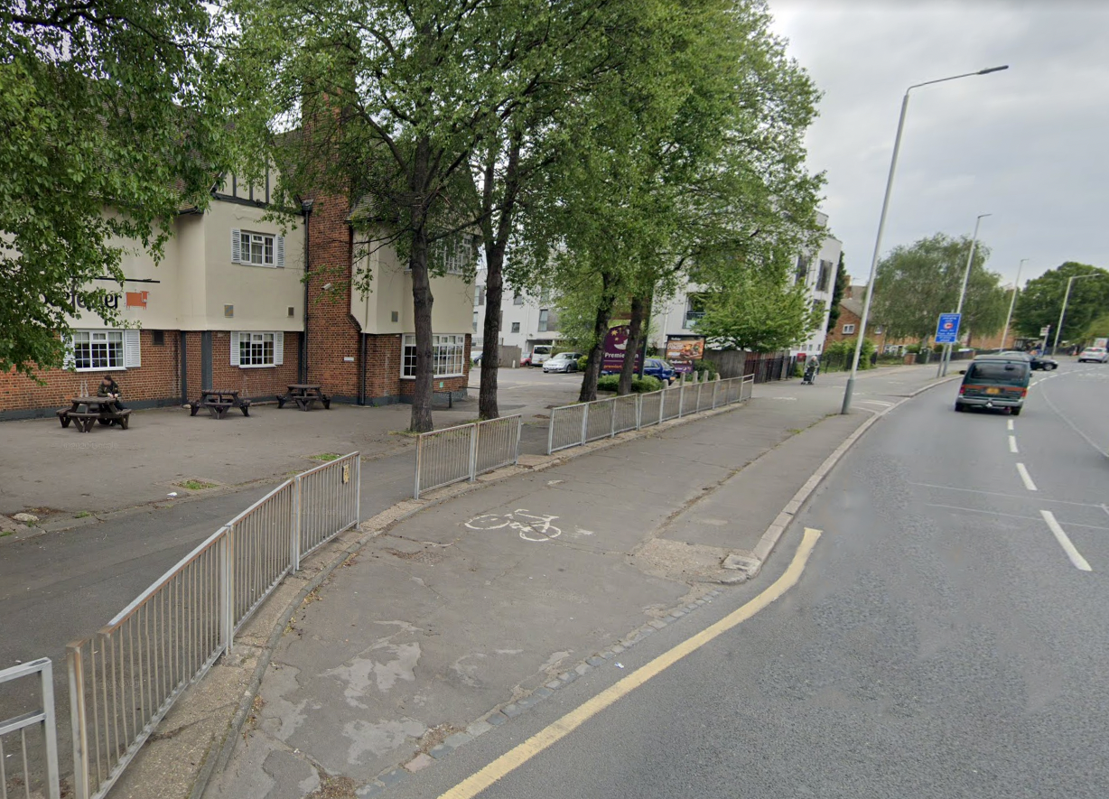
Uxbridge Road, Hayes, Hillingdon
Location: A4020 Uxbridge Road, Hayes
Original Length: At least 1.85km; probably 2.9km
Authority: London Borough of Hillingdon
While records from the Hayes and Harlington Urban District Council show that improvements to the Uxbridge Road in Hayes were under consideration from late 1935, no documentary evidence has yet been found concerning the date or the precise extents of the cycleways on both sides of the Uxbridge Road in Hayes.
In 1976, 517 local cyclists presented a petition to Greater London Council asking for a “ban on parking on the track”, and the GLC acceded to their wishes, saying in a press release that “The order will be the first of its kind for non-trunk roads in London.”
It doesn’t appear that the GLC knew about the age of the track it was defending, with the press release simply describing it as “About 1.75 miles long… purpose-built and separated from the roadway.”
The general character of the cycleways, including the adjacent footways and dual carriageway, are indicative of a 1930s design, while an aerial photo from 1941 seems to show the eastern end of the scheme.
1960 mapping and mid-1960s photos both clearly show the cycleways.
Putting the matter of age to one side, the eastern end of the Hayes cycleways is a short way west of the present-day boundary between Hillingdon and Ealing, which is at the bridge over the Paddington Arm of the Grand Union Canal (Bridge 20).
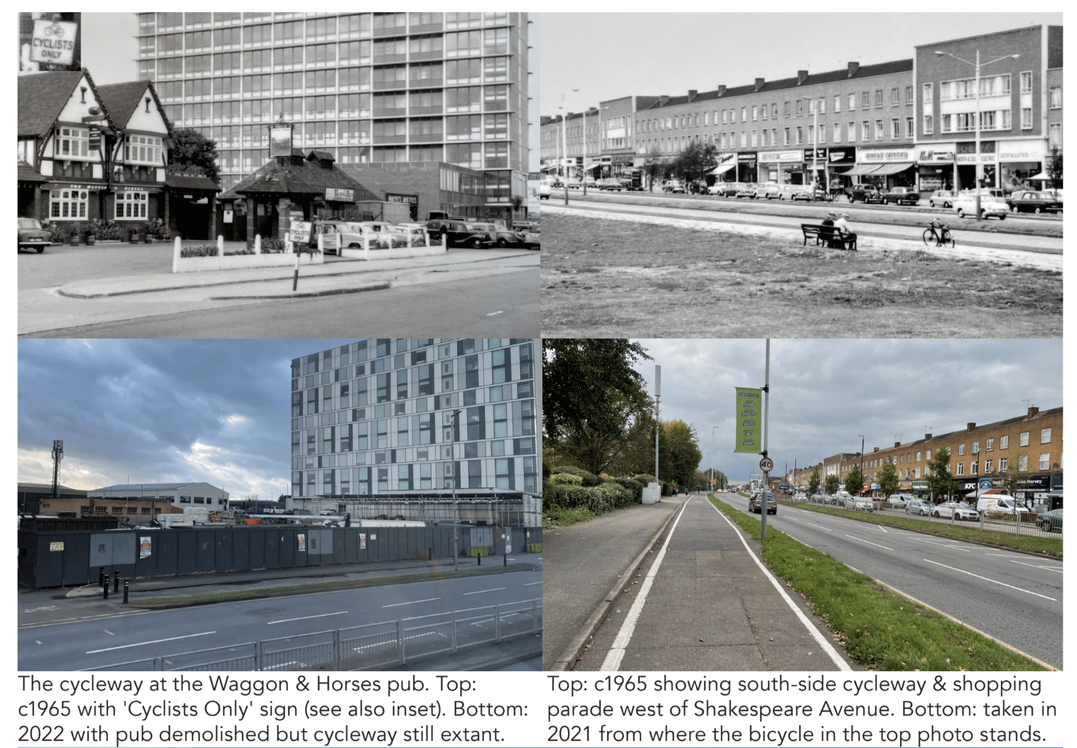
The location of the western end of the scheme is somewhat less clear, since the available historic mapping is insufficiently detailed west of of the junction of Warley Road with the Uxbridge Road.
However, the scheme will originally have extended at least as far west as Church Road (1.85km) and almost certainly as far west as Grange Road/Lansbury Drive (2.25km). West of Lansbury Drive, there is, and seems likely always to have been, a gap in provision as far as the eastern end of Park Road Green (just over 100m).
The parallel footway and cycleway arrangement then reappears and continues almost as far as the junction with Hayes End Road, definitively coming to an end at what is now the junction of Church Close and Westcombe Lodge Drive. That would make the total length of the scheme around 2.9km, and this tallies with the GLC’s 1976 statement that it is “about 1.75 miles long.”
The basic layout template differs from many others we’ve seen, there being a verge between carriageway and cycleway but then a simple kerb step transition to the footway (i.e. no verge between the two). The boundary between the verge and cycleway is sometimes flush and sometimes a kerb step down (from the verge).
Today, the verge is usually hard-surfaced, but there is grass in some sections. Historically, as today, the cycleway is absent on the north side, between Warley Road and Shakespeare Avenue, where cycling was/is incorporated within the service road for the adjacent shopping parade.
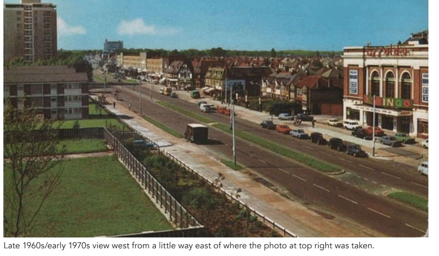
In 2016/17, the north side of the Uxbridge Road was subject to a comprehensive public realm treatment between Lansbury Drive (west) and just east of the Warren (the treatment ends at the boundary between the Lidl supermarket and bingo hall/old cinema sites). The most significant structural change affecting the original cycleways was the construction of the Hayes Bypass and Ossie Garvin Roundabout (opened 1992), which were completely new and unrelated to previous road layouts in the area.
(There were previously no roads or junctions between Quebec Road and Wimborne Avenue.)
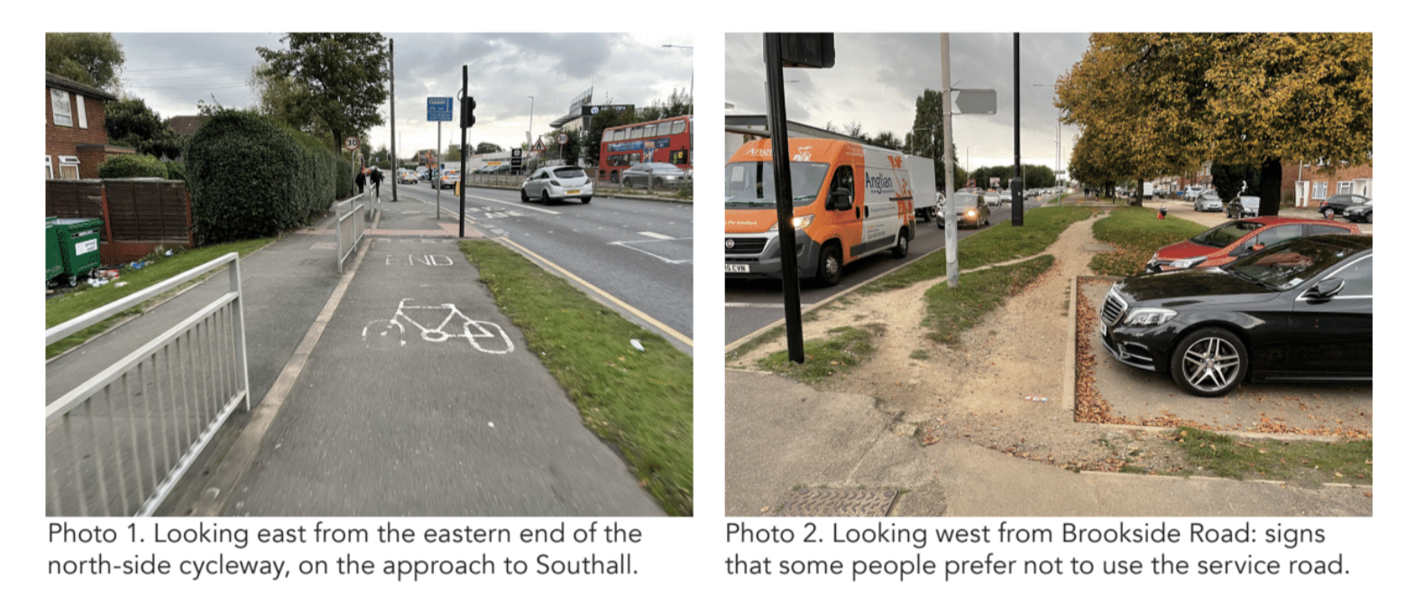
Although the Ossie Garvin Roundabout destroyed the original cycleways in the vicinity, new cycle tracks, with adjacent footways, were re-provided across all four arms of the new junction. These connect with the new cycle track that was constructed along the west side of the Hayes Bypass, and which still provides acontinuous connection – of varying quality – with the A4 Bath Road, over 4.5km to the south.
THE CHALLENGES
Being a comparatively long scheme by 1930s cycleways standards, and running through a complex urban environment as it does, all of the characteristic flaws of such schemes are present along the Uxbridge Road, often repeatedly.
- The conditions of the surface is highly variable – understandably depending on how recently any given section was subject to renewal.
- On some stretches, the original separate cycleway and footway have been merged to form a single shared-use path; although these usually have the saving grace of being adequately wide.
- The cycleways and adjacent footway have poor priority at side junctions of all kinds, whether these are uncontrolled with comparatively quiet side streets or accesses, or whether they’re signalised at busier locations .
- The cycle route, though long and serving a number of useful destination on either side, does not form part of a connected network. There are cycle facilities of some description along the Uxbridge Road all the way from Hayes to Uxbridge itself (approximately another 4km), but these fall way below the 1930s standard; and there is the track alongside the A312 Hayes Bypass. But there are no dedicated cycling facilities on the Uxbridge Road through Southall and no other north-south routes.
- Somewhat ironically, the construction of the Ossie Garvin Roundabout led to the creation of a good standard of cycling provision across all arms – whereas 1930s cycleways would simply have stopped at such a major junction, returning people on cycles to the main carriageway.
The ‘best’ example of this in the original scheme was probably at ‘The Grapes’ junction – the staggered crossroads with Coldharbour Lane (south arm) and Yeading Lane (north arm) – the old A312. This junction has since been made even larger, and signalised.
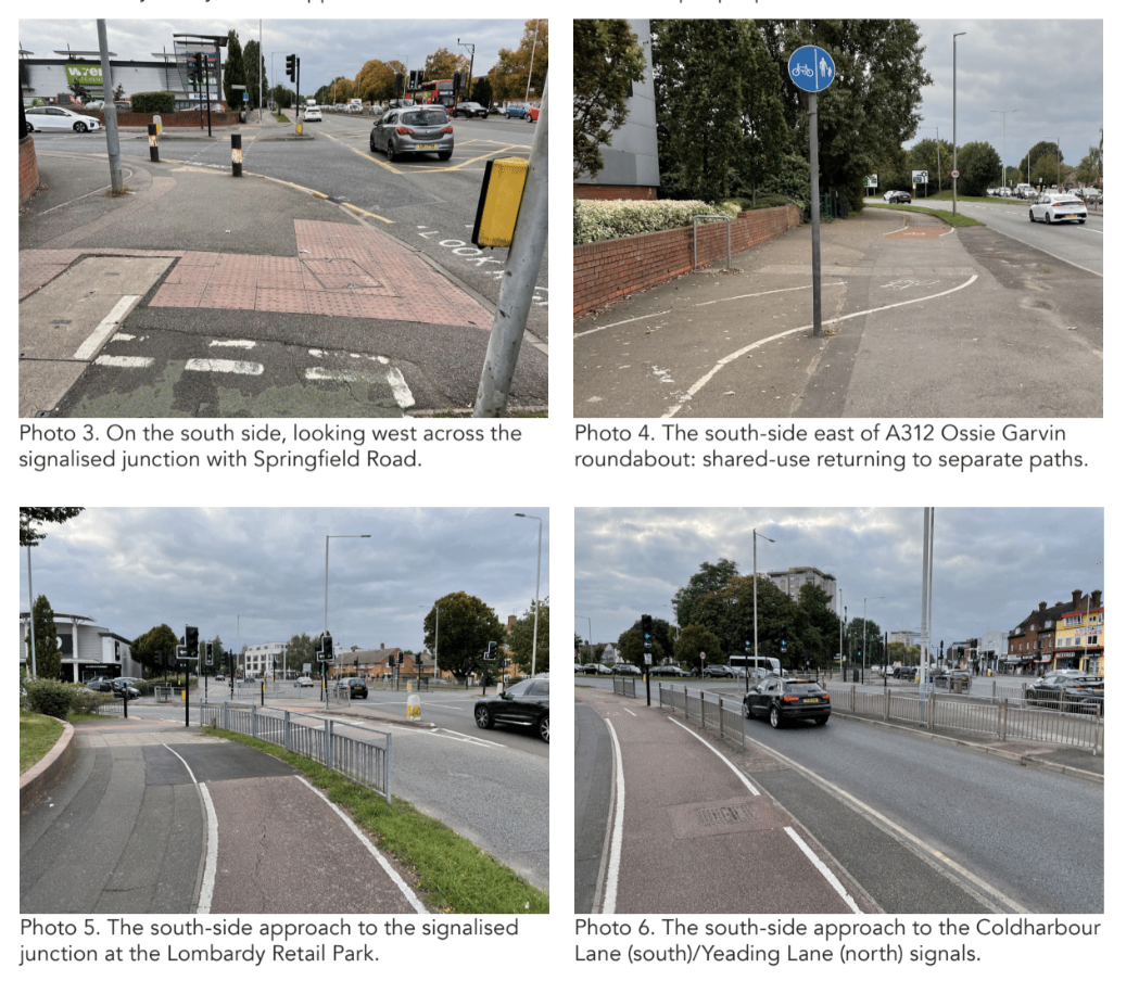
People on cycles are no longer required to use the main carriageway, the cycling facilities provided afford so low priority, and incur long waits, that some people prefer to ride with the main road traffic.
- Just east of the Grapes junction, and west of the Ossie Garvin Roundabout, a new large signalised junction was created to enable access to the Lombardy Retail Park, which opened in the early 1990s (at the same time as the Hayes Bypass). Though affecting only the south-side cycleway, it creates much the same, poor conditions for cycling as at the Grapes.
- As mentioned, on the north side, between Warley Road and Shakespeare Avenue, there is a 300m section where the distinct cycleway is absent and cycling was (and is) supposed to take place in the service road that runs in front of the shopping parade. Though relatively rare, this is feature of several 1930s schemes. The idea was that traffic flows in such service roads would be low and slow – since they are for local access only. However, the presence of the retail units in this particular location mean that the service road is often very busy; and although parking is only supposed to take place on one side, illegal parking is commonplace on the other. As things stand, this is not a welcoming environment for cycling.
- As also mentioned, there seems always to have been an absence of any provision for cycling in the 100m section between Lansbury Drive and the east end of Park Road (to the west). Although there is now a ‘segregated shared-use’ path on the south side (around 3-3.5m wide), people cycling east on the north side of Uxbridge Road are obliged to go in the main carriageway past several parking bays, most of which are perpendicular to the carriageway (Photo 12).
- Near the east end of the scheme, the cycleway also gives up, for no obviously good reason, for a stretch of around 50m on the north side, immediately west of Brookside Road. This is not contemporaneous and may possibly be alegacy of changes made when the Ossie Garvin Roundabout was constructed.
THE OPPORTUNITY
The Uxbridge Road through this part of Hayes runs through an area that is largely residential to north and south, and provides access to a large number of shops and other services. It also forms part of a historic radial route in outer west London and has the potential to be used for daily journeys to and from key destinations to west and east, like Uxbridge and Ealing metropolitan town centres, the main campus of Brunel University, Ealing Hospital, employment areas, and numerous schools, including the Guru Nanak Sikh Academy.
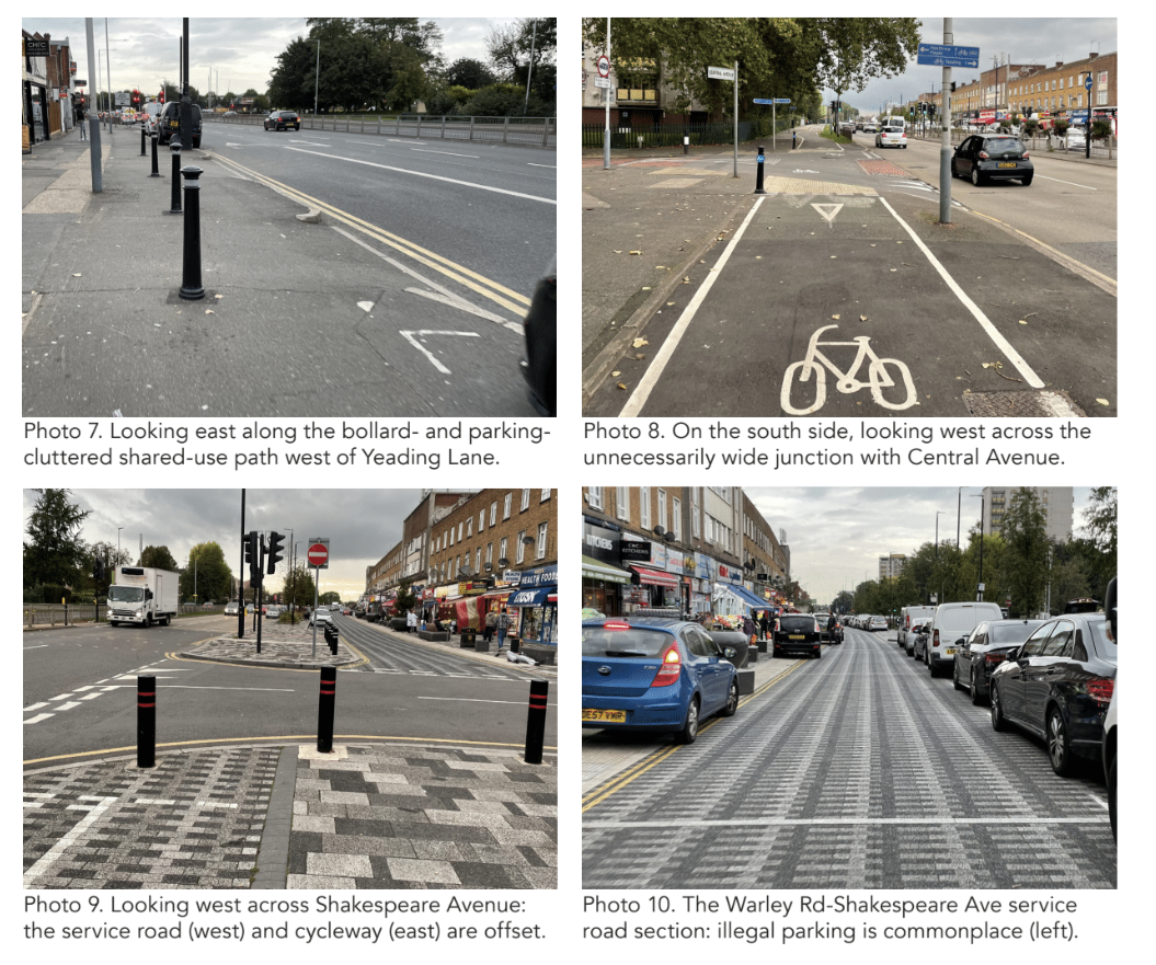
To maximise the potential of the historic cycleways to enable people to undertake short- and medium-distance trips on cycles instead of by car, a package of different types of improvement measures can be brought forward over the coming years. These should address each of the challenges listed above, and will comprise a range of interventions from the routine to major junction schemes.
- A schedule should be prepared describing the current condition of the cycleways and footways – or, where present, the shared-use paths – and what (if anything) it will take to bring each section up to an LTN 1/20 compliant standard. In places, this will need little more than basic maintenance (including de-cluttering), but in others there will need to be resurfacing (possibly reconstruction) and perhaps some space reallocation or even modest widening. The objective should be to have a minimum 2m-wide footway and 3m-wide cycleway – the latter bearing in mind that it will be necessary to enable bi-directional cycling on both sides of the road.
- The layout at all side-street junctions and other side access should also be reviewed as an early task, since repeated interruptions to journeys along dedicated cycleways is one of the main reasons why people chose instead to cycle in the main carriageway – or to travel other than by cycle. For comparatively quiet, uncontrolled junctions, the present layouts, which do not prioritise walking and cycling across, should be improved in line with Figure 10.13 of LTN 1/20.
- At the simpler signalised junctions (i.e. excluding the Grapes and the Lombardy Retail Park), direct, wide, single stage crossings should be provided, ideally with separate walking and cycling paths.
- At the Grapes and Lombardy Retail Park junctions, major improvement schemes – and associated dedicated funding programmes – should be developed. An option for the redevelopment of the Grapes junction that was prepared for Hillingdon Council in 2015 shows how a less traffic-dominated layout would not only enable better walking and cycling arrangements but also release an appreciable parcel of land, which could help fund the changes. An opportunity of this scale may not exist at the retail park access junction, although it would be worth exploring with the owners whether a re-forming of the junction in association with changes to the existing parking provision could enable the release of land for new development. As a minimum, a simple T-junction arrangement should be formed.
- Proposals to fill the ‘missing links’ should be developed – specifically those just west of Lansbury Drive and Brookside Road.
- Access and parking arrangements for the service road between Warley Road and Shakespeare Avenue should be reviewed. It is important that the safety of cycling in both directions is not threatened either by vehicle speeds or indiscriminate parking. Parking arrangements on the connecting link between Lidl and Yeading Lane also need attention.
- Where bollards are used to prevent vehicle access, those located across the cycleway should be replaced with more forgiving designs than the existing solid metal fixtures.
- The quality of all signalised crossing points should be reviewed to ensure they make good provision for people walking and on cycles.
A focus on developing and implementing a prioritised, multi-phase programme of measures covering all of the above could transform the experience of cycling and walking along this near 3km-long section of a major road in little more than five years.
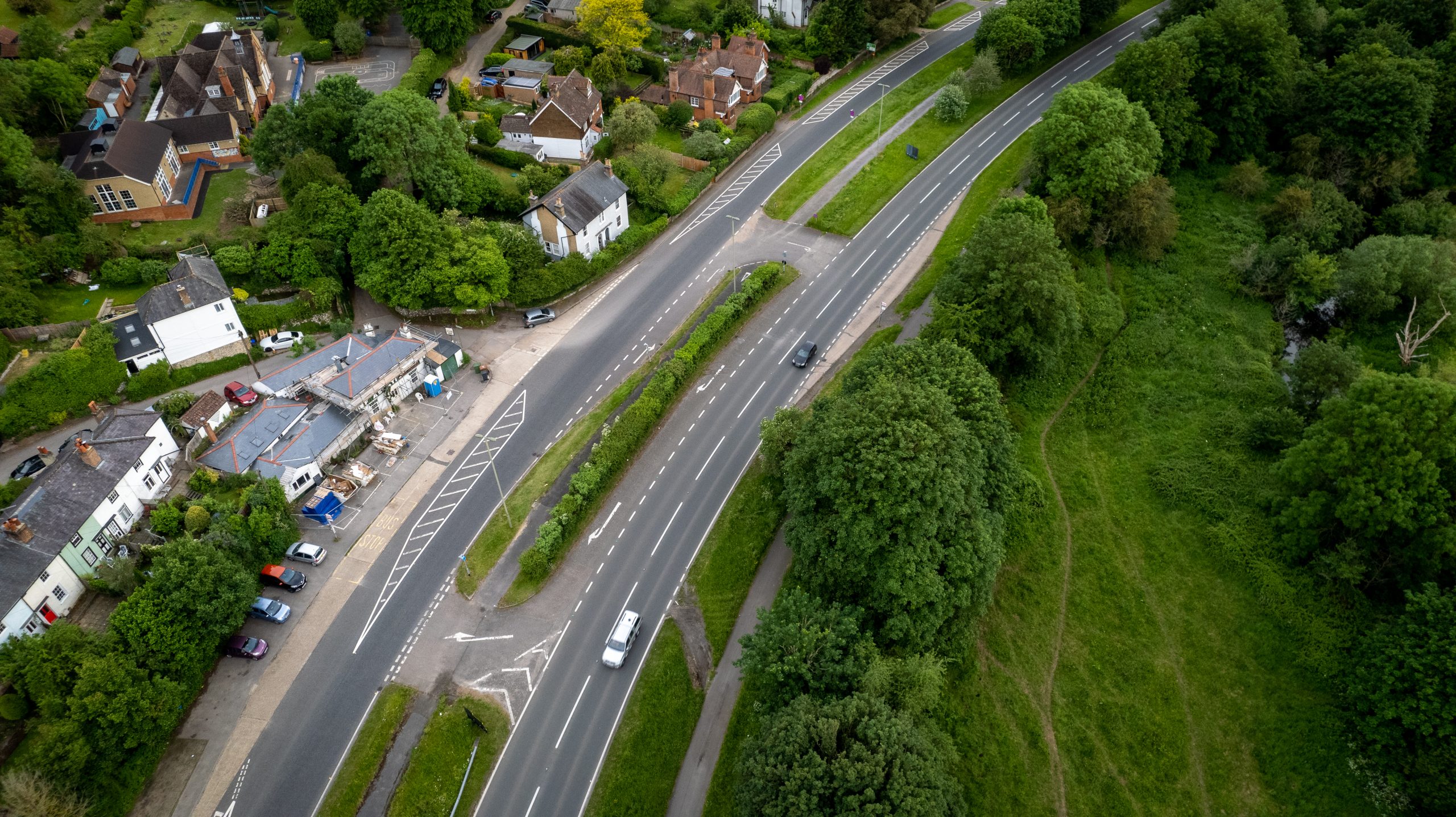
Mickleham Bypass, Leatherhead-Dorking, Surrey
Location: A24 Mickleham Bypass, between Leatherhead and Dorking, Surrey
Original Length: At least 3.9km; probably 5.2km
Authority: Surrey County Council
According to the Surrey Mirror of New Year’s Day 1937, “The work constructing the Mickleham by-pass road was begun November 1st, 1935… Each of the two carriageways will be 20ft. wide (increasing to 24ft. on bends) each cycle track will be 9ft. wide and the footpath will be 6ft. wide.”
The bypass opened in two stages, in November 1937 and June 1938. The design was by the county engineer of Surrey, Mr. W. P. Robinson. In his paper ‘The Design and Construction of the Mickleham By-Pass’, delivered to fellow engineers in 1937, Robinson stated that the bypass was 2.43 miles in length and its estimated cost, including the new bridge over the River Mole at Burford, together with land and property, was £125,500.
Photographs of the Mickleham Bypass – and its cycle tracks – were much used in the road-building literature of the 1930s, 1940s, and 1950s.
The north end of the scheme is at the Givons Grove Roundabout (A24/A246/Dorking Road).
At 2.43 miles (3.9km) long, the southern end would be at the roundabout with the southern end of the Old London Road just north of Burford Bridge.
However, parallel cycleways and footways are also present south of the roundabout, on both sides of the A24, up until the point where the 1961 map shows the road narrowing significantly to cross the railway on a bridge.
It is not yet known for sure whether this southernmost section (0.8 miles/1.3km) was also built in the 1930s or some time later. The scheme has a unique feature, thankfully one not found elsewhere (to date): a 1.6km stretch of one of the cycleways is within the central reservation!
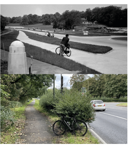
While, for the rest of the scheme, a footway and cycleway were constructed on both sides of the road, for the stretch immediately south of the Givons Grove Roundabout and as far as the junction with Old London Road immediately north of Mickleham village, what would normally have been expected to be the east side cycleway was constructed in the wide planted verge between the two parts of the dual carriageway.
While this was recorded in a matter-of-fact way in the Surrey Mirror report – “Along this section the cycle tracks will be between the two carriageways” – no evidence has been found as to why Robinson thought that requiring cyclists to cross a carriageway to reach the protection might be a good or necessary idea; and no access provision other than simple lanes was ever provided.
The central track still exists today, but is in poor condition, largely overgrown, and only used by the odd person with an over-developed sense of adventure.
Partly because there is no east-side provision in the north of the scheme, the east-side cycleway that did and does still exist between the twojunctions of the A24 with Old London Road is very little used today, and may always have been so. It is understandably in poor condition.
On the west side, the once separate footway and cycleway between the Givons Grove and BurfordBridge roundabouts have – over time – become a single shared-use path of varying width. It is generally well-surfaced and also well used: almost exclusively by people cycling for leisure.
This leisure activity is drawn by the fact that the area is part of the Surrey Hills Area of Outstanding Natural Beauty (designated in 1958) and perhaps specifically by the role of the A24 as a principal access to Box Hill, which is a very popular National Trust destination.
The Zig Zag Road connecting Old London Road with the NT cafe and Box Hill viewpoint has been especially popular with cyclists since the 1880s and was made yet more famous by its use for the road cycling events at the 2012 Olympic Games.
National Cycle Route NCN22 runs from Dorking along the A24, leaving it for the Old London Road at Burford Bridge and passing the bottom of Zig Zag Road.
THE CHALLENGES
The 1930s cycleways along the Mickleham Bypass stopped short of the towns at either end – Leatherhead to the north and Dorking to the south. This is perhaps the main challenge to be addressed in maximising the contemporary value of the investment in walking and cycling made in the 1930s.
Meeting it will require addressing the following specific issues, which are listed from north to south.
- The approximately 500m long stretch of the B2450 Dorking Road between the town centre and the junction with Thorncroft Drive has no facilities to assist cycling and is uphill on approach to the town centre.
- The wholly separate shared-use path on the west side of the B2450 between Thorncroft Drive and the Givons Grove Roundabout is not as wide as it could (and should) be.
- The crossing point of the west arm of the Givons Grove Roundabout, which connects the B2450 shared-use path (north) and west-side 1930s cycleway on the A24 (south) provides no priority to walking and cycling and involves separately crossing entry and exit carriageways that are wide and carry fast-moving traffic.
- Between the Givons Grove Roundabout and the Burford Bridge roundabout, the once separate 1930s footway and cycleway on the west side are now a single shared-use path that should (and could) usefully be appreciably wider.
- Walking and cycling priority over the few, very minor side accesses on that stretch is poor.
- At the northern junction of the A24 with Old London Road, facilities for people on foot or cycle to cross the A24 from the west-side shared-use path (actually north-side in this location) are essentially non-existent; yet this is the principal access to Mickleham village itself.
- Comparatively recent modifications to the Burford Bridge ’roundabout’ – specifically, widening so that northbound A24 traffic can travel directly through the junction without having to give way – mean that there is a pinch point on the west-side walking/cycling path between the junction and the junction with Westhumble Street, about 200m to the south.
- The subway that connects the foot/cycle paths on the west and east sides of the A24 just north of Westhumble Street is narrow and requires people on cycles to dismount.
- The junction of the A24 with Westhumble Street is now laid out in a way that prioritises the fast movement of motorised traffic over walking and cycling across.
- Parts of the cycleways on both sides of the A24 between Burford Bridge and the Denbies Estate (Bradley Lane/Pixham Lane) roundabout are in need of maintenance attention, and informal parking on the east side is a problem.
- Walking/cycling priority across all arms of that roundabout is poor.
- Between the Denbies Estate Roundabout and the large, signalised junction of the A24 with the A2003 Ashcombe Road the 1930s scheme petered out. Walking/cycling provision is either an inadequately narrow shared-use path or in-carriageway.
- The A24/A2003 junction has no walking/cycling crossing facilities over either of the A24arms, despite Dorking and Dorking Deepdenestations being nearby on the east side.
- Onward walking cycling links from the A24/A2003 junction to Dorking town centre (via London Road) are poor.
THE OPPORTUNITY
The most obvious opportunity concerning the Mickleham Bypass cycleways is to build upon them so that they are transformed from a rather wonderful historic oddity into the core of a high-quality modern cycling route between Dorking and Leatherhead.
Despite a seemingly long list of challenges, there are no insuperable obstacles to improving and extending the 1930s facilities in ways that also provide access to the following destinations along the way: the No.1 Pixham End business park; the Denbies Wine Estate; West Humble village; Box Hill; and Mickleham village.
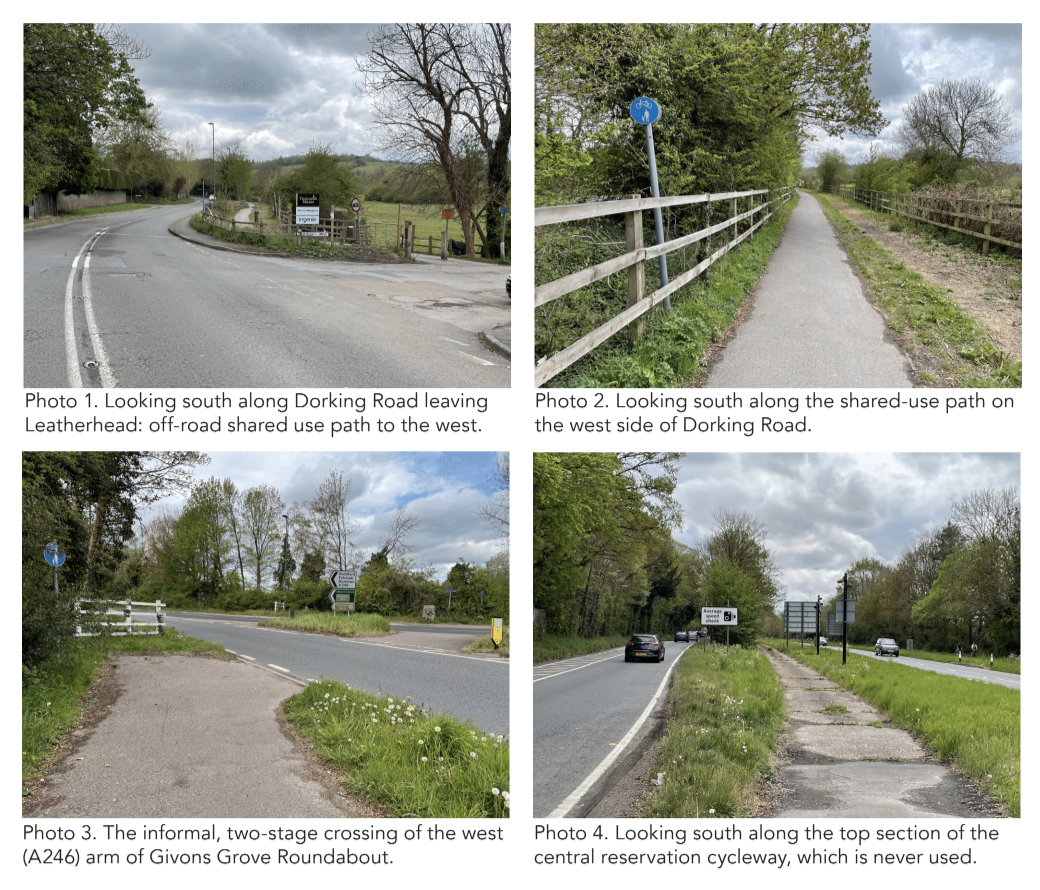
The complete link would be around 5 miles/8km long, and more or less flat, making it less than 30 minutes to cycle between the towns, less at a modest pace. People from both towns, including whole families, would be enabled to visit the different attractions along the way without having to resort to the car, as most who have one will feel they need to at present.
To make this happen would be to honour the status of the AONB, as well as the foresight and endeavour of those who helped build the original scheme.
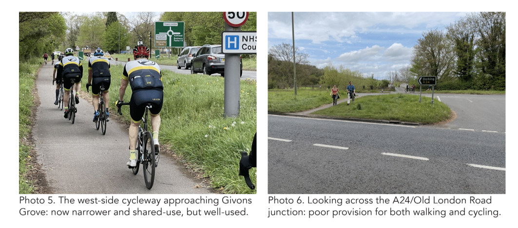
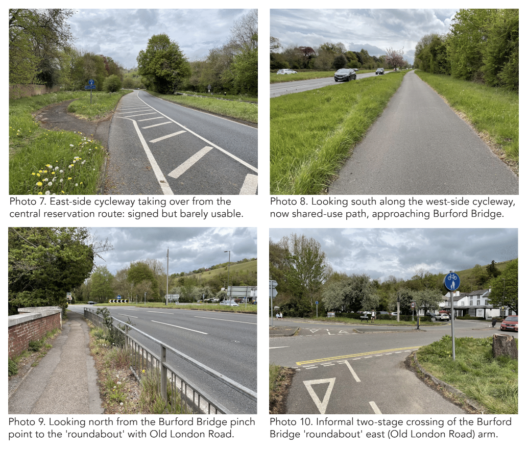
A comprehensive programme of different types of measures can be developed that is capable of implementation in stages and flexible in response to the availability of funding for the different elements at different times. Again listed from north to south, this package should embrace the following elements.
- Traffic, speed and parking management measures on the north section of the A2450 Dorking Road in Leatherhead to enable safe and comfortable cycling in the carriageway.
- Widening of the shared-use path on the west side of Dorking Road; or the creation of a separate footway and cycleway in the corridor.
- Signalisation of the crossing of the west (A246) arm of the Givons Grove Roundabout, including widening of the link to the walking/cycling path to the west of the B2450.
- Widening of the west-side shared-use path alongside the A24, and modifying the minor side access junctions to increase priority across.
- Improved crossing facilities over the A24 at the north junction of Old London Road, including consideration of a signalised facility.
- Modifiying the Burford Bridge ’roundabout’ to create a conventional roundabout at which all approaches are required to give way. This will enable realignment of the northbound A24 carriageway to create space to widen the walking/cycling path on the west side of the road, as far south as Westhumble Street. The current arrangement, whereby northbound traffic on the A24 is not required to give way to other traffic streams, dates back to the 1990s at least, but it would not appear to be a capacity critical arrangement.
Crashmap suggests that, in the five years 2017 to 2021, there were ten collisions on the northbound carriageway at or between its junctions at Burford Bridge and Westhumble Street. These resulted in 11 injuries, four of which were recorded as serious. One contributory factor in these collisions may have been vehicle speeds.
- Modifying the A24 junction with Westhumble Street to enable safer, more direct and more convenient crossing by people on foot and on cycles. The current layout enables vehicles to turn left in at a higher speed than is desirable, while the two lane exit seems an attempt to help drivers with the challenge of either turning into gaps in the fast moving traffic stream, or crossing that stream to access the right turn lane for Old London Road at the Burford Bridge ’roundabout’.
- General improvements to the historic cycleways and footways on both sides between Burford Bridge and the south end of the scheme.
- Improved crossing facilities over all arms at the Denbies Estate roundabout.
- New/improved cycling and walking facilities onboth sides between the south end of the 1930s scheme and the Ashcombe Road junction. New crossing facilities over the A24 on the north arm of the Ashcombe Road junction.
- Improved cycling and walking facilities on the west side of the A24 and along London Road, linking the Ashcombe Road junction with Dorking town centre.

