
Middle-of-the-road cycle track on Mickleham Bypass.
The bypass of the village of Mickleham is near Leatherhead, 25 miles south of London. Mickleham is close to Box Hill and its Zig zag road, popular with cyclists and used for the road cycling events in the 2012 Olympics.
“The work constructing the Mickleham by-pass road was begun November 1st, 1935,” said a newspaper in 1937.

This middle-of-the-road section of the track is overgrown and likely little used by cyclists.
“Each of the two carriageways will be 20ft. wide (increasing to 24ft. on bends) each cycle track will be 9ft. wide and the footpath will be 6ft. wide,” continued the report.
The bypass opened in two stages, in November 1937 and June 1938.
The design was by the county engineer of Surrey, Mr. W. P. Robinson. In his paper The Design and Construction of the Mickleham By-Pass delivered to fellow engineers in 1937, Robinson stated that the bypass was 2.43 miles in length and its estimated cost, including the new bridge over the River Mole at Burford, together with land and property, was £125,500.

Period OS map showing the middle-of-the-road cycle track.
The cycle tracks and footways show up vividly on Google Earth’s 1945 layer; they extend for half a mile more than the length stated in 1937.

A view of the A24 Mickleham Bypass from the top of Box Hill, Surrey, 12th June 1939.
Photographs of the Mickleham Bypass – and its cycle tracks – were much used in the road-building literature of the 1930s, 1940s, and 1950s. The pictures tend to show that the cycle tracks were well used.
The cycle track sandwiched between the two carriageways at Mickleham village wasn’t shown in these period photographs.
“A new road — the ‘up’ highway — cycle tracks and a footpath will be constructed inside the present boundary hedges and fences of the Norbury Park Estate,” reported a newspaper in 1937.
“Along this section the cycle tracks will be between the two carriageways,” it stated matter-of-factly, as if such an arrangement — where cyclists had to cross carriageways to reach the protection — was perfectly normal.
Why Robinson made cyclists into the meat filling of an automotive ham sandwich has not been revealed by research. This middle-of-the-road cycle track — with period concrete surface — is today much overgrown and is probably never used by cyclists. (And not just because local residents park cars on it.)
A period photograph gives a good view of the southern end of the bypass. It’s by an unknown photographer, shooting on a Leica camera, and who very probably owned the car beside the “Cyclists Only” sign (the same vehicle can be seen in other photographs in the collection). Probably dating from the 1940s, the photograph shows a man in smart trousers and a jacket leaning on a roadster bicycle. The cycle track and the road — both capped with concrete — gleam white in the sunlight. Five cars are in motion and there are nine cyclists in the photo, all on the cycle track. There are three motorcyclists on the road.
The footway seen in the photograph is mostly gone (now buried under grass, and trees, and encroached by fencing) but, as Google Street View shows, the roundabout is still there and the cycle track is still there, too. There’s now a speed camera sign where before there was a “Cyclists Only” sign.


Entrance for the middle-of-the-road cycle track on the Mickleham Bypass.

Entrance to the cycle track at Burford Hotel roundabout, Mickleham Bypass. The sign next to the car reads “Cyclists Only.”

Maps show the middle-of-the-road cycle track on the bypass.
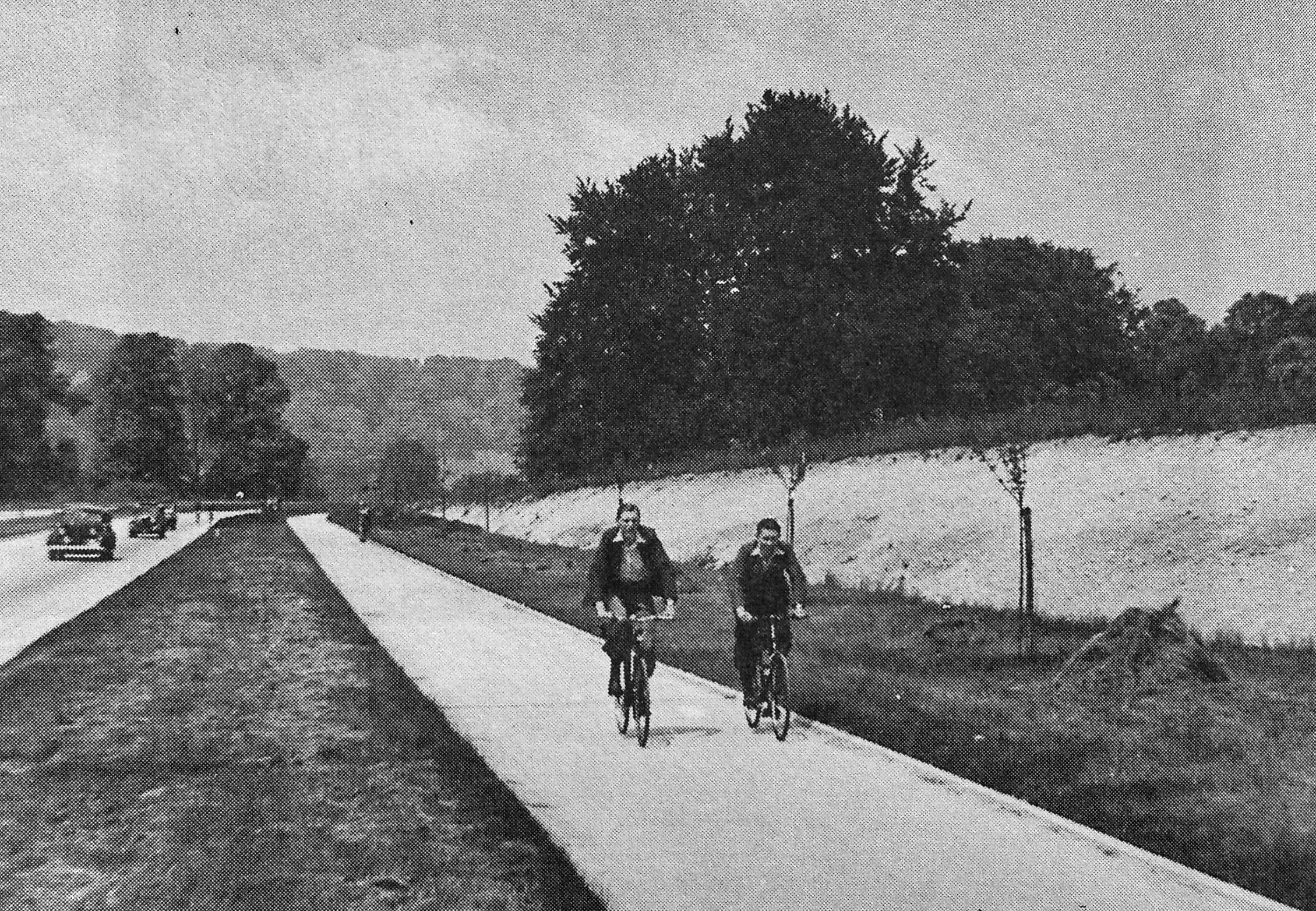
Two period cyclists on the Mickleham Bypass.


